BOTTOM LINE
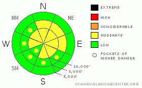
Danger by aspect and elevation on slopes approaching 35° or steeper.
(click HERE for tomorrow's danger rating)
|

Danger Rose Tutorial
|
For the first time since December 14th, we have lowered the overall danger rating to MODERATE. This means that “dangerous avalanche conditions on some terrain features. Evaluate the snow and terrain carefully and use good travel habits.” You could trigger avalanches today on any steep slope with recent wind drifts and you could also still trigger some very isolated areas of deep, dangerous avalanches, most likely from shallow, steep rocky areas with a fresh load of wind drifted snow. |
|
|
CURRENT CONDITIONS |

|
What a difference a day makes, as they say. A major snow travesty occurred yesterday. At least on the north through west facing slopes, a stout layer of rime ruined all our nice powder we enjoyed so much on Saturday. The warm front and stratus clouds smashed into the upper half of the mountains with super-cooled water that froze on contact whatever it touched, creating some very loud powder. You could hear people coming from a half mile away and little pieces of snow skittered down the slick zipper crust. The good news is that the rime was not bad everywhere. It tends to coat the upwind sides of ridges and the downwind sides escaped with a much thinner coat. It’s kind of hit-or-miss. If you’re from Washington, you will feel right at home, but for the average, spoiled Utah’n, it elicits the same response as spraying a cat with a garden hose. This morning, very light snow showers are falling. Ridge top winds blew hard again last night from the northwest, blowing 30-40 with higher gusts. Ridge top temperatures have dropped to around 20 degrees. |
|
|
RECENT ACTIVITY |

|
Once again, we did not hear about anybody triggering avalanches yesterday, with the exception of some small, cornice-triggered wind slabs along the upper elevation ridges. The Uinta Mountains, however, remain active with another couple, large, natural avalanches reported yesterday morning, breaking to the ground, probably from the strong winds the night before.
|
|
|
THREAT #1 |

|
| WHERE |
PROBABILITY |
SIZE |
TREND |

|
|
|
|
| |
|
|
Over the next
24 hours.
|
|
|
Although the strong winds blew again last night from the northwest, there was not a lot of snow to blow around because it was the second day of strong winds. Still, some people were able to trigger shallow wind slabs along the upper elevation ridges. You can expect to find some hard wind slabs, mostly on east through south facing slopes and cross loaded into other slopes as well. As always, you should avoid steep slopes with recent deposits of wind drifted snow. |
|
|
THREAT #2 |

|
| WHERE |
PROBABILITY |
SIZE |
TREND |

|
|
|
|
| |
|
|
Over the next
24 hours.
|
|
|
In my snowpits from the past couple days, I have been encouraged by what I’m finding, as are all of the other observers in the Wasatch Range. The faceted snow responsible for the flurry of activity these past three weeks is getting growing quite rounded corners under my microscope and gaining strength. The columns still propagate fractures but you have to put a good wup on them and they propagate with what the Canadians call a “resistant, planar fracture.” In plain English, this means that you can still trigger a deep, large, probably un-survivable avalanche, but it is becoming very difficult to trigger. You would likely need to initiate it from a shallow, steep, rocky area. Bill Nalli sent an excellent summary of the avalanche activity in recent weeks in the UFO Bowls area on the east side of Timpanogos |
|
|
MOUNTAIN WEATHER |

|
It will feel like Groundhog Day—a repeat of yesterday but a little colder, with stratus clouds, strong northwest winds, light snow showers and ridge top temperatures in the mid 20’s. A high pressure ridge will slowly build in over the next several days with progressively warmer temperatures at upper elevation rising into the 40’s along the ridge tops by the weekend. We don’t see any significant snow for at least 10 days.
|
|
|
GENERAL ANNOUNCEMENTS |
The Utah Avalanche Center is hosting a Level 2 avalanche class in February which is now open for registration by going to the Black Diamond retail store. More information is HERE.
Beacon training parks are up and running! On the Park City side, there is one at the top of Canyon’s gondola, in Little Cottonwood one is near the Snowbird parking structure on the bypass road, and in Big Cottonwood a training park is at the west end of Solitude's lower parking lot.
If you want to get this avalanche advisory e-mailed to you daily click HERE.
For a text only version, the link is on the left side bar, near the top.
UDOT highway avalanche control work info can be found by calling (801) 975-4838. Our statewide toll free line is 1-888-999-4019 (early morning, option 8).
The UAC depends on contributions from users like you to support our work. To find out more about how you can support our efforts to continue providing the avalanche forecasting and education that you expect please visit our Friends page.
Your snow and avalanche observations help everyone in the backcountry community. Please let us know what you're seeing by leaving a message at (801) 524-5304 or 1-800-662-4140, or email us at uac@utahavalanchecenter.org. (Fax 801-524-6301).
The information in this advisory is from the U.S. Forest Service, which is solely responsible for its content. This advisory describes general avalanche conditions and local variations always occur. This advisory does not apply to ski areas or highways where avalanche control is normally conducted.
Drew Hardesty will update this advisory by 7:30 tomorrow morning. |
|
|
This information does not apply to developed ski areas or highways where avalanche control is normally done. This advisory is from the U.S.D.A. Forest Service, which is solely responsible for its content. This advisory describes general avalanche conditions and local variations always occur. |
|
This advisory provided by the USDA Forest Service, in partnership with:
The Friends of the Utah Avalanche Center, Utah Division of State Parks and Recreation, Utah Division of Emergency Management, Salt Lake County, Salt Lake Unified Fire Authority and the friends of the La Sal Avalanche Center. See our Sponsors Page for a complete list. |


