BOTTOM LINE
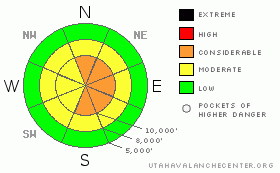
Danger by aspect and elevation on slopes approaching 35° or steeper.
(click HERE for tomorrow's danger rating)
|
Danger Rose Tutorial
|
An overall MODERATE danger will rise to CONSIDERABLE by afternoon with the arrival of denser, windblown snow on top of the light cold snow on most aspects and especially at higher elevations. Also, there are lingering pockets of CONSIDERABLE danger of deep slabs on slopes that have not yet slid, above 8,500’ on northwest, north, northeast and east facing slopes approaching 35 degrees or steeper. These avalanches are difficult to trigger but if you do they will be very large and unsurvivable. |
|
|
CURRENT CONDITIONS |

|
After the best powder weekend of the season, today conditions are changing rapidly with the arrival of a warm front, which will make our upper elevation snow slabby and tricky. Temperatures have warmed to 10 above zero as opposed to 10 below from yesterday morning at this time. Ridge top winds have picked up and are blowing 25-35 along the highest peaks, from the southwest and winds will turn northwest later today. It’s what they call “overrunning” warm air, meaning incoming warm air floats over the top of the stagnant, very cold air in the valleys. So there is an especially strong temperature inversion this morning—cold down low and warm up high. |
|
|
RECENT ACTIVITY |

|
People noticed a fresh, large avalanche in Dry Fork, in the backcountry just south of Alta’s Point Supreme. It was probably snowmobile-triggered as there were many snowmobile tracks nearby. It was 3-4 feet deep, 200 feet wide, East facing, 10,700 feet. PHOTOS. No avalanches were reported from the Ogden area except for some smaller slides (see PHOTOS from Brett Kobernik from Timp.) |
|
|
THREAT #1 |

|
| WHERE |
PROBABILITY |
SIZE |
TREND |

|
|
|
|
| |
|
|
Over the next
24 hours.
|
|
|
Today, warmer air and high winds will deposit denser snow on top of the foot of light foof on the surface. The great powder from the weekend has recrystallized somewhat under the clear skies and very cold temperatures, plus there is surface hoar especially at lower elevations PHOTOS. With a slab on top, you will likely find sensitive, soft slabs and wind slabs by mid day or later in the day as new snow accumulates and wind increases. It will be especially tricky because cold air will linger in the mountain valley bottoms and you may start out in light, cold powder down low and ascend into warmer, windier weather with dense, new snow and windblown snow on top, making slabby conditions. Be sure to jump on test slopes and constantly dig down with your hand to test the surface snow. Plus, as always, avoid any steep slope with recent wind deposits, which will look smooth and rounded. |
|
|
THREAT #2 |

|
| WHERE |
PROBABILITY |
SIZE |
TREND |

|
|
|
|
| |
|
|
Over the next
24 hours.
|
|
|
We still have to worry about our old enemy, the lingering, deep slabs, on the slopes which have not yet slid on northwest, north, northeast and east facing slopes above about 8,500’ approaching 35 degrees and steeper. It is quite pockety right now because most slopes have already slid, plus, the weak layer is now buried about 4 feet deep, under a dense, hard slab that bridges your weight, so it’s difficult to trigger but if you do trigger one, it will be very large and unsurvivable. Most salty, old dogs like me choose to avoid this kind of crap shoot and stick to safer areas such as south facing slopes and slopes that I know have already slid. |
|
|
MOUNTAIN WEATHER |

|
Ridge top winds and temperatures will continue to increase and winds will turn northwesterly later today with the arrival of a warm front. By afternoon, ridge top temperatures will rise into the lower 20’s and ridge top winds will blow 25-35 from the southwest, turning northwest. Temperatures may remain cold in the bottoms of mountain valleys and you will ascend into warmer air. I’m expecting 8 inches of new snow by Tuesday morning, possibly more in some favored areas. We should get a little break on Tuesday morning with another similar shot of snow on Tuesday afternoon through Wednesday morning. The extended forecast calls for no other significant snow for the next week or so. |
|
|
GENERAL ANNOUNCEMENTS |
If you want to get this avalanche advisory e-mailed to you daily click HERE.
For a text only version, the link is on the left side bar, near the top.
UDOT highway avalanche control work info can be found by calling (801) 975-4838. Our statewide toll free line is 1-888-999-4019 (early morning, option 8).
The UAC depends on contributions from users like you to support our work. To find out more about how you can support our efforts to continue providing the avalanche forecasting and education that you expect please visit our Friends page.
Your snow and avalanche observations help everyone in the backcountry community. Please let us know what you're seeing by leaving a message at (801) 524-5304 or 1-800-662-4140, or email us at uac@utahavalanchecenter.org. (Fax 801-524-6301).
The information in this advisory is from the U.S. Forest Service, which is solely responsible for its content. This advisory describes general avalanche conditions and local variations always occur.
Drew Hardesty will update this advisory by 7:30 tomorrow morning. |
|
|
This information does not apply to developed ski areas or highways where avalanche control is normally done. This advisory is from the U.S.D.A. Forest Service, which is solely responsible for its content. This advisory describes general avalanche conditions and local variations always occur. |
|
This advisory provided by the USDA Forest Service, in partnership with:
The Friends of the Utah Avalanche Center, Utah Division of State Parks and Recreation, Utah Division of Emergency Management, Salt Lake County, Salt Lake Unified Fire Authority and the friends of the La Sal Avalanche Center. See our Sponsors Page for a complete list. |
