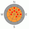
BOTTOM LINE
Danger by aspect and elevation on slopes approaching 35° or steeper.
(click HERE for tomorrow's danger rating)
|

Danger Rose Tutorial
|
The avalanche danger is Considerable with areas of High on any slope above 8,500 feet that faces northwest, north, northeast and east steeper than about 30 degrees. This means that dangerous to very dangerous conditions exist and you should avoid backcountry travel in these areas. There is also a Considerable danger of triggering fresh wind slabs deposited by strong winds today. As always, avoid any steep slope with recent wind deposits. Finally, watch for roof avalanches and wet sluffs at lower elevations. |
|
|
CURRENT CONDITIONS |

|
Temperatures continue to warm and we're expecting increasing southwest winds today and be very blustery by the end of the day. The snow surface is still quite nice and creamy on most slopes but it's starting to get a bit sun crusted on the south facing slopes with rollerballs at lower elevations. |
|
|
RECENT ACTIVITY |

|
We squeaked through another day yesterday without an avalanche involvement. In the Salt Lake area, one close call occurred along the Park City – Mill Creek on one of the ridgelines east of Little Water Peak. An experienced, snow safety professional on his day off was skinning back up on his second lap and collapsed the slope from the ridge top and a nearby, steep slope avalanched about 1000 feet wide and 4 feet deep. It did not take out his skin track. Some other collapse and cracks were noticed in Mill D South and there was some remote triggered avalanches in the backcountry north of Snowbasin yesterday. Finally, there was one natural in the Uintas in the 1000 Peaks area, probably yesterday morning. The main reason there was no avalanche incidents this weekend was that people continued to behave themselves by staying off the steep north through east facing slopes. |
|
|
THREAT #1 |

|
| WHERE |
PROBABILITY |
SIZE |
TREND |
|
|
|
|
| |
|
|
Over the next
24
hours.
|
|
|
We are entering that particularly dangerous time when the snowpack slowly stabilizes, our danger ratings continue to creep down and people's boldness continues to creep up. We are entering the dreaded, most dangerous, of all danger ratings—Considerable--where most avalanche accidents occur. The word High gets people's attention but Considerable is just a horrible word that we are, unfortunately, stuck with from an international committee. I prefer the word “serious” which gets the message across better. I'm calling the danger today Considerable with “pockets” of High, which in this case, means “areas” of High, where the entire slopes can break out 1000 feet wide and 4 feet deep. Most of these will be unsurvivable. Thankfully, many of the usual suspects have already avalanched but there still are many slopes hanging in the balance just waiting for a trigger. You can easily trigger these from the bottom or adjacent slopes or ridges. I'm still staying off any slope steeper than 30 degrees that faces northwest, north, northeast and east. If you want to go steep, go to a resort or go to one of the mid to lower elevation south facing slopes. The problem, of course, is our old enemy, the facet-rain crust combination buried about 4 feet deep, which is taking its sweet time to heal up. This is an especially tricky situation as evidenced by three inbounds fatalities this season in the U.S., each at the top resorts in the country for their state-of-the-art avalanche practices—Snowbird, Squaw Valley and two days ago at Jackson Hole. If it's fooling the best avalanche experts in the country, it can fool anyone, me included. Avoidance is still the best policy. |
|
|
THREAT #2 |

|
| WHERE |
PROBABILITY |
SIZE |
TREND |

|
|
|
|
| |
|
|
Over the next
24
hours.
|
|
|
The southwest ridge top winds will increase throughout the day and blow 30 mph with gusts to 45 by the end of the day. This will certainly create some wind slabs especially along the upper elevation ridges. As always, avoid any steep slope with recent wind deposits. These will look smooth and rounded and often sound hollow like a drum. |
|
|
THREAT #3 |

|
| WHERE |
PROBABILITY |
SIZE |
TREND |
|
|
|
|
| |
|
|
Over the next
24
hours.
|
|
|
With very warm conditions today, watch for sluffs expecially on the south facing slopes and at low elevations. Also watch for roof avalanches. Watch where your kids are playing and be careful slamming the doors below eves. |
|
|
MOUNTAIN WEATHER |

|
Very warm and windy today with ridge top temperatures near freezing and southwest , ridge top winds increasing to 35 mph, gusting to 45. Skies should be partly cloudy with mid and high elevation clouds. Winds and temperatures should drop overnight. For the extended forecast, we have a few rest days coming up and then a couple storms for New Year's Eve through about the 3rd. |
|
|
GENERAL ANNOUNCEMENTS |
Wasatch Powderbird guides are starting operations – click here to go directly to their operations planning page.
If you want to get this avalanche advisory e-mailed to you daily click HERE.
For the text-only advisory, click here.
UDOT highway avalanche control work info can be found by calling (801) 975-4838. Our statewide toll free line is 1-888-999-4019 (early morning, option 8).
The UAC depends on contributions from users like you to support our work. To find out more about how you can support our efforts to continue providing the avalanche forecasting and education that you expect please visit our Friends page.
If you’re getting out and see anything we should know about please let us know. You can leave a message at (801) 524-5304 or 1-800-662-4140, or email us at uac@utahavalanchecenter.org. (Fax 801-524-6301).
This advisory does not apply to ski areas or highways where avalanche control is normally done. The information in this advisory is from the U.S. Forest Service, which is solely responsible for its content. This advisory describes general avalanche conditions and local variations always occur.
Drew Hardesty will update this advisory by 7:30am tomorrow. |
|
|
This information does not apply to developed ski areas or highways where avalanche control is normally done. This advisory is from the U.S.D.A. Forest Service, which is solely responsible for its content. This advisory describes general avalanche conditions and local variations always occur. |
|
This advisory provided by the USDA Forest Service, in partnership with:
The Friends of the Utah Avalanche Center, Utah Division of State Parks and Recreation, Utah Division of Emergency Management, Salt Lake County, Salt Lake Unified Fire Authority and the friends of the La Sal Avalanche Center. See our Sponsors Page for a complete list. |
