BOTTOM LINE
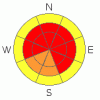
Danger by aspect and elevation on slopes approaching 35° or steeper.
(click HERE for tomorrow's danger rating)
|

Danger Rose Tutorial
|
Bottom Line for the Provo, Salt Lake, and Park City area mountains:
The avalanche danger is HIGH on and below mid and upper elevation slopes, especially those facing west through north through east and southeast. Human triggered avalanche are likely on slopes steeper than about 35 degrees, and slides can be triggered remotely from a distance, so avoid travel adjacent to and below steep avalanche paths. As the winds pick up this afternoon and this evening, a natural avalanche cycle could occur again. Only those people with excellent avalanche skills and experience should travel in the backcountry, and travel should be on gentle slopes and ridge lines well away from avalanche paths. |
|
|
CURRENT CONDITIONS |

|
Skies are overcast, and light snow showers have added a dusting of new snow from about I-80 south. The southerly winds are in the 5 to 15 mph range, with gusts into to the 20's at a few stations. Temperatures remain in the 10 to 15 degree range. Lots of light, soft snow, sitting on a mostly supportable base, provides good turning and riding conditions on low angle slopes. |
|
|
RECENT ACTIVITY |

|
The nightmarish avalanche cycle that started Sunday intensified Tuesday night into yesterday morning. The two standouts were a large natural hard slab that released in Little Cottonwood Canyon at 8:30 am, 4-5' deep, 800' wide on a NE facing slope at 11,000' and a remotely triggered slide in Mineral Fork, that was about 1000' wide on a northeasterly facing slope at about 9,000'. In addition, numerous class 1's and 2's were triggered in the backcountry, many remotely, and most running above the ice crust and explosives in Big Cottonwood Canyon pulled out slides with 2 to 4' crowns. Natural activity was also observed in Cardiff and Days Fork. Check out Bruce's photo gallery and other posted photos. Along the Park City ridge line, Cinder Chutes naturaled, control work produced large slides with ski cuts and explosives, 200 to 250' wide by 2 feet deep, and two slides were triggered remotely by backcountry tourers. Multiple naturals occurred in American Fork on both mid and upper elevation slopes, most widespread on east and northeasterly aspects. |
|
|
THREAT #1 |

|
| WHERE |
PROBABILITY |
SIZE |
TREND |
|
|
|
|
| |
|
|
Over the next
24 hours.
|
|
|
These are the tricky avalanche conditions that could catch and kill a person. Once again, today it will be possible for a person to trigger slides failing on the weak faceted layers above and below the ice crust, both while on a steep slope or remotely from a distance. If it's steep and undisturbed – your weight could make it go. Even “small” 1 to 2 foot deep, 50 foot wide slides are running full track, entraining snow and creating large piles of debris. Almost anywhere there was snow in November, there are sandwiches of weak facets and crusts. Recent profiles of snowpack layering here. Do not be fooled by the absence of cracking and collapsing – you may just be in a well traveled area, or on a used skin track, and the quiet does NOT represent a stable snowpack. Experienced travelers in the backcountry are using their local knowledge to find safe turns on low angle slopes and shallow ridge lines, well away from runout zones. |
|
|
THREAT #2 |

|
| WHERE |
PROBABILITY |
SIZE |
TREND |
|
|
|
|
| |
|
|
Over the next
24 hours.
|
|
|
Increasing winds this afternoon will start to blow and drift the snow. Large quantities of light powder are available for transport, so sensitive drifts will rapidly form along ridges, and cross load around terrain features such as breakovers and subridges. Much of the new wind loading will be on north through easterly facing slopes, and any slide triggered in the sensitive new drifts could break into deeper layers. |
|
|
MOUNTAIN WEATHER |

|
A weather disturbance approaching from the south will bring light snow fall through early afternoon. 3 to 8” of snow is possible today, with the Provo area mountains favored. The winds will blow from the southwest to west, and increase this afternoon. This morning's ridge line speeds of 10 to 20 mph will increase to 20 to 30 mph this afternoon, with gusts in the 40's in exposed terrain. Temperatures will only warm into the mid teens. Strong, southwesterly winds will develop tonight and tomorrow morning ahead of a vigorous cold front which will cross the area Friday afternoon, bringing subzero temperatures and 6 to 12 inches of snow. |
|
|
GENERAL ANNOUNCEMENTS |
If you want to get this avalanche advisory e-mailed to you daily click HERE.
The Wasatch Powderbird Guides - for information, call them at 801-742-2800 or go to their daily blog.
UDOT highway avalanche control work info can be found by calling (801) 975-4838. Our statewide toll free line is 1-888-999-4019 (early morning, option 8).
The UAC depends on contributions from users like you to support our work. To find out more about how you can support our efforts to continue providing the avalanche forecasting and education that you expect please visit our Friends page.
If you’re getting out and see anything we should know about please let us know. You can leave a message at (801) 524-5304 or 1-800-662-4140, or email us at uac@utahavalanchecenter.org. (Fax 801-524-6301).
The information in this advisory is from the U.S. Forest Service, which is solely responsible for its content. This advisory describes general avalanche conditions and local variations always occur.
Bruce Tremper will update this forecast by 7:30 on Friday morning. |
|
|
This information does not apply to developed ski areas or highways where avalanche control is normally done. This advisory is from the U.S.D.A. Forest Service, which is solely responsible for its content. This advisory describes general avalanche conditions and local variations always occur. |
|
This advisory provided by the USDA Forest Service, in partnership with:
The Friends of the Utah Avalanche Center, Utah Division of State Parks and Recreation, Utah Division of Emergency Management, Salt Lake County, Salt Lake Unified Fire Authority and the friends of the La Sal Avalanche Center. See our Sponsors Page for a complete list. |
