| During the month of April, Mark Miller will donate $75 to the charity of your choice (5 to chose from, including the Utah Avalanche Center!) Mark Miller Subaru has raised over $300k in the previous 6 Do Good Feel Good events. More Info here |  |
| During the month of April, Mark Miller will donate $75 to the charity of your choice (5 to chose from, including the Utah Avalanche Center!) Mark Miller Subaru has raised over $300k in the previous 6 Do Good Feel Good events. More Info here | |
| Advisory: Ogden Area Mountains | Issued by Drew Hardesty for Friday - February 27, 2015 - 6:11am |
|---|

|
bottom line We have an overall LOW danger in the Wasatch Range. Minor concerns include dry loose snow avalanches that may move with provocation on the steeper slopes that received the most snow....and any lingering wind pocket from the week's easterly then westerly winds.
|
 |
special announcement Companion Rescue Workshop Join the Utah Avalanche Center and avalanche professionals to hone your partner rescue skills. Curriculum includes scene safety, beacon searching, probing, strategic digging, and packaging and transporting an injured partner. Friday evening (Feb 27 - TONIGHT), Saturday afternoon Mar 7, and Sunday afternoon Mar 8, all at Brighton. More info here Join us at Brighton Mar 7 & 8 for Vertfest! Clinics include Companion Rescue, Terrain Selection, Steep Skiing, and Mountaineering for skiers/split-boarders, both open and women-only. There will also be gear demos and the Wasatch Powder Keg ski mountaineering race, all to benefit the Utah Avalanche Center. More info here. |
 |
current conditions You may have heard about this nifty entrepreneur in Boston shipping snow from his front yard overnight to locations far and wide. Word has it that he's had a number of sales in Utah. We can hold off a bit now that the Wasatch squeezed 7" out of the storm in upper Little Cottonwood and 3-5" in Big Cottonwood and along the Park City ridgeline. A couple inches dot the hillsides of the Ogden and Provo mountains. Densities are a cold-smoke 5%, so you'll be bottom-feeding/dust on crust on all but the untracked and wind affected northerlies. Temps plummeted to the teens; winds are hardly a whisper.
|
 |
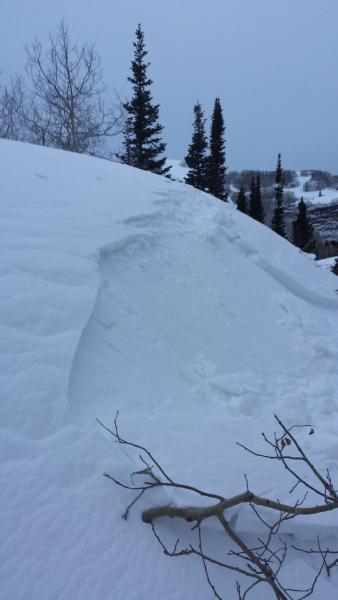
recent activity A couple backcountry skiers initiated a couple loose dry sluffs on some of the steeper northerly terrain on Kessler Peak yesterday while across the street in Mill D North a skier actually cracked out a 4" deep and 15' wide wind pocket on a southeast facing slope at 8700'. I'd imagine more of the same for today.
|
| type | aspect/elevation | characteristics |
|---|

|
|
LIKELIHOOD
 LIKELY
UNLIKELY
SIZE
 LARGE
SMALL
TREND
 INCREASING DANGER
SAME
DECREASING DANGER
|
|
description
During times of Low danger, people often push into more severe and radical terrain. When that's the case, the margin for error can become razor-thin. Remember that even a small sluff coming down from above may be of consequence if you're above no-fall terrain. Same goes for a cranky old shallow wind pocket that you may stumble upon in the more exposed alpine locations. Keep your chin and guard up - risk is always inherent in mountain travel. |
 |
weather We'll have mostly cloudy skies today with perhaps a snowflake or two in the sky. Temps will rise into the upper teens at 10,000', the upper 20s at 8000'. Winds ought to be on their best behavior, blowing 5-10mph along the highest ridgelines. The next storm from the Pacific Northwest arrives late tonight/early morning and persists through Sunday...though it looks to be a southern Utah special, with the bull's eye squarely over the southern San Juans in that state to our east. It's possible we'll pick up a few inches as a consolation prize over the weekend, but I'm already looking toward Tuesday's cold front. At this point, Tuesday looks like mostly cold temps and wind but we may be able to squeeze another few inches out of the system. High pressure builds for mid-week |
| general announcements
Remember your information can save lives. If you see anything we should know about, please participate in the creation of our own community avalanche advisory by submitting snow and avalanche conditions. You can also call us at 801-524-5304, email by clicking HERE, or include #utavy in your tweet or Instagram. If you trigger an avalanche in the backcountry - especially if you are adjacent to a ski area – please call the following teams to alert them to the slide and whether anyone is missing or not. Rescue teams can be exposed to significant hazard when responding to avalanches, and do not want to do so when unneeded. Thanks. Salt Lake and Park City – Alta Central (801-742-2033), Canyons Resort Dispatch (435-615-3322) Snowbasin Resort Dispatch (801-620-1017), Powder Mountain Dispatch (801-745-3772 x 123). Sundance Dispatch (801-223-4150) EMAIL ADVISORY If you would like to get the daily advisory by email you will need to subscribe here. DAWN PATROL Hotline updated daily by 5-530am - 888-999-4019 option 8. Twitter Updates for your mobile phone - DETAILS UDOT canyon closures: LINK TO UDOT, or on Twitter, follow @UDOTavy, @CanyonAlerts or @AltaCentral Utah Avalanche Center mobile app - Get your advisory on your iPhone along with great navigation and rescue tools. Wasatch Powderbird Guides Blog/Itinerary for the Day. Lost or Found something in the backcountry? - http://nolofo.com/ Discount lift tickets are now available at Backcountry.com. Thanks to Ski Utah and the Utah Resorts. All proceeds go towards paying for Utah Avalanche Center avalanche and mountain weather advisories. To those skinning uphill at resorts: it is your responsibility to know the resort policy on uphill travel. You can see the uphill travel policy for each resort here. IMPORTANT: Before skinning or hiking at a resort under new snow conditions, check in with Ski Patrol. Resorts can restrict or cut off access if incompatible with control and grooming operations. Benefit the Utah Avalanche Center when you shop from Backcountry.com or REI: Click this link for Backcountry.com or this link to REI, shop, and they will donate a percent of your purchase price to the UAC. Both offer free shipping (with some conditions) so this costs you nothing! Benefit the Utah Avalanche Center when you buy or sell on ebay - set the Utah Avalanche Center as a favorite non-profit in your ebay account here and click on ebay gives when you buy or sell. You can choose to have your seller fees donated to the UAC, which doesn't cost you a penny. This information does not apply to developed ski areas or highways where avalanche control is normally done. This advisory is from the U.S.D.A. Forest Service, which is solely responsible for its content. This advisory describes general avalanche conditions and local variations always exist. |


_4.jpg)