SPECIAL ANNOUNCEMENT |
 |
We are doing intermittent avalanche advisories, and this forecast covers April 23-25. |
|
|
BOTTOM LINE
Danger by aspect and elevation on slopes approaching 35° or steeper.
(click HERE for tomorrow's danger rating)
|
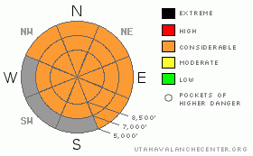
Danger Rose Tutorial
|
Stay off of and out from underneath any steep slopes today. Wet avalanches can occur any time of day but especially in the heat of the afternoon. Conditions will likely not improve until about Thursday. |
|
|
CURRENT CONDITIONS |

|
It's a wee bit hot. The sweltering weather broke many temperature records on Sunday including 68 degrees at Alta. On the Cottonwood Canyons forecast this morning, the forecast high nearly pegs out the temperature graph. The overnight low was 48 degrees at the Alta Guard Station. Hot! |
|
|
RECENT ACTIVITY |
|
|
|
THREAT #1 |

|
| WHERE |
PROBABILITY |
SIZE |
TREND |

|
|
|
|
| |
|
|
Over the next
24 hours.
|
|
|
As you might imagine, wet avalanches will continue today through the next couple days and probably won't calm down until about Thursday when things cool down again. The snowpack is not even refreezing overnight so getting out early might not even help. Stay off of and out from underneath all steep slopes. Period.
Glide avalanches can come down any time of day, even during the night, so definitely avoid all areas where glide avalanches are common such as Stairs Gulch, Broad's Fork and Mill B South. |
|
|
THREAT #2 |

|
| WHERE |
PROBABILITY |
SIZE |
TREND |

|
|
|
|
| |
|
|
Over the next
24 hours.
|
|
|
Cornices are also very soft and expect them to calve off during the day and they may trigger wet avalanches when they do. |
|
|
MOUNTAIN WEATHER |

|
Did I mention it would be hot? The daytime high should be 65-70--yes that's right--70 degrees. Overnight lows will be in the mid to upper 40's. There's enough moisture in the air to boil up some convective clouds over the mountains again complete with the possibility of lightning.
Today should be the hottest day, but we will continue to have hot weather on Tuesday and Wednesday and it won't cool down until Thursday. |
|
|
This information does not apply to developed ski areas or highways where avalanche control is normally done. This advisory is from the U.S.D.A. Forest Service, which is solely responsible for its content. This advisory describes general avalanche conditions and local variations always occur. |
|
This advisory provided by the USDA Forest Service, in partnership with:
The Friends of the Utah Avalanche Center, Utah Division of State Parks and Recreation, Utah Division of Emergency Management, Salt Lake County, Salt Lake Unified Fire Authority and the friends of the La Sal Avalanche Center. See our Sponsors Page for a complete list. |
