SPECIAL ANNOUNCEMENT |
 |
Time is running out and we need your help. We are applying for a competitive grant to help unify our website, email, SMS, and social media alerts, make our site and services more mobile device-friendly, and create an open source platform that could be used by any avalanche center. Check out the link.To get to the next level of competition,we need all of you to click the Like button (follow the link) by the end of Thursday, 3/29. This takes 2 seconds and will have huge results.
http://bit.ly/FRcRsM
Hot tip: we still have some discount lift tickets for Snowbird, Alta, Brianhead, Sundance and Wolf Mountain available through Backcountry.com, which you can find HERE. This is just one of many ways in which we at the UAC stay afloat each winter - Thanks for your support. |
|
|
BOTTOM LINE
Danger by aspect and elevation on slopes approaching 35° or steeper.
(click HERE for tomorrow's danger rating)
|
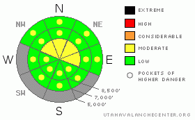
Danger Rose Tutorial
|
The avalanche danger is mostly LOW, with a MODERATE danger remaining on steep, upper elevation, northwest through easterly facing slopes, where in very isolated places a person could still trigger a deeper slab avalanche, likely from a shallow snow pack area. The danger of wet loose sluffs will increase to pockets of MODERATE on most steep slopes as the day heats up. |
|
|
CURRENT CONDITIONS |

|
Last night’s quick moving disturbance has zipped past, leaving 0 to 2” of dense snow in its wake. This morning, under clearing skies, temperatures are still dropping, with most stations around 30 degrees. The winds kicked up briefly from southwest through northwest during the night, gusting into the 30s and 40s. Currently, the northwesterly winds are also decreasing, with 5 to 15 mph averages at all but the highest ridge line stations.
An almost vacant backcountry is allowing the combination of wind and small shots of dense snow to nicely smooth out the snow surface on many slopes, though many sunny lower elevation slopes are melting out to dirt. |
|
|
RECENT ACTIVITY |

|
Swarms of roller balls, both natural and easily initiated, and a few minor wet loose sluffs on steep northerly facing slopes were the only reported avalanche activity yesterday. Cornices were sensitive. |
|
|
THREAT #1 |

|
| WHERE |
PROBABILITY |
SIZE |
TREND |

|
|
|
|
| |
|
|
Over the next
24 hours.
|
|
|
Total confidence in the deeper faceted snowpack layers may never completely return this winter. Approach steep, upper elevation, northerly facing slopes with caution, as avalanches breaking on a deeper layer within the snow pack are still possible in very isolated places. The most suspect slopes are those with a shallow pack, slopes which have already slid this year, or that are very steep and rocky. |
|
|
THREAT #2 |
|
|
|
THREAT #3 |

|
| WHERE |
PROBABILITY |
SIZE |
TREND |
|
|
|
|
| |
|
|
Over the next
12 hours.
|
|
|
With day time heating and sun, the newest snow will become damp, and damp loose snow point releases or large roller balls large enough to push you around will be easy to initiate on steep sunny slopes and low to mid elevation northerly facing slopes which received 2 or 3 “ of new snow. Once the new snow heats up, it is time to stay off steep slopes and out of gullies, couloirs and creek beds. |
|
|
MOUNTAIN WEATHER |

|
Last evening’s small storm is exiting stage right, and will be replaced with sunny skies this morning. In the afternoon, there will be increasing high to mid level clouds. Temperatures will start to climb, into the low to mid 40’s at 8,000’ and to near freezing along the ridge lines. The westerly winds will decrease today, into the 5 to 15 mph range, and gradually shift to the southwest by this evening. Occasional wind gusts into the 30s are possible across the highest ridges today. A series of increasingly warm days will culminate Saturday, with 10,000’ highs in the low 40s and strong southwesterly winds. A quick moving, colder storm will cross the area Saturday night or Sunday, with preliminary snow estimates in the 6 to 10” range. |
|
|
GENERAL ANNOUNCEMENTS |
If you trigger an avalanche in the backcountry - especially if you are adjacent to a ski area – please call the following teams to alert them to the slide and whether anyone is missing or not. Rescue teams can be exposed to significant hazard when responding to avalanches, and do not want to do so when unneeded. Thanks.
Salt Lake and Park City – Alta Central (801-742-2033)
Ogden – Snowbasin Patrol Dispatch (801-620-1017)
Provo – Sundance Patrol Dispatch (801-223-4150)
Dawn Patrol Forecast Hotline, updated by 05:30: 888-999-4019 option 8.
Twitter Updates for your mobile phone http://utahavalanchecenter.org/twitter)
Daily observations are frequently posted by 10 pm each evening.
Subscribe to the daily avalanche advisory e-mail click HERE.
UDOT canyon closures UDOT at (801) 975-4838
Wasatch Powderbird Guides does daily updates about where they'll be operating on this blog http://powderbird.blogspot.com/.
Remember your information can save lives.If you see anything we should know about, please participate in the creation of our own community avalanche advisory by submitting avalanche and snow observations. You can also call us at 801-524-5304 or 800-662-4140, or email by clicking HERE
Donate to your favorite non-profit –The Friends of the Utah Avalanche Center. The UAC depends on contributions from users like you to support our work.
We will update this forecast tomorrow morning. Thanks for calling. |
|
|
This information does not apply to developed ski areas or highways where avalanche control is normally done. This advisory is from the U.S.D.A. Forest Service, which is solely responsible for its content. This advisory describes general avalanche conditions and local variations always occur. |
|
This advisory provided by the USDA Forest Service, in partnership with:
The Friends of the Utah Avalanche Center, Utah Division of State Parks and Recreation, Utah Division of Emergency Management, Salt Lake County, Salt Lake Unified Fire Authority and the friends of the La Sal Avalanche Center. See our Sponsors Page for a complete list. |