SPECIAL ANNOUNCEMENT |
 |
Time is running out and we need your help. We are applying for a competitive grant to help unify our website, email, SMS, and social media alerts, make our site and services more mobile device-friendly, and create an open source platform that could be used by any avalanche center. Check out the link.To get to the next level of competition,we need all of you to click the Like button (follow the link) by the end of Thursday, 3/29. This takes 2 seconds and will have huge results.
http://bit.ly/FRcRsM
Hot tip: we still have some discount lift tickets for Snowbird, Alta, Brianhead, Sundance and Wolf Mountain available through Backcountry.com, which you can find HERE. This is just one of many ways in which we at the UAC stay afloat each winter - Thanks for your support. |
|
|
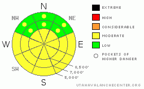
BOTTOM LINE
Danger by aspect and elevation on slopes approaching 35° or steeper.
(click HERE for tomorrow's danger rating)
|
Danger Rose Tutorial
|
Pockets of MODERATE danger exist for lingering wind drifts with a MODERATE danger for lingering persistent/deep slab issues. Both are more pronounced in the steep upper elevation shady terrain. The danger for wet avalanche activity will again rise to MODERATE with daytime heating. |
|
|
CURRENT CONDITIONS |

|
Skies are clear to partly cloudy. Current and overnight lows are in the upper 20s. The southerly winds along the exposed ridgelines increased to 45mph with gusts to 50. Riding conditions were fair and creamy on upper elevation low angle slopes. Still easy to go over the handlebars with frozen chicken heads and roller balls just beneath the now settled couple inches from Monday's "storm". |
|
|
RECENT ACTIVITY |

|
Localized shallow wind slab and minor wet activity rounded out the news from the backcountry yesterday. Looking to the way north, however, take a moment to check out the wet slab activity in Montana at the Bridger Bowl and Yellowstone Club ski areas. (Video, Photos) |
|
|
THREAT #1 |

|
| WHERE |
PROBABILITY |
SIZE |
TREND |

|
|
|
|
| |
|
|
Over the next
10 hours.
|
|
|
Cracking and shallow wind slab were found in pockets of the high lee northerly terrain as well as cross loaded on southerly and off aspects. The new snow bonded fairly well to the old locked up frozen corrugated snow surface; however, isolated drifts today may still be sensitive to human weight, particularly with today's sun and heat.
There's little snow to blow around after yesterday's warming; though time and time again I underestimate the wind's ability to erode crust, find its own secret stashes to move snow, or cross-load into odd terrain. Any pockets will be quite small and manageable, though worth a thought in unforgiving terrain. |
|
|
THREAT #2 |

|
| WHERE |
PROBABILITY |
SIZE |
TREND |

|
|
|
|
| |
|
|
Over the next
24
hours.
|
|
|
The last persistent and deep slab releases in the backcountry occurred just a week ago during and just after the Equinox storm. They've been reactive this month with significant weather events - rapid warming (March 4) and heavy snow and wind (Equinox). Human triggering remains unlikely, though possible in the upper elevation shady terrain with a thin rocky snowpack (to include terrain that has avalanched previously this season).
How do you know if it's avalanched previously? I often pull out my probe to check snowpack depths and structure. Yellow flag depths would be 120cm (4') or less. Red flag structure - you can insert the probe and feel varying degrees of resistance until you hit the ground. This year you can push through the few winter storm 'slabs' - these offer quite a bit of resistance - then almost fall on top of your probe as it cuts through the basal depth hoar like butter. Not good. Or take a quick look at Ted Scroggin's fine example from the Uintas a couple days ago. |
|
|
THREAT #3 |

|
| WHERE |
PROBABILITY |
SIZE |
TREND |

|
|
|
|
| |
|
|
Over the next
10 hours.
|
|
|
With regards to sun and heating today, graupel and high density snow with a decent bond to the old snow surface isn't the same as cold smoke on an ice crust. Still, I'd expect some roller balls and loose wet sluffs in the steep sun-lit terrain. Wet-push-alanches are also likely with provocation - intentional or otherwise.
Slide for life conditions still exist in the steep scoured still-frozen terrain. |
|
|
MOUNTAIN WEATHER |

|
We'll have partly-leading-to-mostly-cloudy skies ahead of a weak storm expected to move through northern Utah tonight. Ahead of the disturbance, we'll have 8000' temps rising to the upper 40s with winds blowing 25-30mph from the south and southwest. We may get lucky to squeeze an inch or two out of the event. The next few days provide a warm westerly flow with the next storm arriving late Saturday into Sunday. Looks like a quick hitter but should offer a few inches of snow. |
|
|
GENERAL ANNOUNCEMENTS |
If you trigger an avalanche in the backcountry - especially if you are adjacent to a ski area – please call the following teams to alert them to the slide and whether anyone is missing or not. Rescue teams can be exposed to significant hazard when responding to avalanches, and do not want to do so when unneeded. Thanks.
Salt Lake and Park City – Alta Central (801-742-2033)
Ogden – Snowbasin Patrol Dispatch (801-620-1017)
Provo – Sundance Patrol Dispatch (801-223-4150)
Dawn Patrol Forecast Hotline, updated by 05:30: 888-999-4019 option 8.
Twitter Updates for your mobile phone http://utahavalanchecenter.org/twitter)
Daily observations are frequently posted by 10 pm each evening.
Subscribe to the daily avalanche advisory e-mail click HERE.
UDOT canyon closures UDOT at (801) 975-4838
Wasatch Powderbird Guides does daily updates about where they'll be operating on this blog http://powderbird.blogspot.com/.
Remember your information can save lives.If you see anything we should know about, please participate in the creation of our own community avalanche advisory by submitting avalanche and snow observations. You can also call us at 801-524-5304 or 800-662-4140, or email by clicking HERE
Donate to your favorite non-profit –The Friends of the Utah Avalanche Center. The UAC depends on contributions from users like you to support our work.
We will update this forecast tomorrow morning. Thanks for calling. |
|
|
This information does not apply to developed ski areas or highways where avalanche control is normally done. This advisory is from the U.S.D.A. Forest Service, which is solely responsible for its content. This advisory describes general avalanche conditions and local variations always occur. |
|
This advisory provided by the USDA Forest Service, in partnership with:
The Friends of the Utah Avalanche Center, Utah Division of State Parks and Recreation, Utah Division of Emergency Management, Salt Lake County, Salt Lake Unified Fire Authority and the friends of the La Sal Avalanche Center. See our Sponsors Page for a complete list. |
