SPECIAL ANNOUNCEMENT |
 |
We need your help! Would you like a great mobile avalanche app? A new, slick website look? A better, easier-to-use information network? And something that all avalanche centers can us?. There could be an app for that.
We are applying for a grant to help unify our website, email, SMS, and social media alerts and create an open source platform that could be used by any avalanche center. Check out the link. Click the Like button to vote for the project and spread this among your friends. The grant is awarded based on the number of votes:
http://bit.ly/FRcRsM |
|
|
BOTTOM LINE
Danger by aspect and elevation on slopes approaching 35° or steeper.
(click HERE for tomorrow's danger rating)
|
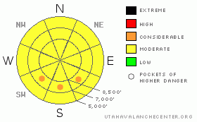
Danger Rose Tutorial
|
Get out early and get off of--and out from underneath--steep, sun exposed slopes by noon.
The danger from wet avalanches should quickly rise from Low this morning to Moderate with pockets of Considerable by afternoon.
It's still possible to trigger a deep, large avalanche (low probability - high consequence) on steep, northwest, north, northeast and east facing slopes above about 9,500'. Continue to choose conservative terrain in these areas based on steepness and consequences. |
|
|
CURRENT CONDITIONS |

|
Spring has sprung and you can tell--strong sun, warm temperatures crusty snow and rollerballs. Temperatures are a few degrees warmer this morning than yesterday morning and the daytime highs should be 3-4 degrees warmer too. This morning, there should be a thin refreeze of the snow surface. It's 26 degrees and it should rise to 40 degrees today. Winds have picked up a bit from the south and should blow 15 mph today.
Snow surface conditions include sun crust on all aspects except there is still some soft, settled powder on straight north facing slopes above about 9,000'. I would guess there may be some supportable, immature corn on south faces this morning but should turn to glop again by mid morning. |
|
|
RECENT ACTIVITY |

|
There was no significant activity from the backcountry yesterday but there was a significant deep slab released by explosives in upper Little Cottonwood Canyon. It was 5-7' deep, 400' wide, 10,400' elevation on a steep N-NW facing slope under cliffs. It ran to the flats. Yikes! |
|
|
THREAT #1 |

|
| WHERE |
PROBABILITY |
SIZE |
TREND |

|
|
|
|
| |
|
|
Over the next
11 hours.
|
|
|
Yesterday, the snow quickly turned to mashed potatoes by noon and should do so again today. There were quite a few rollerballs but no wet slabs we saw or heard about. Today we should have slightly warmer temperatures than yesterday but I'm thinking they will be balanced out by a bit stronger south winds today along with some high and mid elevation clouds arriving by afternoon.
Wet avalanche activity is always very difficult to forecast but I'm guessing it should be about like yesterday with occasional sluffs in the heat of the afternoon on steep, sun exposed slopes. Most of the problems will be on southwest through southeast facing slopes between about 8,000' and 10,000'. The sunny slopes are mostly bare below 7,500'.
As always this time of year, get out early and get off the steep sun exposed slopes by noon. |
|
|
THREAT #2 |

|
| WHERE |
PROBABILITY |
SIZE |
TREND |

|
|
|
|
| |
|
|
Over the next
24 hours.
|
|
|
Yesterday's deep release by explosives is proof that the monsters in the basement will never go away this season. It's a Dirty Harry snowpack. These low probability - high consequence avalanches are impossible to predict and provide no clues to their presence. So how lucky do you feel?
The pattern we see is thin snowpack areas on steep northwest, north and northeast facing slopes above about 9,000'. Be especially suspicious of slopes that slid deep earlier in the season where you should continue to choose conservative terrain based on steepness and consequences. |
|
|
MOUNTAIN WEATHER |

|
Leave your long underwear at home. Wear a white shirt, brimmed hat and lots of sunscreen--yup, sounds like spring. We should have sunny skies with some high and possibly mid elevation clouds by afternoon. Ridge top temperatures should be over 40 degrees with 50 degrees down at 8,000'. The wind has picked up a bit and should blow from the south 15 mph.
We should continue with warm weather on Friday and Saturday with stronger wind from the south. Then, we have a weak storm for Sunday and Monday, which should cool things down quite a bit with a few inches of snow. |
|
|
GENERAL ANNOUNCEMENTS |
GENERAL ANNOUNCEMENTS
If you trigger an avalanche in the backcountry - especially if you are adjacent to a ski area – please call the following teams to alert them to the slide and whether anyone is missing or not. Rescue teams can be exposed to significant hazard when responding to avalanches, and do not want to do so when unneeded. Thanks.
Salt Lake and Park City – Alta Central (801-742-2033)
Ogden – Snowbasin Patrol Dispatch (801-620-1017)
Provo – Sundance Patrol Dispatch (801-223-4150)
Dawn Patrol Forecast Hotline, updated by 05:30: 888-999-4019 option 8.
Twitter Updates for your mobile phone http://utahavalanchecenter.org/twitter)
Daily observations are frequentlypostedby 10 pm each evening.
Subscribe to the daily avalanche advisory e-mail clickHERE.
UDOT canyon closuresUDOTat (801) 975-4838
Wasatch Powderbird Guides does daily updates about where they'll be operating on this blog http://powderbird.blogspot.com/.
Remember your information can save lives.If you see anything we should know about, please participate in the creation of our own community avalanche advisory by submitting avalanche and snow observations. You can also call us at 801-524-5304 or 800-662-4140, or email by clicking HERE
Donate to your favorite non-profit –The Friends of the Utah Avalanche Center. The UAC depends on contributions from users like you to support our work.
We will update this forecast tomorrow morning. Thanks for calling. |
|
|
This information does not apply to developed ski areas or highways where avalanche control is normally done. This advisory is from the U.S.D.A. Forest Service, which is solely responsible for its content. This advisory describes general avalanche conditions and local variations always occur. |
|
This advisory provided by the USDA Forest Service, in partnership with:
The Friends of the Utah Avalanche Center, Utah Division of State Parks and Recreation, Utah Division of Emergency Management, Salt Lake County, Salt Lake Unified Fire Authority and the friends of the La Sal Avalanche Center. See our Sponsors Page for a complete list. |
