SPECIAL ANNOUNCEMENT |
 |
Check out the Online store above for ski passes - there are still weeks of great spring skiing left, and perhaps a few powder storms still coming. All proceeds go to our partner the Friends of the Utah Avalanche Center. |
|
|
BOTTOM LINE
Danger by aspect and elevation on slopes approaching 35° or steeper.
(click HERE for tomorrow's danger rating)
|
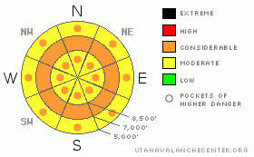
Danger Rose Tutorial
|
Pockets of Considerable danger exist on all aspects and elevations for human triggered wet sluffs and damp slabs. With daytime warming and additional rain, the danger will rise to Considerable. Natural wet sluffs gouging to the ground are also possible, particularly in thinner, saturated snowpack areas. Sagging cornices should be avoided. a
|
|
|
CURRENT CONDITIONS |

|
After a winter of beginning the forecasts with ‘Skies are clear’…I can now offer that skies are overcast with precipitation described as a rain/snow mix. The large scale storm engulfing most of the western US is nearly upon us. Temps hover at freezing along the ridgelines and continue to bask (swelter?) in the upper 30s and low 40s at the mid to low elevations. Winds remain moderate to strong out of the south. Snow conditions are relatively poor, with soon to soften crusts at the higher elevations and unsupportable glop nearly everywhere else.
|
|
|
RECENT ACTIVITY |

|
We heard of some wet loose snow avalanches gouging to the ground along the northern periphery of Snowbasin, leaving some impressive debris piles in the gullies below. Other reports have come in from slides on Thursday – wet loose sluffs triggering 1-3’ deep slabs, running on damp depth hoar, facets, or surface hoar below. (West Monitor, South of Strawberry near Snowbasin, near Logan Peak). These were on steep northeast to east facing slopes on elevations of 7500’, 8500’, and 9500’.
|
|
|
THREAT #1 |

|
| WHERE |
PROBABILITY |
SIZE |
TREND |

|
|
|
|
| |
|
|
Over the next
12 hours.
|
|
|
Much of the isothermal snowpack at the mid and low elevations have suffered the last number of days (depending on where you’re looking March 12 in the central Wasatch, March 10 in Ogden and Provo) with no refreeze…meaning free water starts to percolate through the snowpack, often resulting in wet sluff and wet slab avalanches. (See our Electric Kool-Aid trick from yesterday). This pattern will continue into today. Much of the southerly aspects have already suffered the sun and temps…whereas now most of the northwesterly to northerly to easterly aspects are starting to become damp and unstable. Still – the bottom line for me - this many nights with little to no refreeze drives route selection on low angle – or compacted (ie – ski area) terrain.
Remember these wet avalanches, while slower than their distant dry cousins, sets up like concrete in the debris piles.
|
|
|
THREAT #2 |

|
| WHERE |
PROBABILITY |
SIZE |
TREND |

|
|
|
|
| |
|
|
Over the next
24 hours.
|
|
|
It’s a matter of increased stress and/or decreased strength. In this case, it’s both. The three slabs triggered by loose wet sluffs on Thursday all ran on faceted snow (depth hoar, faceted snow or surface hoar) with varying degrees (including none) of free water present along the weakness. Many will behave as persistent slabs (triggered by people or other wet sluffs), many will behave as wet slabs.
|
|
|
MOUNTAIN WEATHER |

|
We’ll see most of the weekend’s precipitation coming in on a south to southwesterly flow today and tomorrow. A rain snow line of 9500’ will drop to 6000’ tomorrow. Still, this flow favors the Provo mountains, upper BCC, and the southern PC mountains. Ogden as well. We may see a few inches overnight, a few more tomorrow with more snow on the way Monday into Tuesday. Temps will rise to the mid 40s at 8000’, the upper 30s at 10,000’. Winds will be strong from the south. The storm will persist through early Wednesday and we may see 12-18” in favored areas by then.
|
|
|
GENERAL ANNOUNCEMENTS |
If you trigger an avalanche in the backcountry - especially if you are adjacent to a ski area – please call the following teams to alert them to the slide and whether anyone is missing or not. Rescue teams can be exposed to significant hazard when responding to avalanches, and do not want to do so when unneeded. Thanks.
Salt Lake and Park City – Alta Central (801-742-2033)
Ogden – Snowbasin Patrol Dispatch (801-620-1017)
Provo – Sundance Patrol Dispatch (801-223-4150)
Dawn Patrol Forecast Hotline, updated by 05:30: 888-999-4019 option 8.
Twitter Updates for your mobile phone http://utahavalanchecenter.org/twitter)
Daily observations are frequentlypostedby 10 pm each evening.
Subscribe to the daily avalanche advisory e-mail clickHERE.
UDOT canyon closuresUDOTat (801) 975-4838
Wasatch Powderbird Guides does daily updates about where they'll be operating on this blog http://powderbird.blogspot.com/.
Remember your information can save lives.If you see anything we should know about, please participate in the creation of our own community avalanche advisory by submittingavalanche and snow observations. You can also call us at 801-524-5304 or 800-662-4140, or email by clickingHERE
Donate to your favorite non-profit –The Friends of the Utah Avalanche Center. The UAC depends on contributions from users like you to support our work.
We will update this forecast tomorrow morning. Thanks for calling. |
|
|
This information does not apply to developed ski areas or highways where avalanche control is normally done. This advisory is from the U.S.D.A. Forest Service, which is solely responsible for its content. This advisory describes general avalanche conditions and local variations always occur. |
|
This advisory provided by the USDA Forest Service, in partnership with:
The Friends of the Utah Avalanche Center, Utah Division of State Parks and Recreation, Utah Division of Emergency Management, Salt Lake County, Salt Lake Unified Fire Authority and the friends of the La Sal Avalanche Center. See our Sponsors Page for a complete list. |
