AVALANCHE WARNING »
Dangerous avalanche conditions are occuring or are imminent.
Backcountry travel in avalanche terrain is not recommended.
|
 |
Notice: An Avalanche Warning continues in effect for the mountains of northern and central Utah. Continued snow and wind will keep avalanche conditions Considerable to High. |
|
|
BOTTOM LINE
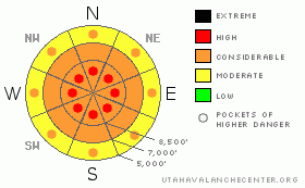
Danger by aspect and elevation on slopes approaching 35° or steeper.
(click HERE for tomorrow's danger rating)
|

Danger Rose Tutorial
|
Definitely stay off of, and out from underneath, all slopes approaching 34 degrees or steeper.
The avalanche danger is CONSIDERABLE with pockets of HIGH danger. I wish I could tell you where those pockets are located, but the snowpack is extremely complex and variable. Choosing conservative terrain remains the only mitigation choice right now, which means stay on slopes of 30 degrees or less. |
|
|
CURRENT CONDITIONS |

|
It finally seems like a normal winter. I shoveled more snow this morning than I have all winter. And we have a good, old-fashioned, cold, northwest flow--just like the old days. Northwest flows favor Upper Little Cottonwood Canyon, lower to mid Big Cottonwood Canyon, Ben Lomond Peak and the Wellsville Mountains. Upper Little Cottonwood Canyon has 13-17 inches so far. Temperatures are around 5 degrees. The snow is low density. Yup, today would be a great call-in-sick day. |
|
|
RECENT ACTIVITY |

|
Yesterday, there were a number of significant avalanches as well as 4 skier triggered slides. All of these happened in the Salt Lake area mountains. There was a humumgous avalanche in south Monitor along the Park City ridgeline that ran Wednesday morning. It broke out about 6’ deep and 1000’ wide and broke full depth, taking out the entire season’s snowpack. Yikes! (See complete report with photos). All the other avalanches ran just within the new snow. There was a remote triggered slide in Meadow Chutes, what appeared to be a snowboarder triggered slide in the Canyons sidecountry, an intentionally-triggered slide 2-3’ x 400’ in the Brighton sidecountry and an unintentionally-triggered slide next to it 3’ x 20’, which pushed the lone skier into a tree but luckily he was not carried down the slope or injured. In addition, there was a number of other significant releases noted within the new snow. See our Current Conditions section for more details. |
|
|
THREAT #1 |

|
| WHERE |
PROBABILITY |
SIZE |
TREND |

|
|
|
|
| |
|
|
Over the next
24
hours.
|
|
|
I'm going to lump persistent slabs and deep slabs together here because it's getting hard to differentiate them. Yesterday, many of the avalanches that appeared to involve just the new snow seemed to be sliding on some kind of faceted layer on the old snow surface, which is the reason they are as sensitive and persistent as they are.
Then, there's the south Monitor slide, which says it all. We have not seen full depth avalanches for several weeks in the Wasatch Range, so this is a great example that monsters in the basement get cranky when subjected to rapid change, especially rapidly-loaded weight of wind blown snow and new snow. We've had 40 inches of snow in the last several days with 2.5 inches of water weight. The obvious question is what's next? South Monitor went naturally just before its identical twin brother, Dutch Draw, was tracked out wall to wall. I don't know about you, but I'm not fond of Russian Roulette. |
|
|
THREAT #2 |

|
| WHERE |
PROBABILITY |
SIZE |
TREND |

|
|
|
|
| |
|
|
Over the next
24
hours.
|
|
|
Today's new snow is light and not as slabby as yesterday's snow, but with all the new snow over the past several days, you have to expect continued new snow slabs that could involve several day's worth of snow. Many of these yesterday were breaking 2-3 feet, which is a very large avalanche. |
|
|
MOUNTAIN WEATHER |

|
The snow should be mostly over and we should have light snow flurries today with even the sun poking through at times. It will remain cold in the lower teens today and the winds should come up from the northwest later in the day blowing 20, gusting to 30, which could blow some snow around.
We should have another nice day on Saturday, with some rapid warming on Sunday. We have chance for more snow on Wednesday. |
|
|
GENERAL ANNOUNCEMENTS |
If you trigger an avalanche in the backcountry - especially if you are adjacent to a ski area – please call the following teams to alert them to the slide and whether anyone is missing or not. Rescue teams can be exposed to significant hazard when responding to avalanches, and do not want to do so when unneeded. Thanks.
Salt Lake and Park City – Alta Central (801-742-2033)
Ogden – Snowbasin Patrol Dispatch (801-620-1017)
Provo – Sundance Patrol Dispatch (801-223-4150)
Dawn Patrol Forecast Hotline, updated by 05:30: 888-999-4019 option 8.
Twitter Updates for your mobile phone http://utahavalanchecenter.org/twitter)
Daily observations are frequently posted by 10 pm each evening.
Subscribe to the daily avalanche advisory e-mail click HERE.
UDOT canyon closures UDOT at (801) 975-4838
Wasatch Powderbird Guides does daily updates about where they'll be operating on this blog http://powderbird.blogspot.com/ .
You have the opportunity to participate in the creation of our own community avalanche advisory by submitting avalanche and snow observations. You can also call us at 801-524-5304 or 800-662-4140, or email by clicking HERE
Donate to your favorite non-profit –The Friends of the Utah Avalanche Center. The UAC depends on contributions from users like you to support our work.
We will update this forecast tomorrow morning. Thanks for calling. |
|
|
This information does not apply to developed ski areas or highways where avalanche control is normally done. This advisory is from the U.S.D.A. Forest Service, which is solely responsible for its content. This advisory describes general avalanche conditions and local variations always occur. |
|
This advisory provided by the USDA Forest Service, in partnership with:
The Friends of the Utah Avalanche Center, Utah Division of State Parks and Recreation, Utah Division of Emergency Management, Salt Lake County, Salt Lake Unified Fire Authority and the friends of the La Sal Avalanche Center. See our Sponsors Page for a complete list. |

