BOTTOM LINE
Danger by aspect and elevation on slopes approaching 35° or steeper.
(click HERE for tomorrow's danger rating)
|
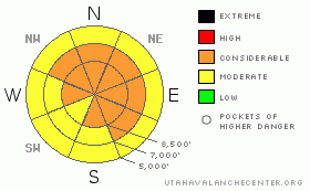
Danger Rose Tutorial
|
Dangerous avalanche conditions exist in the backcountry – there is a CONSIDERABLE avalanche danger on most slopes approaching 35 degrees and steeper at the mid and upper elevations, especially those with new drifts of wind blown snow. Avoid travel on and below steep slopes, as avalanches can be triggered remotely from a distance.
Use cautious route finding and conservative decision making. Low angle slopes that are not connected to or beneath steep slopes provide the safer terrain today. |
|
|
CURRENT CONDITIONS |

|
It has taken most of the night for the punishing winds to decrease into moderate territory. Currently, they are blowing from the west to northwest in the 10 to 15 mph range, gusting to 30. Temperatures have dipped into the single digits in the Ogden area mountains, and are in the teens at the mid and lower elevations. While hard to measure due to the wind, the most parts of the Ogden mountains received approximately 1 to 2” of snow yesterday and overnight.
Reports continue to be of good turning and riding on low angle slopes in dense snow in spite of the wind. |
|
|
RECENT ACTIVITY |

|
Few people braved the blustery storm yesterday, but most of those who did reported collapsing on mid and upper elevation slopes, including slopes facing east through south through southwest. Avalanche wise:
· Snowmobilers triggered a hard slab remotely from the ridgeline on south facing Sunset peak that was 3 to 4' deep.
· Along the Park City ridgeline – 2 naturals were observed early in the morning in heavily wind drifted chutes, 18-24” deep by 100’ wide, running about 500’.
· Shallow wind drifts were easy to trigger. |
|
|
THREAT #1 |

|
| WHERE |
PROBABILITY |
SIZE |
TREND |
|
|
|
|
| |
|
|
Over the next
12 hours.
|
|
|
There are now so many faceted and persistent weak layers buried in the snow pack, that even if we had x-ray vision, we might be overwhelmed by the erratic distribution of all the different layers by both aspect and elevation. In some ways this unpredictable, inconsistency simplifies the problem - avoid all steep slopes, especially if they are recently wind drifted. The strength of the weak layer can vary over such a short distance, that specific snowpack evaluation is hard. A slide you trigger can be 3 to 5 feet deep, breaking near the ground, or 1 to 2 feet deep, failing on buried surface hoar, small facets or in facets associated with one of a number of crusts. Slopes with a thin snowpack, including those that have slid one or more time this year, generally have the weakest snow. And slides can be triggered remotely from a distance, from above, to the side of below.
Orum/Pollick photo - Buried surface hoar in the Ogden area mountains.

|
|
|
THREAT #2 |

|
| WHERE |
PROBABILITY |
SIZE |
TREND |
|
|
|
|
| |
|
|
Over the next
12 hours.
|
|
|
The mountains had almost 24 hours of pounding winds - shifting from south to west and then to northwest. Snow drifted and formed sensitive slabs at most elevations and on a wide variety of aspects. These drifts may actually be less common right along the usual ridgeline locations, with more loading having occurred mid slope, around steep breakovers and along gully walls.
Drew's photo below - Mill D north, Big Cottonwood They will be more stubborn today, and their scattered location means you may stumble into one when you least expect. They will be more stubborn today, and their scattered location means you may stumble into one when you least expect. |
|
|
MOUNTAIN WEATHER |

|
The storm is exiting the region this morning, and weak high pressure will build in, with decreasing winds through out the day and skies becoming partly cloudy. Temperatures will slowly warm into the low 20s at 8,000’ and into the low teens at 10,000’. The westerly winds will gradually drop into the 5 to 15 mph range, though gusts to 45 mph are still possible across the higher ridges this morning. The next storm will arrive Monday afternoon or evening, with strong, southwesterly winds ahead of the front once again, starting tonight. This storm has potential for 6 to 12 inches of snow. |
|
|
GENERAL ANNOUNCEMENTS |
If you trigger an avalanche in the backcountry - especially if you are adjacent to a ski area – please call the following teams to alert them to the slide and whether anyone is missing or not. Rescue teams can be exposed to significant hazard when responding to avalanches, and do not want to do so when unneeded. Thanks.
Salt Lake – Alta Central (801-742-2033)
Ogden – Snowbasin Patrol Dispatch (801-620-1017)
Provo – Sundance Patrol Dispatch (801-223-4150)
Dawn Patrol Forecast Hotline, updated by 05:30: 888-999-4019 option 8.
Twitter Updates for your mobile phone http://utahavalanchecenter.org/twitter)
Daily observations are frequently posted by 10 pm each evening.
Subscribe to the daily avalanche advisory e-mail click HERE.
UDOT canyon closures UDOT at (801) 975-4838
Wasatch Powderbird Guides does daily updates about where they'll be operating on this blog http://powderbird.blogspot.com/ .
You have the opportunity to participate in the creation of our own community avalanche advisory by submitting avalanche and snow observations. You can also call us at 801-524-5304 or 800-662-4140, or email by clicking HERE
Donate to your favorite non-profit –The Friends of the Utah Avalanche Center. The UAC depends on contributions from users like you to support our work.
We will update this forecast tomorrow morning. Thanks for calling. |
|
|
This information does not apply to developed ski areas or highways where avalanche control is normally done. This advisory is from the U.S.D.A. Forest Service, which is solely responsible for its content. This advisory describes general avalanche conditions and local variations always occur. |
|
This advisory provided by the USDA Forest Service, in partnership with:
The Friends of the Utah Avalanche Center, Utah Division of State Parks and Recreation, Utah Division of Emergency Management, Salt Lake County, Salt Lake Unified Fire Authority and the friends of the La Sal Avalanche Center. See our Sponsors Page for a complete list. |
