AVALANCHE WARNING »
Dangerous avalanche conditions are occuring or are imminent.
Backcountry travel in avalanche terrain is not recommended.
|
 |
Notice:
I have continued the avalanche warning for the mountains of northern and central Utah. Tricky and dangerous avalanche conditions will continue today on many slopes. People without expert level avalanche skills should avoid slopes approaching 35 degrees or steeper and stay out from underneath steep slopes. |
|
|
SPECIAL ANNOUNCEMENT |
 |
UDOT Avalanche Control 2/24/12: Backcountry closed in Big Cottonwood Canyon on South side from Cardiff Fork. through Stairs. Road Closure 8:00 to 8:30am Closure Time: Friday, February 24, 2012 - 12:00am Anticipated Re-Opening: Friday, February 24, 2012 - 9:00am |
|
|
BOTTOM LINE
Danger by aspect and elevation on slopes approaching 35° or steeper.
(click HERE for tomorrow's danger rating)
|
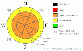
Danger Rose Tutorial
|
Very tricky, complex avalanche conditions exist today. If you don't have expert level avalanche skills and training, you should avoid all slopes approaching 35 degrees or steeper and stay out from underneath steep slopes.
There is a mostly CONSIDERABLE avalanche danger today with pockets of HIGH danger. |
|
|
CURRENT CONDITIONS |

|
It's still cold and breezy this morning but temperatures will rapidly warm today. Skies are clear. The riding conditions are quite challenging with dense, stiff, wind slabs at most all elevations and icy conditions at low elevations. |
|
|
RECENT ACTIVITY |

|
It was a wild day yesterday. One tragic fatality occurred in Dutch Draw, the backcountry near Canyon Resort. You can read our preliminary report and Evelyn will visit the site today and gather more details. There was widespread, large, results from avalanche control yesterday especially in Little Cottonwood Canyon, which you can read HERE. In addition, there were some remotely-triggered avalanches and large collapses. Click HERE for a good report from Mark White. |
|
|
THREAT #1 |

|
| WHERE |
PROBABILITY |
SIZE |
TREND |

|
|
|
|
| |
|
|
Over the next
24
hours.
|
|
|
It's an extremely complex avalanche situation. I can count 4 different kinds of avalanche problems you will encounter today, each one with it's own pattern. There are 1) lingering, graupel wind slabs, 2) collapsing onto a rime crust and near surface facets, 3) deep slab potential and 4) wet avalanches on low elevation sunny slopes with rapid warming. It all makes my head spin. If I'm confused, I bet others will have a hard time sorting it all out as well.
I'll start out with the persistent weak layers: There is faceted snow around a rime crust about a foot deep and maybe some surface hoar thrown in for laughs. Then there is our old friend, the depth hoar near the ground. Some of the avalanches yesterday broke to one or more of these layers and they may do so again today. |
|
|
THREAT #2 |

|
| WHERE |
PROBABILITY |
SIZE |
TREND |

|
|
|
|
| |
|
|
Over the next
24
hours.
|
|
|
There was widespread, dense, wind slabs created yesterday by dense snow and very strong winds. Most of these will have settled out with the cold temperatures but with rapid warming today, it may reactivate them. |
|
|
THREAT #3 |

|
| WHERE |
PROBABILITY |
SIZE |
TREND |

|
|
|
|
|
|
Today's rapid warming and strong sun will likely create some wet activity on the lower elevation, sun exposed slopes. |
|
|
MOUNTAIN WEATHER |

|
Confusing, unsettled weather creates confusing, unsettled avalanche conditions. Today should be mostly sunny with enough low elevation moisture to create some clouds around the mountains. Temperatures will rapidly warm today from near zero this morning to near freezing by afternoon.
Then, we have yet another small, windy storm for Saturday. Strong, southwest ridge top winds will start blowing Friday night with perhaps 4 inches of snow on Saturday.
Then, we have a stronger-looking storm expected on Monday night and another one later in the week. |
|
|
GENERAL ANNOUNCEMENTS |
If you trigger an avalanche in the backcountry - especially if you are adjacent to a ski area – please call the following teams to alert them to the slide and whether anyone is missing or not. Rescue teams can be exposed to significant hazard when responding to avalanches, and do not want to do so when unneeded. Thanks.
Salt Lake – Alta Central (801-742-2033)
Ogden – Snowbasin Patrol Dispatch (801-620-1017)
Provo – Sundance Patrol Dispatch (801-223-4150)
Dawn Patrol Forecast Hotline, updated by 05:30: 888-999-4019 option 8.
Twitter Updates for your mobile phone http://utahavalanchecenter.org/twitter)
Daily observations are frequently posted by 10 pm each evening.
Subscribe to the daily avalanche advisory e-mail click HERE.
UDOT canyon closures UDOT at (801) 975-4838
Wasatch Powderbird Guides does daily updates about where they'll be operating on this blog http://powderbird.blogspot.com/ .
You have the opportunity to participate in the creation of our own community avalanche advisory by submitting avalanche and snow observations. You can also call us at 801-524-5304 or 800-662-4140, or email by clicking HERE
Donate to your favorite non-profit –The Friends of the Utah Avalanche Center. The UAC depends on contributions from users like you to support our work.
We will update this forecast tomorrow morning. Thanks for calling. |
|
|
This information does not apply to developed ski areas or highways where avalanche control is normally done. This advisory is from the U.S.D.A. Forest Service, which is solely responsible for its content. This advisory describes general avalanche conditions and local variations always occur. |
|
This advisory provided by the USDA Forest Service, in partnership with:
The Friends of the Utah Avalanche Center, Utah Division of State Parks and Recreation, Utah Division of Emergency Management, Salt Lake County, Salt Lake Unified Fire Authority and the friends of the La Sal Avalanche Center. See our Sponsors Page for a complete list. |
