SPECIAL ANNOUNCEMENT |
 |
The Utah Avalanche Center is holding a fund raising auction of donated gear to support forecasting and education. We have Black Diamond and Surface Skis, several OR jackets, a BCA airbag pack, and some Scarpa AT boots. Go to ebay and search for "Utah Avalanche Center” or click HERE.
We also still have discount lift tickets for Alta, Snowbird, Brian Head, Sundance, and Wolf Mountain. All proceeds go towards avalanche forecasting and education. |
|
|
BOTTOM LINE
Danger by aspect and elevation on slopes approaching 35° or steeper.
(click HERE for tomorrow's danger rating)
|
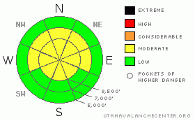
Danger Rose Tutorial
|
Continue to be suspicious of this terrain:
Continue to be suspicious of steep slopes where weak, faceted snow near the ground continues to linger such as on the slopes that face the north or east quadrants of the compass. Pay close attention to steepness and consequences.
Usually-safe terrain:
All slopes of 30 degrees of less not locally connected to steeper terrain.
Generally, the avalanche danger is Moderate. |
|
|
CURRENT CONDITIONS |

|
Yesterday's snow storm was much stronger than anticipated for Salt Lake and southward. Around a foot of new snow fell in the Cottonwood Canyons (with an inch of water weight). 15 inches fell at Brighton and Deer Valley . But life isn't fair, as we all know; Ogden and Logan got almost no snow. It felt strange to have a real snowstorm with light, fluffy snow without wind, which we haven't seen since....well...maybe last year.
This morning, temperatures are in the low 20's with continued light winds. |
|
|
RECENT ACTIVITY |

|
In the Salt Lake and Provo area mountains, there was a widespread avalanche cycle within the new snow yesterday morning from 6 am to 8 am when the precipitation intensity really spiked. During the day, backcountry travelers could trigger a few soft, sensitive, new snow avalanches especially where there was a solid crust underneath such as on the south facing slopes. Counter intuitively, the snow stayed in place better on the northerly facing slopes despite the presence of some pockets of surface hoar and some near surface faceted snow. One ski area reported a pocket in unskied terrain that likely broke into the deep layers of faceted snow near the ground but almost all the avalanches remained within the new snow.
Check out some good obs from Current Conditions such as Twin Lakes Pass, Emma Ridges, and No-No Name Bowl.
It goes without saying, but no avalanche activity was reported from the Ogden or Logan area mountains. |
|
|
THREAT #1 |

|
| WHERE |
PROBABILITY |
SIZE |
TREND |

|
|
|
|
| |
|
|
Over the next
24 hours.
|
|
|
Although you are much more likely to trigger new snow avalanches today, the largest hazard is from the possibility of deep slab avalanches because they have much larger consequences. It's almost impossible to forecast these or know where they will break but here's one trick I think is handy in these conditions:
Combine two basic principles of avalanches 1) Thin snow means weak snow, and 2) snow does not like rapid change. So as far as deep slab avalanches, I am most suspicious of shallow snowpack areas because when you add a uniform blanket of an inch of additional water weight, it's the shallow areas that not only have the weakest snow, but they also receive a disproportionally high additional amount of weight on top of the buried weak layers. For instance, the Snowbird SNOTEL site, yesterday's snow increased the total snowpack water equivalent by a measly 5.6% while Timpanogos Divide and Sundance Mid Mountain was increased by 14% and a couple stations on the Manti Skyline increased by 17% and one by 25%.. Geeky, I know, but it's a handy way to evaluate deep slab potential.
What this means in the Salt Lake area mountains is that you should be suspicious of snowpacks that are less than about 3-4 feet deep such as slopes that slid during the last storm, or traditionally thin snowpack areas such as outside the Cottonwood Canyons. |
|
|
MOUNTAIN WEATHER |

|
It's not quite over yet. Another pulse of moisture will mostly dive into southern Utah today and tonight but there will be enough to give us light snowfall in northern Utah. Skies should be cloudy with a chance of a few more flakes today. Tonight and Tuesday, we should get about 3 more inches of snow. Ridge top temperatures will be in the lower 20's today with light winds from the south.
Low level moisture should linger into Wednesday but the extended forecast is for clear weather for the next week or so. |
|
|
GENERAL ANNOUNCEMENTS |
If you trigger an avalanche in the backcountry - especially if you are adjacent to a ski area – please call the following teams to alert them to the slide and whether anyone is missing or not. Rescue teams can be exposed to significant hazard when responding to avalanches, and do not want to do so when unneeded. Thanks.
Salt Lake – Alta Central (801-742-2033)
Ogden – Snowbasin Patrol Dispatch (801-620-1017)
Provo – Sundance Patrol Dispatch (801-223-4150)
Dawn Patrol Forecast Hotline, updated by 05:30: 888-999-4019 option 8.
Twitter Updates for your mobile phone http://utahavalanchecenter.org/twitter)
Daily observations are frequently posted by 10 pm each evening.
Subscribe to the daily avalanche advisory e-mail click HERE.
UDOT canyon closures UDOT at (801) 975-4838
Wasatch Powderbird Guides does daily updates about where they'll be operating on this blog http://powderbird.blogspot.com/ .
You have the opportunity to participate in the creation of our own community avalanche advisory by submitting avalanche and snow observations. You can also call us at 801-524-5304 or 800-662-4140, or email by clicking HERE
Donate to your favorite non-profit –The Friends of the Utah Avalanche Center. The UAC depends on contributions from users like you to support our work.
We will update this forecast tomorrow morning. Thanks for calling. |
|
|
This information does not apply to developed ski areas or highways where avalanche control is normally done. This advisory is from the U.S.D.A. Forest Service, which is solely responsible for its content. This advisory describes general avalanche conditions and local variations always occur. |
|
This advisory provided by the USDA Forest Service, in partnership with:
The Friends of the Utah Avalanche Center, Utah Division of State Parks and Recreation, Utah Division of Emergency Management, Salt Lake County, Salt Lake Unified Fire Authority and the friends of the La Sal Avalanche Center. See our Sponsors Page for a complete list. |
