SPECIAL ANNOUNCEMENT |
 |
The Utah Avalanche Center is holding a fund raising auction of donated gear to support forecasting and education. We have Black Diamond and Surface Skis, several OR jackets, a BCA airbag pack, and some Scarpa AT boots. Go to ebay and search for "Utah Avalanche Center” or click HERE.
We also still have discount lift tickets for Alta, Snowbird, Brian Head, Sundance, and Wolf Mountain. All proceeds go towards avalanche forecasting and education. |
|
|
BOTTOM LINE
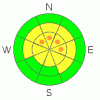
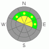
Danger by aspect and elevation on slopes approaching 35° or steeper.
(click HERE for tomorrow's danger rating)
|

Danger Rose Tutorial
|
The avalanche danger remains Moderate with pockets of Considerable Danger for a person or smaller avalanche triggering a deep slab avalanche breaking near the ground on northwest through north through easterly facing slopes at the upper elevations. Conservative decision making and avoiding steep, upper elevation terrain is the best way to avoid being caught in a dangerous slide.
If the snow adds up, the avalanche danger may rise to MODERATE for triggering a shallower slide in the new snow or that releases on the faceted weak layer in the upper snow pack. especially on wind drifted slopes. |
|
|
CURRENT CONDITIONS |

|
A small, but very welcome, storm is just getting going in the northern Utah mountains, with 1 to 3” of new snow as of 6 am. The southerly winds are very light at the moment, averaging less than 15 mph. Temperatures have cooled into the 20s, and the rain/snowline has dropped below 6,000’. |
|
|
RECENT ACTIVITY |

|
One avalanche was reported yesterday on west facing Y-Mountain in the Provo area mountains – probably a wet, loose natural triggered by afternoon sun and heating. |
|
|
THREAT #1 |

|
| WHERE |
PROBABILITY |
SIZE |
TREND |
|
|
|
|
| |
|
|
Over the next
24 hours.
|
|
|
Do not let the excitement of new snow or a shallow surface avalanche let you take your eyes off the real issue - the weak snow layers near the ground remains the most dangerous avalanche problem. The odds of triggering one of these deep avalanches has slightly increased with today’s snow - especially in the thinner snowpack areas, on a slope that is wind drifted or possibly triggered by the weight of a smaller avalanche. Any avalanche failing near the ground could be so deep it is unsurvivable. |
|
|
THREAT #2 |
|
|
|
MOUNTAIN WEATHER |

|
Light to moderate snowfall should continue for most of the day, with the heaviest snowfall rates expected late morning through this afternoon. 3 to 6 inches of snow are possible today south of I-80, with slightly less to the north. The Provo area mountains may be the favored location today. Temperatures will remain in the mid to upper 20s today, and the southwesterly winds will pick up into the 10 to 15 mph range, with the highest ridges averaging up to 20 mph. Lingering snow showers tonight could add another few inches to the snow totals. Temperatures will drop into the low teens tonight. Winds will shift to the northwest tonight, and are forecast to remain light, in the 10 to 20 mph range. After a brief break Sunday night and Monday, another storm will bring statewide snow to the mountains around Tuesday. |
|
|
GENERAL ANNOUNCEMENTS |
If you trigger an avalanche in the backcountry - especially if you are adjacent to a ski area – please call the following teams to alert them to the slide and whether anyone is missing or not. Rescue teams can be exposed to significant hazard when responding to avalanches, and do not want to do so when unneeded. Thanks.
Salt Lake – Alta Central (801-742-2033)
Ogden – Snowbasin Patrol Dispatch (801-620-1017)
Provo – Sundance Patrol Dispatch (801-223-4150)
Dawn Patrol Forecast Hotline, updated by 05:30: 888-999-4019 option 8.
Twitter Updates for your mobile phone http://utahavalanchecenter.org/twitter)
Daily observations are frequently posted by 10 pm each evening.
Subscribe to the daily avalanche advisory e-mail click HERE.
UDOT canyon closures UDOT at (801) 975-4838
Wasatch Powderbird Guides does daily updates about where they'll be operating on this blog http://powderbird.blogspot.com/ .
You have the opportunity to participate in the creation of our own community avalanche advisory by submitting avalanche and snow observations. You can also call us at 801-524-5304 or 800-662-4140, or email by clicking HERE
Donate to your favorite non-profit –The Friends of the Utah Avalanche Center. The UAC depends on contributions from users like you to support our work.
We will update this forecast tomorrow morning. Thanks for calling. |
|
|
This information does not apply to developed ski areas or highways where avalanche control is normally done. This advisory is from the U.S.D.A. Forest Service, which is solely responsible for its content. This advisory describes general avalanche conditions and local variations always occur. |
|
This advisory provided by the USDA Forest Service, in partnership with:
The Friends of the Utah Avalanche Center, Utah Division of State Parks and Recreation, Utah Division of Emergency Management, Salt Lake County, Salt Lake Unified Fire Authority and the friends of the La Sal Avalanche Center. See our Sponsors Page for a complete list. |

 Any place the new snow stacks up today, the most noticeable avalanche activity may occur near the surface - shallow slides failing on the recently buried small sugary facets and/or surface hoar layer. This scenario is a little bit sneaky and trickier than the average new snow avalanche problem - this weak layer is pockety, with some slopes more sensitive than others, and slides could break out above you or remotely from a distance. This weak layer is most widespread on shady upper and mid elevation slopes, and will be most sensitive on wind drifted slopes. Above is a great back lit photo from last year of what a buried surface hoar layer looks like.