Ogden Avalanche Advisory

Forecaster: Drew Hardesty

SPECIAL ANNOUNCEMENT

Hit our World Class Mountain Resorts and Support the Utah Avalanche Center. Discount lift tickets donated by Ski Utah and the Utah resorts and all the money goes to the UAC to keep the forecasts and education going. Details and purchase info here.

There are still openings in the Logan area Women’s Backcountry 101, this Thursday night and all day Saturday. For more information, go to the Education page HERE.

We are hosting an evening avy workshop for those wanting to fire the big lines & stay alive. Free talk by Forecaster Brett Kobernik, Alta Ski Patrol/SnowSafety/Wasatch Backcountry Rescue Dave Richards, and extreme skier/author Andrew McLean Thurs 2/9, 7pm @ Black Diamond Store. Optional Field day Mon 2/13 @ Snowbird Ski and Summer Resort. Thx to Surface Skis.


BOTTOM LINE

Danger by aspect and elevation on slopes approaching 35° or steeper.
(click HERE for tomorrow's danger rating)


Danger Rose Tutorial

Pockets of CONSIDERABLE avalanche danger exist for human triggered deep slab avalanches on the steep west to north to easterly facing terrain at the mid and upper elevations. While the likelihood of triggering these avalanches is diminishing, any slide breaking near the ground could be unsurvivable. Remember that these slides may still be triggered remotely from below.

Lower angle slopes, not locally connected to steeper terrain, remain the safest choice for travel.


CURRENT CONDITIONS

Overcast skies signal the approach of a sharply splitting storm with the southern branch diving down over Baja. The northern branch moves through southern Idaho/northern Utah today. Temps are in the mid to upper 20s; winds are westerly and generally less than 20mph. Riding conditions remain pretty good on the low angle recycled powder, though one has to be creative to find untracked moderate slopes. It can be done.


RECENT ACTIVITY

No reports of activity from the backcountry. We always appreciate any/all observations from the backcountry – collapsing, long running sluffs, even that you went on what they used to call a Super Tour and had NO signs of instability. It doesn’t have to be a large avalanche – everything is important. Also, don’t assume we’ll hear about it from someone else - we rely on you to help paint a complete picture of the backcountry. Thanks.


THREAT #1

WHERE PROBABILITY SIZE TREND
      Over the next 24 hours.

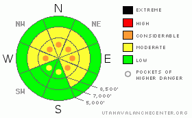
Danger ratings are a combination of

· Likelihood/probability (to include sensitivity/geographical distribution)

· Consequence/size/type of avalanche

· Other Intangibles - Confidence level, Predictability/Manageability; Pucker Factor

And it’s all a matter of scale on the Risk Ladder of Low-Moderate-Considerable-High-Extreme

In our current situation, the likelihood of triggering one of these deep slabs is diminishing, though the geographical distribution (based upon snow structure of slab over depth hoar) comprises more than half the terrain (west through north through southeasterly facing terrain.) – not coincidentally the terrain that has the best snow conditions. It’s good news/bad news here.

Consequences are mostly bad news. These deep slabs are between 2’-5’ deep, 100’-1000’ wide. Worse if a catch and carry drags you through the trees, over a cliff band and into a deep walled gulley or abrupt transition.

Confidence level is low – one could possibly ride 5 lines but trigger the deep slab on the 6th. Stability tests show conflicting results. Avalanches may pull out way above you. Many have naturalled during the January cycle but have since re-loaded. Still more bad news.

The things you have absolute control over are Terrain and Companions. Stack the odds by choosing good, reliable, safe companions with similar levels of acceptable risk. Choose terrain where you don’t have to play the odds – slopes less than 30 degrees with nothing steeper above. Simple.


THREAT #2

WHERE PROBABILITY SIZE TREND
      Over the next 24 hours.

There are also a handful of other minor avalanche concerns to keep on your radar -

· It is now easy to trigger small sluffs in the weak surface snow on steep, shady slopes. This sluffing indicates to me that we now have another well established weak layer, and I’m about ready to place my bet that that the current surface snow will be the most active weak layer with our next storm cycle.

· Cornices, as always, pose a threat to the unwary ridge-walker. Any large cornice (plus unwary ridge-walker) may be enough of a trigger to release one of our deeper slabs. We’ve had a number of fatalities over the years from unfortunate events as these (the most recent a snowmobiler two years ago).

Stronger ridgetop westerly winds yesterday may have created a few scattered new wind drifts in the high terrain along the Ogden skyline. Avoid any new or obvious wind deposited snow.


MOUNTAIN WEATHER

A weak weather system today and tonight may produce 1-3”, though this may be my optimism showing through. Ridgetop winds will be westerly at 10-15mph while temps remain in the mid to low 20s. Winds may be gusty at times as the wave moves through. The new fluff may serve only to insulate the surface hoar and faceted snow...for problems down the road. High pressure builds back in for the remainder of the week, with a couple more apparently splitting storms on tap for the weekend and early next week.


GENERAL ANNOUNCEMENTS

If you trigger an avalanche in the backcountry - especially if you are adjacent to a ski area – please call the following teams to alert them to the slide and whether anyone is missing or not. Rescue teams can be exposed to significant hazard when responding to avalanches, and do not want to do so when unneeded. Thanks.

Salt Lake – Alta Central (801-742-2033)

Ogden – Snowbasin Patrol Dispatch (801-620-1017)

Provo – Sundance Patrol Dispatch (801-223-4150)

Dawn Patrol Forecast Hotline, updated by 05:30: 888-999-4019 option 8.

Twitter Updates for your mobile phone http://utahavalanchecenter.org/twitter)

Daily observations are frequently posted by 10 pm each evening.

Subscribe to the daily avalanche advisory e-mail click HERE.

UDOT canyon closures UDOT at (801) 975-4838

Wasatch Powderbird Guides does daily updates about where they'll be operating on this blog http://powderbird.blogspot.com/ .

You have the opportunity to participate in the creation of our own community avalanche advisory by submitting avalanche and snow observations. You can also call us at 801-524-5304 or 800-662-4140, or email by clicking HERE

Donate to your favorite non-profit –The Friends of the Utah Avalanche Center. The UAC depends on contributions from users like you to support our work.

We will update this forecast tomorrow morning. Thanks for calling.


This information does not apply to developed ski areas or highways where avalanche control is normally done.  This advisory is from the U.S.D.A. Forest Service, which is solely responsible for its content. This advisory describes general avalanche conditions and local variations always occur.


This advisory provided by the USDA Forest Service, in partnership with:

The Friends of the Utah Avalanche Center, Utah Division of State Parks and Recreation, Utah Division of Emergency Management, Salt Lake County, Salt Lake Unified Fire Authority and the friends of the La Sal Avalanche Center. See our Sponsors Page for a complete list.