SPECIAL ANNOUNCEMENT |
 |
Stay connected with the UAC through Facebook and Twitter. Keep apprised of events as they happen - we often send out updates from the field.
Free Avalanche Awareness Seminars
Mon., Jan. 30th and Mon., Feb. 13th
6:30 PM
Slackwater Pub and Pizzeria
1895 Washington Blvd.
Ogden, UT
Info: 801-399-0637 |
|
|
BOTTOM LINE
Danger by aspect and elevation on slopes approaching 35° or steeper.
(click HERE for tomorrow's danger rating)
|
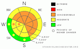
Danger Rose Tutorial
|
This is the Bottom Line Yesterday and It’s the Bottom Line for Today –
Very dangerous conditions exist in the backcountry.
There is a CONSIDERABLE avalanche danger for triggering deep slab avalanches and a MODERATE danger for triggering any recent wind drifts. It’s not HIGH danger anymore, but the travel recommendations remain the same. I’d avoid the steep westerly to north to southeast facing slopes at the mid and upper elevations.
There is great powder for turning and riding on shady, mid and upper elevation low angle slopes. Or enjoy the turns at one of our world class mountain resorts. |
|
|
CURRENT CONDITIONS |

|
By now, most of you are probably aware of the avalanche fatality on Kessler Peak in Big Cottonwood Canyon yesterday. A 25 year old snowboarder triggered and was killed by a 3’ deep and reported 1000’ wide hard slab avalanche that carried him over 2400’. It was on a steep west to northwest facing slope at 10,200’. Our Preliminary Accident Report can be found here. Our condolences go to his family and friends.
Under blue-bird clear skies, mountain temps are 10-15 degrees warmer than this time yesterday. 10,000’ temps are in the mid 20s; westerly winds are less than 15mph. Soft settled powder exists in the northerly terrain; the southerly aspects hold soon-to-soften sun crusts. |
|
|
RECENT ACTIVITY |

|
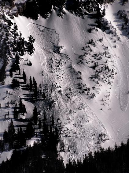
Very large deep slab avalanches continue to be triggered with explosives at the ski resorts in the Ogden area mountains...In the central Wasatch -
Backcountry riders triggered two other hard slab avalanches in the backcountry – one from safe terrain, one from avalanche terrain.
· Holy Toledo – a rider traversed in, made a couple of turns and had the hard slab avalanche break out well above and adjacent to his line. The slide, an estimated 2’ deep and 150’ wide ripped out on a northwest facing slope at 10,200’.
· Porter Fork – a touring party ascending a ridgeline remotely triggered a 3’ deep and 200’ wide hard slab on a steep northeast facing slope at 9400’. The avalanche debris nearly overran a pre-existing up-track.
Propagating spooky collapses were also reported in suspect northerly – and southeast facing terrain.
Photo of Holy Toledo avalanche below (pic Todd Glew)
|
|
|
THREAT #1 |

|
| WHERE |
PROBABILITY |
SIZE |
TREND |

|
|
|
|
| |
|
|
Over the next
24 hours.
|
|
|
Deep slabs are incredibly dangerous for a number of reasons. You can dig multiple snow pits that point toward stable snow. You can see multiple tracks on a slope. You may not hear collapsing or see shooting cracks. It doesn’t matter. The snowpack is a wolf in sheep’s clothing and will remain so for awhile. As time goes on, these slabs become more stubborn and harder to trigger, but still have the potential to be deadly. Whereas last weekend there were 6 bullets in the chamber for Russian roulette, now there are only three. Best to keep the safety locked.
High level backcountry experts are choosing terrain that A-has already avalanched with little likelihood of repeating, B-holds little to no weak faceted snow, or C-has a modest enough slope angle that it will not slide (nor is it connected to steeper terrain above). Or D-all of the above. It may not seem like it on a powder day, but the snowpack is not your friend right now. Your friend is – and will always be - terrain. Make wise choices today in the mountains. |
|
|
THREAT #2 |

|
| WHERE |
PROBABILITY |
SIZE |
TREND |

|
|
|
|
| |
|
|
Over the next
24 hours.
|
|
|
A few lingering wind drifts from the past few days stronger ridgetop westerlies may still be triggered in the steepest lee (often east-facing) terrain, particularly with rapid warming today. |
|
|
THREAT #3 |

|
| WHERE |
PROBABILITY |
SIZE |
TREND |
|
|
|
|
| |
|
|
Over the next
12 hours.
|
|
|
It’s almost February – and with rapidly warming temperatures and direct sun, the soon damp and softening southerly facing snow will be susceptible to initiation on the steepest slopes, particularly by midday into the afternoon. Don’t overstay your welcome consider your time frame on the exits. |
|
|
MOUNTAIN WEATHER |

|
Should be a nice day in the hills with clear skies, temps rising to the upper 20s at 10,000’ and the mid 30s at 8000’. We might start to see some patchy clouds rolling in ahead of a weak system due tomorrow afternoon. Winds will be 10-15mph from the west. The longer range weather models don’t look too promising. |
|
|
GENERAL ANNOUNCEMENTS |
Salt Lake – Alta Central (801-742-2033)
Ogden – Snowbasin Patrol Dispatch (801-620-1017)
Provo – Sundance Patrol Dispatch (801-223-4150)
Dawn Patrol Forecast Hotline, updated by 05:30: 888-999-4019 option 8.
Daily observations are frequently posted by 10 pm each evening.
Subscribe to the daily avalanche advisory e-mail click HERE.
UDOT canyon closures UDOT at (801) 975-4838
Wasatch Powderbird Guides does daily updates about where they'll be operating on this blog http://powderbird.blogspot.com/ .
You have the opportunity to participate in the creation of our own community avalanche advisory by submitting avalanche and snow observations. You can also call us at 801-524-5304 or 800-662-4140, or email by clicking HERE
Donate to your favorite non-profit –The Friends of the Utah Avalanche Center. The UAC depends on contributions from users like you to support our work.
We will update this forecast tomorrow morning. Thanks for calling. |
|
|
This information does not apply to developed ski areas or highways where avalanche control is normally done. This advisory is from the U.S.D.A. Forest Service, which is solely responsible for its content. This advisory describes general avalanche conditions and local variations always occur. |
|
This advisory provided by the USDA Forest Service, in partnership with:
The Friends of the Utah Avalanche Center, Utah Division of State Parks and Recreation, Utah Division of Emergency Management, Salt Lake County, Salt Lake Unified Fire Authority and the friends of the La Sal Avalanche Center. See our Sponsors Page for a complete list. |
