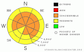
BOTTOM LINE
Danger by aspect and elevation on slopes approaching 35° or steeper.
(click HERE for tomorrow's danger rating)
|
Danger Rose Tutorial
|
The Avalanche Warning for the Ogden, Park City, Salt Lake and Provo area mountains has been dropped, but a CONSIDERABLE avalanche danger does remain on steep, mid and upper elevation slopes facing west through north through southeast in the Ogden area mountains. It is still possible for people to trigger large avalanches breaking 2 to 5 feet deep, and to trigger slides remotely from a distance and from the bottom of steep slopes. Also avoid any steep slope with new deposits of wind drifted snow.
Slope angle, slope angle, slope angle – there is great riding, snow shoeing and touring to be had – but keep to slopes less steep than about 30 degrees with no steep slopes above. An inclinometer to honestly measure slope angles is essential. |
|
|
CURRENT CONDITIONS |

|
A mild westerly flow has brought partly cloudy skies and warming temperatures to the mountains this morning. Most stations are averaging near 20 degrees, with a few teens remaining at the highest elevations. The winds are from the west northwest, averaging 15 mph, with gusts to 30, and the across the high peaks are in the 25 to 30 mph range, with gusts to 35 mph.
Riding, turning and snowshoeing on low angle slopes are excellent, in powder on a mostly supportable base. Some of the sunny slopes did get crusted yesterday. |
|
|
RECENT ACTIVITY |

|
 With clear skies, yesterday’s sightseeing gave you an eyeful, whether looking around at the resorts or in the backcountry. It’s as educational as it gets, with numerous avalanches to be seen, at a variety of sizes, elevations and aspects. Some detective work is necessary, though, as many avalanches are rapidly filling in – look for clues in both the crowns and debris piles. With clear skies, yesterday’s sightseeing gave you an eyeful, whether looking around at the resorts or in the backcountry. It’s as educational as it gets, with numerous avalanches to be seen, at a variety of sizes, elevations and aspects. Some detective work is necessary, though, as many avalanches are rapidly filling in – look for clues in both the crowns and debris piles.
One backcountry slide was remotely triggered yesterday in the Bear Trap gully (above), a 75’ wide soft slab failing on facets, representative of the mid elevation issues. Ski area explosive control work in Big and Little Cottonwood continued to release medium to large avalanches, many breaking deep and wide. |
|
|
THREAT #1 |

|
| WHERE |
PROBABILITY |
SIZE |
TREND |
|
|
|
|
| |
|
|
Over the next
24 hours.
|
|
|
If it is steep, white and smooth – no way. It is still likely that any slope that has not recently slid can be triggered by a person, and the avalanche will be deep, big and deadly. The evidence is the widespread avalanche cycle, with slides failing on one of the numerous layers of weak facets. Many of the upper elevation slides are wide, but the deep, pockety mid elevation slides at breakovers and near cliffs are still dangerous, especially where the snow can pile up in a gully or other terrain trap. Avalanches can be triggered remotely from a distance, and from below.
Unfortunately, as we visit slide paths, we’re finding that advanced facets remained in bed surfaces.
So we are getting set up for repeaters – a second avalanche cycle on the same slope – as soon as the paths fill in with more snow, which may start today in the form of wind blown snow. |
|
|
THREAT #2 |

|
| WHERE |
PROBABILITY |
SIZE |
TREND |

|
|
|
|
| |
|
|
Over the next
24 hours.
|
|
|
The moderate to strong northwesterly winds at the higher elevations will be drifting the new, light powder into sensitive wind drifts of along the higher ridgelines. The sensitive drifts will be most widespread on slopes facing northeast through southeast, but watch for smooth, rounded drifts off the ridges, around sub ridges, rocks, and slope breakovers – any where the wind slows and deposits it’s snow. |
|
|
MOUNTAIN WEATHER |

|
Skies will be mostly cloudy today, with blustery northwesterly winds along the higher ridges. 30 to 40 mph averages, with gusts to 50 are expected. Once off the ridgelines, average speeds should remain below 15 mph. Temperatures will warm, into the upper 30’s at 8,000’ and near 30 at 10,000’. A few snow flurries are possible.
The next snow producer will be a cold front crossing the area Thursday night, with the heaviest snowfall occurring north of I-80, due to a longer period of prefrontal precipitation on a southwesterly flow. A foot of snow possible to the north of I-80, with 6 to 10 inches likely to the south. |
|
|
GENERAL ANNOUNCEMENTS |
Salt Lake – Alta Central (801-742-2033)
Ogden – Snowbasin Patrol Dispatch (801-620-1017)
Provo – Sundance Patrol Dispatch (801-223-4150)
Dawn Patrol Forecast Hotline, updated by 05:30: 888-999-4019 option 8.
Daily observations are frequently posted by 10 pm each evening.
Subscribe to the daily avalanche advisory e-mail click HERE.
UDOT canyon closures UDOTat (801) 975-4838
Wasatch Powderbird Guides does daily updates about where they'll be operating on this blog http://powderbird.blogspot.com/ .
You have the opportunity to participate in the creation of our own community avalanche advisory by submitting avalanche and snow observations. You can also call us at 801-524-5304 or 800-662-4140, or email by clicking HERE
Donate to your favorite non-profit –The Friends of the Utah Avalanche Center. The UAC depends on contributions from users like you to support our work.
We will update this forecast tomorrow morning. Thanks for calling. |
|
|
This information does not apply to developed ski areas or highways where avalanche control is normally done. This advisory is from the U.S.D.A. Forest Service, which is solely responsible for its content. This advisory describes general avalanche conditions and local variations always occur. |
|
This advisory provided by the USDA Forest Service, in partnership with:
The Friends of the Utah Avalanche Center, Utah Division of State Parks and Recreation, Utah Division of Emergency Management, Salt Lake County, Salt Lake Unified Fire Authority and the friends of the La Sal Avalanche Center. See our Sponsors Page for a complete list. |
