SPECIAL ANNOUNCEMENT |
 |
Drew will be giving a FREE avalanche Awareness talk at 7 pm tonight at the Sprague Library at 2131 south 1100 east SLC. While sponsored by the WMC, the talk is open to the public.
There are a number of slots open for our Advanced Avalanche Workshop later this month. Brett Kobernik will lead this class which will focus on our remarkable weak layer formation this year and persistent weakness in general. DETAILS
There are also a few slots open in Evelyn's womens Backcountry 101. DETAILS |
|
|
BOTTOM LINE
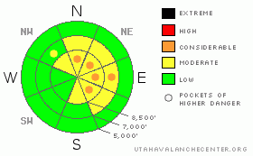
Danger by aspect and elevation on slopes approaching 35° or steeper.
(click HERE for tomorrow's danger rating)
|
Danger Rose Tutorial
|
There are Pockets of CONSIDERABLE avalanche danger today - most wide spread where new drifts of wind blown snow overlay weak facets, though slides can also be triggered in the older, more subtle wind drifts. The new drifts are most widespread on upper elevation slopes facing north through southeast. Getting caught and carried in any slide breaking on the buried facets will have severe consequences, due to the likelihood of hitting rocks.
The overall MODERATE danger on many steep slopes means human triggered avalanches are possible, and you need the ability to evaluate snow and terrain carefully, and be able to identify features of concern. |
|
|
CURRENT CONDITIONS |

|
A cold northerly flow is in place and under cloudy skies a stray snowflake or two has been spotted. Temperatures have been dropping, and are now in the single digits and teens. The northwesterly winds increased overnight, most noticeably at the 11,000’ level, with average speeds in the 40 mph range, with gusts occasionally into the 60s. Out of the wind zone, average speeds are closer to 15 mph, with gusts to 25. Good turns or riding conditions are few and far between. |
|
|
RECENT ACTIVITY |

|
Yesterday, the only avalanches reported were two explosive triggered slides in uncompacted terrain of a ski area. Backcountry reports detailed “more of the same” – loose snow sluffs gouging and running decently far in continuously steep terrain, and cracking and collapsing in the Salt Lake and Ogden mountains. |
|
|
THREAT #1 |

|
| WHERE |
PROBABILITY |
SIZE |
TREND |
|
|
|
|
| |
|
|
Over the next
24 hours.
|
|
|
While the faceted snow is widespread, in most places it’s missing any slab above to be the avalanche. Today, it’s the intersection of the new wind drifts over faceted snow that have the highest danger, mostly confined to the higher ridgelines. However, don’t be complacent - there are still isolated places where slides could be triggered on the older wind drifts, too. Slides failing on facets have the unenviable characteristics of being able to be triggered remotely from a distance or having trigger points off the ridgelines, allowing avalanches to release mid slope or break out above you. Collapsing is a sure sign of a dangerous slab/weak layer combo. |
|
|
THREAT #2 |

|
| WHERE |
PROBABILITY |
SIZE |
TREND |
|
|
|
|
| |
|
|
Over the next
24 hours.
|
|
|
Today’ steady northwesterly winds will be some drifting snow, mostly along the upper elevation ridgelines. While you always want to avoid wind drifts on any steep slopes, today’s drifts are especially dangerous and easier to trigger where they sit above the weak faceted snow. Cracking of the snow and a smooth, rounded pillowy look will help identify these drifts. Wind drifts are sneaky – you’ll find them in the obvious places along ridgelines but also cross loaded around sub ridges and mid slope breakovers. |
|
|
MOUNTAIN WEATHER |

|
It will feel noticeably more wintry today, with cloudy skies, a few snow flurries, and 10,000’ temperatures near 10 degrees. The northwesterly winds will make it feel even colder – speeds will remain elevated through the morning – averaging near 15 mph, with gusts to 30, in most terrain, with the highest ridgelines averaging to 40 mph with gusts in the 50s. Wind speeds will gradually taper off today and tonight as the flow shifts to the north. Then high pressure will regain control, with warming temperatures through the weekend, though there is a hint of some sort of change early next week. |
|
|
GENERAL ANNOUNCEMENTS |
If you trigger an avalanche in the backcountry - especially if you are adjacent to a ski area – please call the following teams to alert them to the slide and whether anyone is missing or not. Rescue teams can be exposed to significant hazard when responding to avalanches, and do not want to do so when unneeded. Thanks.
Salt Lake – Alta Central (801-742-2033)
Ogden – Snowbasin Patrol Dispatch (801-620-1017)
Provo – Sundance Patrol Dispatch (801-223-4150)
Dawn Patrol Forecast Hotline, updated by 05:30: 888-999-4019 option 8.
Daily observations are frequentlypostedby 10 pm each evening.
Subscribe to the daily avalanche advisory e-mail clickHERE.
UDOT canyon closuresUDOTat (801) 975-4838
Wasatch Powderbird Guides are suspending the opening of helicopter skiing operations. Once we have enough snow cover, daily updates to this bloghttp://powderbird.blogspot.com/will begin for the 2011-2012 season.
You have the opportunity to participate in the creation of our own community avalanche advisory by submittingavalanche and snow observations. You can also call us at 801-524-5304 or 800-662-4140, or email by clickingHERE
Donate to your favorite non-profit –The Friends of the Utah Avalanche Center. The UAC depends on contributions from users like you to support our work.
We will update this forecast tomorrow morning. Thanks for calling.. |
|
|
This information does not apply to developed ski areas or highways where avalanche control is normally done. This advisory is from the U.S.D.A. Forest Service, which is solely responsible for its content. This advisory describes general avalanche conditions and local variations always occur. |
|
This advisory provided by the USDA Forest Service, in partnership with:
The Friends of the Utah Avalanche Center, Utah Division of State Parks and Recreation, Utah Division of Emergency Management, Salt Lake County, Salt Lake Unified Fire Authority and the friends of the La Sal Avalanche Center. See our Sponsors Page for a complete list. |
