SPECIAL ANNOUNCEMENT |
 |
The special avalanche advisory for the mountains of northern and central Utah has been extended through Sunday. Dangerous avalanche conditions exist. Large avalanches can easily be triggered by people on steep wind drifted slopes and from a distance. Backcountry travel in steep avalanche terrain is not recommended. |
|
|
BOTTOM LINE
Danger by aspect and elevation on slopes approaching 35° or steeper.
(click HERE for tomorrow's danger rating)
|
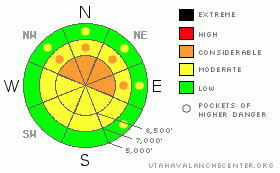
Danger Rose Tutorial
|
Dangerous avalanche conditions exist – the avalanche danger is CONSIDERABLE on steep wind drifted mid and upper elevation slopes facing northwest through east or any slope with snow pooled beneath cliffs and gullies. Avalanches one to two feet deep and over 150 feet wide can be triggered. Backcountry travel on, below and adjacent to steep avalanche terrain is not recommended.
GO TO Terrain: Play on low angle terrain, about 30 degrees or less in steepness, like gentle meadows, that are well away from steep slopes. |
|
|
CURRENT CONDITIONS |

|
Unwanted high pressure has returned, bringing clear skies and the now familiar pattern of cool air trapped in the canyon bottoms, while temperatures at the mid and upper elevations have already warmed into the low to mid 20s. Winds are from the west, generally averaging less than 15 mph, with only the highest peaks occasionally having gusts into the 30s. The wind drifts, facets, supportable and breakable ice crusts have received no compliments. |
|
|
RECENT ACTIVITY |

|
A few very experienced travelers hit the backcountry yesterday. Drew observed the steep, northerly facing terrain in upper Maybird Gulch from the Pfeifferhorn east had a natural cycle, avalanching wall to wall. Along the Park City ridge line, two slides were easily triggered on northeast facing West Monitor. A small cornice drop triggered a hard slab 175' wide by 2'deep; a snowball a smaller soft slab releasing mid slope. At Brighton, a snowboarder remotely triggered a small hard slab in unopened terrain. There were also reports of widespread cracking and collapsing below 10,000’. Details and great photos are on our Current Conditions page. |
|
|
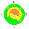
THREAT #1 |

|
| WHERE |
PROBABILITY |
SIZE |
TREND |
|
|
|
|
| |
|
|
Over the next
24 hours.
|
|
|
The wind was a game changer – dense soft and hard slabs are now scattered across the landscape, just waiting to be triggered. These slides will be one to two feet deep, over 100 feet wide, failing on the weak facets beneath and large enough to catch, carry and bury a person.
With a facet/hard slab combo, slides can be triggered from a distance, break out above you, or release mid slope. Snow also pooled beneath cliffs and at the base of gullies, and slides could break out on these heavily loaded, lower angle slopes.
Conditions change over short distances. Watch what you are connected to - do not cross below steep terrain and avoid terrain adjacent to steep slopes. Recent avalanches, cracking or collapsing (a whoomphing noise) are red flags – the snow pack is unstable - stay off and out from under steep slopes. |
|
|
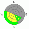
THREAT #2 |

|
| WHERE |
PROBABILITY |
SIZE |
TREND |
|
|
|
|
| |
|
|
Over the next
10 hours.
|
|
|
Snow never likes rapid change, and the direct sun and rapidly warming temperatures could make the snow sensitive on steep slopes facing southeast through west. Watch for changing conditions with heating today. |
|
|
MOUNTAIN WEATHER |

|
Another strong ridge of high pressure already has a choking grip on our weather – westerly winds will average less than 15 mph today, gusting to 35 only across the highest ridges. Temperatures are marching upward, and will reach near 40 at 8,000’ and near 30 at 10,000’. The mostly clear skies and warm temperatures will haunt us through the week, with only slight variations. |
|
|
GENERAL ANNOUNCEMENTS |
If you trigger an avalanche in the backcountry - especially if you are adjacent to a ski area – please call the following teams to alert them to the slide and whether anyone is missing or not. Rescue teams can be exposed to significant hazard when responding to avalanches, and do not want to do so when unneeded. Thanks.
Salt Lake – Alta Central (801-742-2033)
Ogden – Snowbasin Patrol Dispatch (801-620-1017)
Provo – Sundance Patrol Dispatch (801-223-4150)
Dawn Patrol Forecast Hotline, updated by 05:30: 888-999-4019 option 8.
Daily observations are frequently posted by 10 pm each evening.
Subscribe to the daily avalanche advisory e-mail click HERE.
UDOT canyon closures UDOT at (801) 975-4838
Wasatch Powderbird Guides are suspending the opening of helicopter skiing operations. Once we have enough snow cover, daily updates to this blog http://powderbird.blogspot.com/will begin for the 2011-2012 season.
You have the opportunity to participate in the creation of our own community avalanche advisory by submitting avalanche and snow observations. You can also call us at 801-524-5304 or 800-662-4140, or email by clicking HERE
Donate to your favorite non-profit –The Friends of the Utah Avalanche Center. The UAC depends on contributions from users like you to support our work.
We will update this forecast tomorrow morning. Thanks for calling.. |
|
|
This information does not apply to developed ski areas or highways where avalanche control is normally done. This advisory is from the U.S.D.A. Forest Service, which is solely responsible for its content. This advisory describes general avalanche conditions and local variations always occur. |
|
This advisory provided by the USDA Forest Service, in partnership with:
The Friends of the Utah Avalanche Center, Utah Division of State Parks and Recreation, Utah Division of Emergency Management, Salt Lake County, Salt Lake Unified Fire Authority and the friends of the La Sal Avalanche Center. See our Sponsors Page for a complete list. |
