Ogden Avalanche Advisory

Forecaster: Evelyn Lees

BOTTOM LINE

Danger by aspect and elevation on slopes approaching 35° or steeper.
(click HERE for tomorrow's danger rating)


Danger Rose Tutorial

The avalanche danger is MODERATE on steep mid and upper elevation slopes, facing northwest through east, for triggering a soft slab, old wind drift or a loose snow sluff. With daytime heating, a few damp sluffs could be triggered on steep sunny slopes. Cracking and collapsing indicate weak layering, and are warning signs to stay off steep slopes. If you trigger a slide, it's probably big enough to catch and carry you, and any ride would be rough, rocky and injury producing.


THREAT #1

WHERE PROBABILITY SIZE TREND
      Over the next 24 hours.

Up high in the mountains, the skies are all clear,

It’s a beautiful morning, filled with holiday cheer.

The temperatures have warmed at 10,000 feet

Into the upper 20s and low 30s – we’re talking heat!

The northerly winds decreased and are quite light

Speeds have averaged less the 15 for much of the night

Snow conditions remain thin; it’s Rok-Pow at best

But it’s still decently fun – certainly better than much of the west.

At the shady mid and upper elevations, on a wind shelter slope

You can find a bit of soft powder, so don’t give up hope.

Yesterday, there was one report from the backcountry of spider web cracks,

An east facing slope shattered, but no movement downhill of the snowpack.

The facets keep growing as we sleep through the night,

Loose, sugary, sparkly and not bonded tight.

So there are still 2 avalanche concerns of which to beware,

Soft slabs and loose sluffs are possible - so backcountry travelers must take care.

Buried shallowly in the snowpack are surface hoar feathers and facet squares,

And shallow slabs could be triggered on these weak layers.

Perhaps old, cracky winds drifts, with a collapse here and there

So stay on your toes, on steep slopes they could give you a scare.

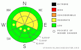
It’s a MODERATE DANGER on steep slopes facing northwest, north and northeast,

So at mid and upper elevations, approach these slopes with caution at the very least.

There’s also a MODERATE DANGER for triggering a long running sluff,

If you’re caught and carried it won’t be just fluff.

Any ride would be rough, through rocks and debris,

Maybe no burial, but probably an injury

Later today watch for heating and the hot sun,

Small damp sluffs will be possible and similarly, not much fun

Remember, MODERATE DANGER means you can trigger a slide,

And it’s always dangerous to be caught and take a ride.

Weather wise, today in the mountains will be a delight,

Skies will be clear and the northwest winds very light

Temperatures will soar to 30 and above,

At 10,000’ – why you’ll need just a light glove.

At 8,000 feet, 40 degrees could be the high,

It’s not very wintry – I really can’t lie.

But what does the future have in store?

By mid to late week, of snow, perhaps a few inches more.

Weak waves will ripple across northern Utah in a fast westerly flow,

Each with a chance for white flakes, though snow totals look to be low.

And so we at the UAC wish you a safe, happy holiday week,

And we too, are hoping for lots of powder to make the snow pack deep.


GENERAL ANNOUNCEMENTS

If you trigger an avalanche in the backcountry - especially if you are adjacent to a ski area – please call the following teams to alert them to the slide and whether anyone is missing or not. Rescue teams can be exposed to significant hazard when responding to avalanches, and do not want to do so when unneeded. Thanks.

Salt Lake – Alta Central (801-742-2033)

Ogden – Snowbasin Patrol Dispatch (801-620-1017)

Provo – Sundance Patrol Dispatch (801-223-4150)

Dawn Patrol Forecast Hotline, updated by 05:30: 888-999-4019 option 8.

Daily observations are frequently posted by 10 pm each evening.

Subscribe to the daily avalanche advisory e-mail clickHERE.

UDOT canyon closures UDOTat (801) 975-4838

You have the opportunity to participate in the creation of our own community avalanche advisory by submitting avalanche and snow observations. You can also call us at 801-524-5304 or 800-662-4140, or email by clickingHERE

Donate to your favorite non-profit –The Friends of the Utah Avalanche Center. The UAC depends on contributions from users like you to support our work.

We will update this forecast tomorrow morning. Thanks for calling.


This information does not apply to developed ski areas or highways where avalanche control is normally done.  This advisory is from the U.S.D.A. Forest Service, which is solely responsible for its content. This advisory describes general avalanche conditions and local variations always occur.


This advisory provided by the USDA Forest Service, in partnership with:

The Friends of the Utah Avalanche Center, Utah Division of State Parks and Recreation, Utah Division of Emergency Management, Salt Lake County, Salt Lake Unified Fire Authority and the friends of the La Sal Avalanche Center. See our Sponsors Page for a complete list.