SPECIAL ANNOUNCEMENT |
 |
Apologies for the late products - we're having web site difficulties. |
|
|
BOTTOM LINE
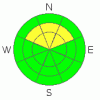
Danger by aspect and elevation on slopes approaching 35° or steeper.
(click HERE for tomorrow's danger rating)
|

Danger Rose Tutorial
|
The avalanche danger is MODERATE on steep mid and upper elevation slopes, facing northwest through east, for triggering a soft slab or sluff. The avalanche danger is also MODERATE on any steep slope with stiff drifts of wind blown snow – hollow sounding, denser snow, cracking and collapsing are all indicators of wind drifts.
|
|
|
CURRENT CONDITIONS |

|
Under clear skies, temperatures are about 10 degrees warmer than yesterday morning, close to 20 degrees at 10,000’. Colder air is trapped in the canyon bottoms, however, giving a few readings in the single digits. The northerly winds are generally less than 15 mph, though the highest peaks are still averaging 20 to 25, with gusts to 40 at times.
It’s “rock-pow” conditions, but at least it’s the “greatest rock-pow on earth”. In super wind sheltered terrain, it is possible to find turns in soft facets and powder, but increasingly hard to avoid sinking in, rocks, stumps or dense wind drifts.
|
|
|
RECENT ACTIVITY |

|
There was one reported skier released soft slab yesterday in Cardiac Bowl, on a northeasterly facing slope at 10,500’, about 10 inches deep by 25 feet wide, that failed on surface hoar and/or facets. In the backcountry near Brighton, a combo slab/sluff was reported from Mary's chute,. All in all, it was a fairly quite day, which could be due to lack of backcountry travelers (triggers).
|
|
|
THREAT #1 |

|
| WHERE |
PROBABILITY |
SIZE |
TREND |

|
|
|
|
| |
|
|
Over the next
24 hours.
|
|
|
The possibility of triggering any sort of shallow slab avalanche – either a wind drift or an old denser layer of snow - remains the number one concern. Any sort of slab would be big enough to catch and carry a person and the resulting ride could be rough – dragging you through rocks or trees. Cracks in the surface snow or the heart stopping sound of a collapse (or whoomph) are good indicators you’ve entered terrain where you could trigger a slide.
|
|
|
THREAT #2 |

|
| WHERE |
PROBABILITY |
SIZE |
TREND |
|
|
|
|
| |
|
|
Over the next
24 hours.
|
|
|
Large, loose snow sluffs continue to be easy to trigger on steep, shady slopes and can pick up surprising speed and volume. Again, the greatest concern is the ride you would take if caught by one. Also, there is a possibility of triggering a damp, loose snow sluff today or tomorrow, due to the combination of direct sun and increasingly warm temperatures. This would be on a steep, south or southwesterly facing slope later in the day.
|
|
|
MOUNTAIN WEATHER |

|
High pressure will continue to dominate the weather through the weekend, with steadily warming temperatures. 10,000’ highs today will reach the upper 20’s today, and into the low 30’s Sunday. The northerly winds will still add a chill edge today across the highest terrain - with highest peaks occasionally averaging in the 20 to 25 mph range, with gusts in the 40’s. Wind speeds will generally average less than 15 mph in the mid elevation terrain. Looking to the future, a series of very weak systems will graze the area starting mid week, each with a chance for a few inches of snow.
|
|
|
GENERAL ANNOUNCEMENTS |
If you trigger an avalanche in the backcountry - especially if you are adjacent to a ski area – please call the following teams to alert them to the slide and whether anyone is missing or not. Rescue teams can be exposed to significant hazard when responding to avalanches, and do not want to do so when unneeded. Thanks.
Salt Lake – Alta Central (801-742-2033)
Ogden – Snowbasin Patrol Dispatch (801-620-1017)
Provo – Sundance Patrol Dispatch (801-223-4150)
Dawn Patrol Forecast Hotline, updated by 05:30: 888-999-4019 option 8.
Daily observations are frequently posted by 10 pm each evening.
Subscribe to the daily avalanche advisory e-mail clickHERE.
UDOT canyon closures UDOTat (801) 975-4838
You have the opportunity to participate in the creation of our own community avalanche advisory by submitting avalanche and snow observations. You can also call us at 801-524-5304 or 800-662-4140, or email by clickingHERE
Donate to your favorite non-profit –The Friends of the Utah Avalanche Center. The UAC depends on contributions from users like you to support our work.
We will update this forecast tomorrow morning. Thanks for calling. |
|
|
This information does not apply to developed ski areas or highways where avalanche control is normally done. This advisory is from the U.S.D.A. Forest Service, which is solely responsible for its content. This advisory describes general avalanche conditions and local variations always occur. |
|
This advisory provided by the USDA Forest Service, in partnership with:
The Friends of the Utah Avalanche Center, Utah Division of State Parks and Recreation, Utah Division of Emergency Management, Salt Lake County, Salt Lake Unified Fire Authority and the friends of the La Sal Avalanche Center. See our Sponsors Page for a complete list. |
