SPECIAL ANNOUNCEMENT |
 |
Note: with the combination of drought and smoggy conditions, we are telecommuting, which is why we don't answer our office phone. But we check the messages each morning. We have also dramatically cut back on field time to catch up on projects but we will update critical information most mornings on the web and phone lines.
We now have discount lift tickets available. Go to our Online Store or click this PURCHASE LINK to Backcountry.com who is distributing them for us.
You can show your support by purchasing UAC hardgoods (great xmas gifts!!) through our Online Store from the main menu above. We offer free shipping on everything.
WE WILL UPDATE THIS ADVISORY SUNDAY MORNING. |
|
|
BOTTOM LINE
Danger by aspect and elevation on slopes approaching 35° or steeper.
(click HERE for tomorrow's danger rating)
|
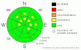
Danger Rose Tutorial
|
There are Pockets of MODERATE avalanche danger for fresh wind drifts, which will be found along upper elevation ridge lines and in open terrain. In addition, there are Pockets of MODERATE danger for triggering one of the increasingly large sluffs, which could catch and carry a person. |
|
|
CURRENT CONDITIONS |

|
Under clear skies, it’s a beautiful morning in the mountains – temperatures at the mid and upper elevations are in the mid 20s to near 30, while cold air trapped in the canyon bottoms by the inversion is chilly - in the low teens to near 10. Winds are currently light, from the northeast, but there was a brief increase in winds speeds overnight at the high elevations, with hourly averages in the 20 to 30 mph range for about 4 hours. |
|
|
RECENT ACTIVITY |

|
Long running sluffs, some trenching to the ground, were the prime avalanche activity yesterday. Triggers included slope cuts, explosives, and cornice drops. |
|
|
THREAT #1 |

|
| WHERE |
PROBABILITY |
SIZE |
TREND |
|
|
|
|
| |
|
|
Over the next
24 hours.
|
|
|
If you are heading to the highest peaks and ridges today, definitely check out the overnight winds. A few upper elevation stations had a short lived wind event last night, with averages in the 20s and 30s, which will have created a few sensitive drifts in the highest terrain. Our snow pack is so weak, even shallow, few inch thick wind drifts will be surprisingly sensitive. While the wind direction was mostly from the northeast, terrain will have channeled the wind in other directions, so the drifts could be on a variety of aspects.
A couple resources to check wind speeds include: Mesowest (http://www.wrh.noaa.gov/slc/gmap/ ) or the Snow/Avalanche page (http://www.wrh.noaa.gov/slc/snow/?area=cw . For example, Cascade Peak is representative of the highest elevations in the Provo area mountains, with 4 hours averaging in the 20s and 30s. |
|
|
THREAT #2 |

|
| WHERE |
PROBABILITY |
SIZE |
TREND |
|
|
|
|
|
|
Out of the wind affected terrain, though the avalanche danger is mostly low, the potential size of the long running sluffs is notable . Cornice drops are producing the largest sluffs, and these slides are big enough to take you for a ride and beat you up, and you definitely would not want to get hit from above by one. |
|
|
MOUNTAIN WEATHER |

|
It will be warm and sunny in the mountains today, with 10,000’ highs near 30, and 8,000’ highs in the low 40’s. The northeasterly winds will remain light, averaging less than 15 mph. Sunday’s weather will be a copy cat, and perhaps even a little warmer as the flow shifts to the southeast. Temperatures will cool Monday, and the jury (aka computer models) is still out on the chance for snow near the end of next week. |
|
|
This information does not apply to developed ski areas or highways where avalanche control is normally done. This advisory is from the U.S.D.A. Forest Service, which is solely responsible for its content. This advisory describes general avalanche conditions and local variations always occur. |
|
This advisory provided by the USDA Forest Service, in partnership with:
The Friends of the Utah Avalanche Center, Utah Division of State Parks and Recreation, Utah Division of Emergency Management, Salt Lake County, Salt Lake Unified Fire Authority and the friends of the La Sal Avalanche Center. See our Sponsors Page for a complete list. |
