Ogden Avalanche Advisory

Forecaster: Bruce Tremper

SPECIAL ANNOUNCEMENT

Note: with the combination of drought and smoggy conditions, we are telecommuting, which is why we don't answer our office phone. But we check the messages each morning. We have also dramatically cut back on field time to catch up on projects but we will update critical information most mornings on the web and phone lines.

We now have discount lift tickets available. Go to our Online Store or click this PURCHASE LINK to Backcountry.com who is distributing them for us.

You can show your support by purchasing UAC hardgoods (great xmas gifts!!) through our Online Store from the main menu above. We offer free shipping on everything.

WE WILL UPDATE THIS ADVISORY SATURDAY MORNING.


BOTTOM LINE

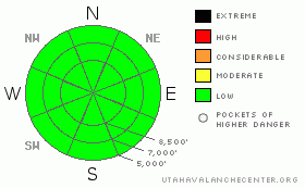
Danger by aspect and elevation on slopes approaching 35° or steeper.
(click HERE for tomorrow's danger rating)


Danger Rose Tutorial

Most terrain has a low avalanche danger, which never means no danger. You should use your usual bag of avalanche skills to deal with faceted snow sluffs on the steep, northerly facing slopes as well as old wind slabs on steep slopes in upper elevation wind exposed terrain.


CURRENT CONDITIONS

Luckily we have 2-3 inches of thin lipstick on our pig of a winter. But just beneath the facade of foof, you will find the usual wide variety of faceted snow, various kinds of crusts, and of course, lots of rocks. Snowmobilers are bogging down in the bottomless faceted snow just off the packed trails so you have to pick your play areas carefully. On most northerly-facing slopes, the snow is only 2 feet deep with almost no snow on south facing slopes. Very high elevations might have more snow.

Once again, you will find sunshine and warm up above the thick layer of valley stratus and smog. Daytime highs are around freezing and overnight lows are in the teens. Winds are calm.

Here is my quick tutorial that seems appropriate these days--the Smog Outdoor Exercise Guide:

First and most important, I check the Utah Air Quality Trend Charts each morning and concentrate on the top graph of PM 2.5 (the bad stuff). Those who live near the mountains can sometimes get lucky when the drainage air currents at night can push a pocket of fresh air out into the valleys near the canyon mouths. You can sometimes see that reflected in the trend charts.

Second, check the Meso West surface observations. When you see down canyon breezes in your local canyon. Since I live in Salt Lake, I check Parleys Canyon and the new weather station on the Utah Museum of Natural History, which sits at the bottom of Red Butte.

Third, get your exercise first thing in the morning because you will only have a short window of clean air at the base of the mountains before the daytime heating pushes it back up against the mountains.

Fourth, if you have the luxury of more time you can get up above the smog, but please take the bus or carpool so you don't add to the problem. And remember, Salt Lake has a no-idling rule.


RECENT ACTIVITY

No significant activity was reported yesterday. As always you can always check the Current Conditions section of our website for the full details.


THREAT #1

WHERE PROBABILITY SIZE TREND
      Over the next 24 hours.

Remember low danger never means no danger. Places where you can get into trouble today include being caught in a loose snow sluff of the weak faceted snow on steep slopes. You may also be able to find an isolated wind slab in the upper elevation wind exposed terrain that may crack out under your weight.


MOUNTAIN WEATHER

We should once again have sunny skies and warm temperature up above the valley fog and smog. Daytime highs should be near freezing with overnight lows in the teens and colder in the mountain valley bottoms where cold air pools. Winds will remain light.

For the extended forecast, unfortunately, we don't see any significant snow as far as the weather computer models can see, which is about 10 or 15 days.

But as they say, suffering is caused by attachment and desire. So just enjoy what comes your way.


GENERAL ANNOUNCEMENTS

If you trigger an avalanche in the backcountry - especially if you are adjacent to a ski area – please call the following teams to alert them to the slide and whether anyone is missing or not. Rescue teams can be exposed to significant hazard when responding to avalanches, and do not want to do so when unneeded. Thanks.

Salt Lake – Alta Central (801-742-2033)

Ogden – Snowbasin Patrol Dispatch (801-620-1017)

Provo – Sundance Patrol Dispatch (801-223-4150)

Dawn Patrol Forecast Hotline, updated by 05:30: 888-999-4019 option 8.

Daily observations are frequentlypostedby 10 pm each evening.

Subscribe to the daily avalanche advisory e-mail click HERE.

UDOT canyon closures UDOT at (801) 975-4838

Wasatch Powderbird Guides daily operations blog

You have the opportunity to participate in the creation of our own community avalanche advisory by submitting avalanche and snow observations. You can also call us at 801-524-5304 or 800-662-4140, or email by clicking HERE

Donate to your favorite non-profit –The Friends of the Utah Avalanche Center.The UAC depends on contributions from users like you to support our work.

The information in this advisory is from the U.S. Forest Service, which is solely responsible for its content. This advisory describes general avalanche conditions and local variations always occur.

We will update this forecast tomorrow morning. Thanks for calling.


This information does not apply to developed ski areas or highways where avalanche control is normally done.  This advisory is from the U.S.D.A. Forest Service, which is solely responsible for its content. This advisory describes general avalanche conditions and local variations always occur.


This advisory provided by the USDA Forest Service, in partnership with:

The Friends of the Utah Avalanche Center, Utah Division of State Parks and Recreation, Utah Division of Emergency Management, Salt Lake County, Salt Lake Unified Fire Authority and the friends of the La Sal Avalanche Center. See our Sponsors Page for a complete list.