SPECIAL ANNOUNCEMENT |
 |
More free avalanche awareness talks coming up: Friday Dec 9, 6 pm at White Pine Touring in Park City. Thursday, Dec 15, The Canyons Inn, 7-9pm, and Thursday, December 15, at the Salt Lake Surf Company, 7 pm.
For more upcoming events and more details, go to our Events listing from the main menu or our Classes-Workshops listing under Education from the main menu. |
|
|
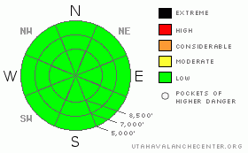
BOTTOM LINE
Danger by aspect and elevation on slopes approaching 35° or steeper.
(click HERE for tomorrow's danger rating)
|
Danger Rose Tutorial
|
The avalanche danger is generally LOW, but LOW danger does not mean no danger Small avalanches in isolated terrain are possible. Always approach steep slopes, especially at the upper elevations, with caution and think about consequences – if a small wind slab broke out beneath you or a loose snow sluff threw you off balance, could it send you off a cliff or into trees and rocks? |
|
|
CURRENT CONDITIONS |

|
Under clear skies, temperatures are in the teens and low twenties, and the northwesterly winds are light, with most stations averaging less than 15 mph. The highest peaks are occasionally gusting to 40.
The thin, sugary snowpack is generally less than 2 feet deep, necessitating a careful choice of packed roads and summer trails for access to and from the higher terrain. Turning and riding is surprisingly good in some spots, where there are loose facets over smooth terrain. However, in more and more places, the snowpack is so weak it’s becoming unsupportable and you tend to sink to the bottom, and at some point you will be hitting rocks. |
|
|
RECENT ACTIVITY |

|
It was very quiet yesterday, with only a few shallow facets sluffs and small rouge wind slabs triggered. |
|
|
THREAT #1 |

|
| WHERE |
PROBABILITY |
SIZE |
TREND |

|
|
|
|
| |
|
|
Over the next
24 hours.
|
|
|
LOW avalanche danger is isn’t the same a pushing the snooze button on your alarm, and drifting off into a dream. LOW danger means normal caution – be alert to your surroundings, still travel one at a time on steep slopes, think about escape routes, and identify the few isolated places where you could trigger a small hard wind drift or loose sluff. Be aware if you’re in a place where being knocked off balance or pushed could result in going for a ride off a cliff or into trees.
It is a great time to explore terrain and be building a mental map of the current snow distribution. Almost everything white out there is weak, and many of the areas with “not enough snow to ski or ride” today do have enough coverage to connect as a weak layer once it snows. |
|
|
MOUNTAIN WEATHER |

|
High pressure will continue to reign supreme through the weekend, resulting in clear skies, cool nights and warm days. Temperatures today will warm to near 30 at 8,000’ and into the low 20s at 10,000’. The northwesterly winds will add a bit of chill along the highest ridges, with averages of 15 to 25 mph, and occasional gusts to 40. If you look at the right computer models, there are faint glimmers of hope for later next week, with a trend toward a colder and more unsettled pattern – but that is far off in computer never-never land. |
|
|
GENERAL ANNOUNCEMENTS |
If you trigger an avalanche in the backcountry - especially if you are adjacent to a ski area – please call the following teams to alert them to the slide and whether anyone is missing or not. Rescue teams can be exposed to significant hazard when responding to avalanches, and do not want to do so when unneeded. Thanks.
Salt Lake – Alta Central (801-742-2033)
Ogden – Snowbasin Patrol Dispatch (801-620-1017)
Provo – Sundance Patrol Dispatch (801-223-4150)
Dawn Patrol Forecast Hotline, updated by 05:30: 888-999-4019 option 8.
Daily observations are frequently posted by 10 pm each evening.
Subscribe to the daily avalanche advisory e-mail click HERE.
UDOT canyon closures UDOT at (801) 975-4838
You have the opportunity to participate in the creation of our own community avalanche advisory by submitting avalanche and snow observations. You can also call us at 801-524-5304 or 800-662-4140, or email by clicking HERE
Donate to your favorite non-profit – The Friends of the Utah Avalanche Center. The UAC depends on contributions from users like you to support our work.
The information in this advisory is from the U.S. Forest Service, which is solely responsible for its content. This advisory describes general avalanche conditions and local variations always occur.
We will update this forecast tomorrow morning. Thanks for calling. |
|
|
This information does not apply to developed ski areas or highways where avalanche control is normally done. This advisory is from the U.S.D.A. Forest Service, which is solely responsible for its content. This advisory describes general avalanche conditions and local variations always occur. |
|
This advisory provided by the USDA Forest Service, in partnership with:
The Friends of the Utah Avalanche Center, Utah Division of State Parks and Recreation, Utah Division of Emergency Management, Salt Lake County, Salt Lake Unified Fire Authority and the friends of the La Sal Avalanche Center. See our Sponsors Page for a complete list. |
