BOTTOM LINE
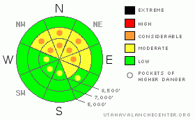
Danger by aspect and elevation on slopes approaching 35° or steeper.
(click HERE for tomorrow's danger rating)
|
Danger Rose Tutorial
|
POCKETS OF CONSIDERABLE avalanche danger remain on steep, northwest, north and northeasterly facing slopes above about 8,200’, especially where these slopes have been recently loaded with new drifts of wind blown snow. CONSIDERABLE means dangerous avalanche conditions exist and human triggered avalanches 1-3 ’deep and up to 200’ wide breaking on facets near the ground are possible, with serious consequences even if you’re not buried. And as always, avoid any steep slope with recent drifts of windblown snow.
Safer terrain does exist: in upper elevation, northerly facing terrain, head to the lower angle slopes, less steep than about 33 degrees that are not connected to steeper slopes directly above or to the sides, or to slopes without the layer of buried facets – generally those at mid and lower elevations and those facing the south ½ of the compass. |
|
|
CURRENT CONDITIONS |

|
It’s a warm and blustery morning - the southeast to southwesterly winds started cranking yesterday, and are still blowing in the 30 to 35 mph range, with gusts in the 50s and 60s across the highest terrain such as Mount Ogden. Even the mid elevations have gusts in the 40s and 50s. Temperatures remained warm all night - the lowest elevations were near 50, mid elevation stations in the low to mid 40s, and the ridgeline in the mid 30s.
Artful rock dodging remains a must with the shallow snowpack, and between wind, sun and heat damage, sheltered, shady, upper elevation slopes will have the best coverage and softest snow. |
|
|
RECENT ACTIVITY |

|
We have no recent reports of avalanches from the Ogden area mountains, however, there was some interesting activity in the SL mountains. Yesterday a large slab avalanche triggered by a natural cornice fall on the American Fork Twin. The slide pulled out this whole season’s snow, and the bed surface was a patch of left over snow from last winter. In addition, 1 large collapse was reported; there was another small cornice failure and sluffs are getting easy to trigger in the weak surface snow. |
|
|
THREAT #1 |

|
| WHERE |
PROBABILITY |
SIZE |
TREND |

|
|
|
|
| |
|
|
Over the next
24 hours.
|
|
|
Once again, we’re teasing those buried faceted weak layers – this time with wind transported snow. The southerly winds have been loading the exact slopes where the weak facets are buried near the ground, and while wind doesn’t load as evenly as a storm might, it is still efficient, and will have added weight to those slopes, pushing them closer to failure. Ogden snow profiles.
While there are some mixed messages on stability, focus on the results that show weak snow – yesterday’s large collapse, the slab avalanche and any snow pit tests showing weak snow with propagation and energy. These are of representative of where a person might trigger a slide. |
|
|
THREAT #2 |

|
| WHERE |
PROBABILITY |
SIZE |
TREND |
|
|
|
|
| |
|
|
Over the next
24 hours.
|
|
|
Expect to find sensitive cornices today, and give them a wide berth, as they often break back further than expected. There will also be drifts of windblown snow that should be avoided on any steep slope, found both along ridge lines and in open bowls at the higher and mid elevations. The drifts will become increasingly stubborn as the day goes on, and have a tendency to break out above you rather than at your feet. |
|
|
THREAT #3 |

|
| WHERE |
PROBABILITY |
SIZE |
TREND |
|
|
|
|
| |
|
|
Over the next
24 hours.
|
|
|
And one final detail - the surface snow is weakening on the shady northerly facing slopes, there are reports of increasingly large sluffs on steep slopes, which have just enough punch to carry a person. |
|
|
MOUNTAIN WEATHER |

|
After Thanksgiving, there are leftovers, and there are scraps. And only scraps is what we will be getting of the splitting storm system that is tracking across the Great Basin tonight and tomorrow. Today, temperatures will gradually cool, dropping into the upper teens by late tonight. The strong, southwesterly wind speeds should peak around dawn, and then also be on a downward trend today, decreasing into the 10 to 20 mph range as they shift to a westerly direction. Tomorrow, mostly cloudy skies, with 1 to 4” of snow possible. After that, it’s looking bad – a strong, warm ridge of high pressure will bring dry conditions through the weekend and well into next week. |
|
|
GENERAL ANNOUNCEMENTS |
If you trigger an avalanche in the backcountry - especially if you are adjacent to a ski area – please call the following teams to alert them to the slide and whether anyone is missing or not. Rescue teams can be exposed to significant hazard when responding to avalanches, and do not want to do so when unneeded. Thanks.
Salt Lake – Alta Central (801-742-2033)
Ogden – Snowbasin Patrol Dispatch (801-620-1017)
Provo – Sundance Patrol Dispatch (801-223-4150)
Dawn Patrol Forecast Hotline, updated by 05:30: 888-999-4019 option 8.
Daily observations are frequently posted by 10 pm each evening.
Subscribe to the daily avalanche advisory e-mail click HERE.
UDOT canyon closures UDOT at (801) 975-4838
You have the opportunity to participate in the creation of our own community avalanche advisory by submitting avalanche and snow observations. You can also call us at 801-524-5304 or 800-662-4140, or email by clicking HERE
Donate to your favorite non-profit – The Friends of the Utah Avalanche Center. The UAC depends on contributions from users like you to support our work.
The information in this advisory is from the U.S. Forest Service, which is solely responsible for its content. This advisory describes general avalanche conditions and local variations always occur.
We will update this forecast tomorrow morning. Thanks for calling. |
|
|
This information does not apply to developed ski areas or highways where avalanche control is normally done. This advisory is from the U.S.D.A. Forest Service, which is solely responsible for its content. This advisory describes general avalanche conditions and local variations always occur. |
|
This advisory provided by the USDA Forest Service, in partnership with:
The Friends of the Utah Avalanche Center, Utah Division of State Parks and Recreation, Utah Division of Emergency Management, Salt Lake County, Salt Lake Unified Fire Authority and the friends of the La Sal Avalanche Center. See our Sponsors Page for a complete list. |
