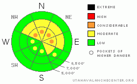
BOTTOM LINE
Danger by aspect and elevation on slopes approaching 35° or steeper.
(click HERE for tomorrow's danger rating)
|
Danger Rose Tutorial
|
The avalanche danger is MODERATE with Pockets of CONSIDERABLE on the steep, northwest through northeasterly facing slopes above about 8,500’, where there is weak, faceted snow from October and early November near the ground. Dangerous, human triggered avalanches are possible in this terrain. Also avoid any steep slope with new drifts of windblown snow, which will be found both along the higher ridgelines and well down into the mid elevation terrain on a variety of aspects.
Safer terrain does exist - slopes less steep than about 33 degrees that are not connected to steeper slopes directly above or to the sides, and slopes without the layer of buried facets – generally those at mid and lower elevations and those facing the south ½ of the compass. |
|
|
CURRENT CONDITIONS |

|
After a warm night under a southerly flow, temperatures finally cooled when the snow started falling again in the mountains. About an inch of snow has fallen in the Ogden mountians overnight, and temperatures are in the upper 20s. The southerly winds are currently in the 5 to 10 mph range, with the highest peaks averaging 20 - 25 mph.
The snow is slowly adding up and coverage improving, but don’t put away the rock boards yet! The small heavily rimed crystals are making bouncy turning and riding conditions. |
|
|
RECENT ACTIVITY |

|
The Cottonwoods were the center of avalanche activity yesterday, with 2 skier triggered slides. A smaller one on the Patsy Marley Ridge above Grizzly Gulch that broke near the ground, but did not catch the skier, and a very close call on north facing Pioneer Ridge, with a skier going for a ride after a 2-3 foot deep by 200’ wide slide broke above him. Facets were the culprit in both these incidents. There was also a snow cat triggered slide on an 11,000’ NE facing slope, 2 feet deep by 150’ wide, and a possible pocket “to the ground” on a northerly facing slope in upper Silver Fork.
Details can be found on the avalanche list, at Current Conditions – Avalanche List.
No new observations from the Ogden area mountains. |
|
|
THREAT #1 |

|
| WHERE |
PROBABILITY |
SIZE |
TREND |
|
|
|
|
| |
|
|
Over the next
24 hours.
|
|
|
Yesterday’s three or four incidents all have the common theme of occurring on steep, upper elevation northerly facing slopes and breaking near the ground on faceted snow. these weak layers are less widespread in the Ogden area mountians due to the lower overall elevations. But facets are tricky business, the facets just aren’t going to quit yet, and avoiding this terrain is an easy solution. With the weight of the additional new and wind drifted snow, I expect the faceted weak layer to remain sensitive to people today. Also, snow cascading down cliffs and rock bands has loaded specific slopes, too.
Avalanches failing on faceted weak layers can be remotely triggered, so be aware of what you are connected to, both above and to the sides. It is also noteworthy that many of these slides have been entraining snow far down the slide paths, so debris piles are deep…way deep enough to bury a person. |
|
|
THREAT #2 |

|
| WHERE |
PROBABILITY |
SIZE |
TREND |
|
|
|
|
| |
|
|
Over the next
24 hours.
|
|
|
Yesterday’s southwesterly wind event was a bit stronger than expected, with speeds averaging in the 25 to 30 mph range, and gusts into the 40s and 50s. The winds were blowing the snow into cracky drifts along ridges and well down into mid elevation terrain. With the way wind swirls in the mountains, watch and avoid for drifts not just on northerly facing slopes, but also cross loaded just about anywhere. Tel tale signs of sensitive wind drifts include cracking of the snow surface, also observe where the fresh cornices are and try jumping on small test slopes. |
|
|
MOUNTAIN WEATHER |

|
A weak disturbance will bring several more hours of snow this morning, with an additional 1 to 3” possible. Temperatures will warm to near 30 at 8,000’ and in the low 20s at 10,000’. The southwesterly wind speeds should remain less than yesterday – generally in the 5 to 15 mph range, with gusts below 25. The highest terrain could see wind gusts increase to near 40 mph at times. Tonight, skies will become partly cloudy, with temperatures dropping into the teens. High pressure will finally gain control tomorrow, and temperatures will warm Tuesday and Wednesday, followed by a weak, splitting storm Thursday night into Friday. |
|
|
GENERAL ANNOUNCEMENTS |
If you trigger an avalanche in the backcountry - especially if you are adjacent to a ski area – please call the following teams to alert them to the slide and whether anyone is missing or not. Rescue teams can be exposed to significant hazard when responding to avalanches, and do not want to do so when unneeded. Thanks.
Salt Lake – Alta Central (801-742-2033)
Ogden – Snowbasin Patrol Dispatch (801-620-1017)
Provo – Sundance Patrol Dispatch (801-223-4150)
Dawn Patrol Forecast Hotline, updated by 05:30: 888-999-4019 option 8.
Daily observations are frequently posted by 10 pm each evening.
Subscribe to the daily avalanche advisory e-mail click HERE.
UDOT canyon closures UDOT at (801) 975-4838
You have the opportunity to participate in the creation of our own community avalanche advisory by submitting avalanche and snow observations. You can also call us at 801-524-5304 or 800-662-4140, or email by clicking HERE
Donate to your favorite non-profit – The Friends of the Utah Avalanche Center. The UAC depends on contributions from users like you to support our work.
The information in this advisory is from the U.S. Forest Service, which is solely responsible for its content. This advisory describes general avalanche conditions and local variations always occur.
We will update this forecast tomorrow morning. Thanks for calling. |
|
|
This information does not apply to developed ski areas or highways where avalanche control is normally done. This advisory is from the U.S.D.A. Forest Service, which is solely responsible for its content. This advisory describes general avalanche conditions and local variations always occur. |
|
This advisory provided by the USDA Forest Service, in partnership with:
The Friends of the Utah Avalanche Center, Utah Division of State Parks and Recreation, Utah Division of Emergency Management, Salt Lake County, Salt Lake Unified Fire Authority and the friends of the La Sal Avalanche Center. See our Sponsors Page for a complete list. |
