AVALANCHE WATCH »
The risk of an avalanche is expected to increase significantly
but the timing and location are still uncertain. Stay tuned for updates.
|
 |
Notice: I am issuing an avalanche watch for increased avalanche danger for Saturday and Sunday because of the expected foot of snow with strong winds on Friday night. |
|
|
SPECIAL ANNOUNCEMENT |
 |
Park City Mountain Resort will begin control work in their high terrain Friday and Saturday, including McConkey’s, the Peak and the Jupiter area. Please avoid backcountry travel in those areas.
Alta and Snowbird resorts are closed to all touring and uphill traffic as they prepare to open for the season. |
|
|
BOTTOM LINE
Danger by aspect and elevation on slopes approaching 35° or steeper.
(click HERE for tomorrow's danger rating)
|
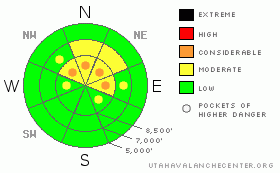
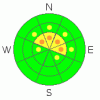
Danger Rose Tutorial
|
Same song, second verse. This weekend we should have similar pattern to last weekend but not quite as dangerous. In the mean time, today, the avalanche danger is MODERATE on slopes approaching 35 degrees or steeper that face northwesteast, north, northeast and east above about 9,500’, with Pockets of CONSIDERABLE on these same slopes. Avoid any steep slopes with recent wind deposits and even in non-wind drifted areas, you should stay on gentler terrain because of buried weak layers left over from October.
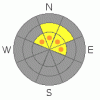
On Friday night through Sunday, depending on how much snow and wind we get, the avalanche danger may rise to Considerable with pockets of High. Monitor Saturday's advisory for the latest conditions. |
|
|
CURRENT CONDITIONS |

|
This morning, we will have the usual warm and windy conditions in advance of the cold front tonight. Ridge top temperatures have steadily climbed to near freezing. Ridge top winds are blowing hard from the southwest, 25-30, gusting to 50 and on the very exposed peaks, they are blowing 40-50, gusting over 60. |
|
|
RECENT ACTIVITY |

|
There were no reports of human triggered avalanches in the backcountry yesterday. |
|
|
THREAT #1 |

|
| WHERE |
PROBABILITY |
SIZE |
TREND |
|
|
|
|
| |
|
|
Over the next
24 hours.
|
|
|
With the strong winds today, we will have pockets of fresh, dense, wind slabs mostly along the upper elevation, wind exposed ridges. The winds are blowing hard from the southwest, which will load snow mostly onto the north through east facing slopes but cross loaded into other slopes as well. Today, you should definitely avoid any steep slope with recent deposits of wind drifted snow. You can recognize them easily by their smooth, rounded shape as opposed to the sandblasted look of wind eroded snow. Today's warm temperatures will hopefully limit the wind drifting but any drifts that do form, will be very dense, making them stubborn, yet dangerous. |
|
|
THREAT #2 |

|
| WHERE |
PROBABILITY |
SIZE |
TREND |
|
|
|
|
| |
|
|
Over the next
24 hours.
|
|
|
Unfortunately, the strong winds are drifting snow onto the exactly the slopes that have buried layers of faceted snow. This "persistent" weak layer formed in October and is now buried about a foot deep in most areas and about 1.5 feet deep in Little Cottonwood Canyon. This is the same layer responsible for 12 human triggered avalanches, one death and one broken femur at the unopened Little Cottonwood Canyon ski areas last Sunday. Although the layer is not quite as sensitive and now buried deeper than last Sunday, it is still there and in all my snowpit tests, it still reacts easily and propagates across the column. In other words, people can still trigger avalanches on this layer.
It's the usual, early season, damned if you do--damed if you don't pattern. There's mostly rocks on the south facing slopes. So it forces people onto the upper elevation slopes that face the north half of the compass because that's the only place where there's enough snow to ride. But these are the exact slopes that are dangerous because of both wind drifting and the buried layer of faceted snow.
The only escape from this dilema is to stick to gentler, north facing slopes--less steep than about 30 degrees. If you must get on steeper slopes, then go to a resort.
Final thought: The avalanche danger we forecast is a combination between probability and consequences. With such a thin snowpack, even a small avalanche has huge consequences because you will bounce down a nasty, rocky slope--like getting strained through shark teeth. In other words, what you might normally think of as a smaller, "manageable" avalanche is now life threatening. So take this into account. |
|
|
MOUNTAIN WEATHER |

|
Continued strong winds today from the southwest, 30 mph, gusting to 40 and on the exposed peaks, 50, gusting over 60. Temperatures will be warm, near freezing on the ridge tops. A stong cold front will arrive by late afternoon or early evening and by Saturday morning, we should have about a foot of new snow with a little less than an inch of water weight. Winds should continue to blow hard during the first part of the storm.
On Saturday and Sunday, we should have just scattered, light snow showers, partly cloudy skies, lighter winds and temperatures cooled down to the single digits. |
|
|
GENERAL ANNOUNCEMENTS |
If you trigger an avalanche in the backcountry - especially if you are adjacent to a ski area – please call the following teams to alert them to the slide and whether anyone is missing or not. Rescue teams can be exposed to significant hazard when responding to avalanches, and do not want to do so when unneeded. Thanks.
Salt Lake – Alta Central (801-742-2033)
Ogden – Snowbasin Patrol Dispatch (801-620-1017)
Provo – Sundance Patrol Dispatch (801-223-4150)
Dawn Patrol Forecast Hotline, updated by 05:30: 888-999-4019 option 8.
Daily observations are frequently posted by 10 pm each evening.
Subscribe to the daily avalanche advisory e-mail click HERE.
UDOT canyon closures UDOT at (801) 975-4838
You have the opportunity to participate in the creation of our own community avalanche advisory by submitting avalanche and snow observations. You can also call us at 801-524-5304 or 800-662-4140, or email by clicking HERE
Donate to your favorite non-profit – The Friends of the Utah Avalanche Center. The UAC depends on contributions from users like you to support our work.
The information in this advisory is from the U.S. Forest Service, which is solely responsible for its content. This advisory describes general avalanche conditions and local variations always occur.
We will update this forecast tomorrow morning. Thanks for calling. |
|
|
This information does not apply to developed ski areas or highways where avalanche control is normally done. This advisory is from the U.S.D.A. Forest Service, which is solely responsible for its content. This advisory describes general avalanche conditions and local variations always occur. |
|
This advisory provided by the USDA Forest Service, in partnership with:
The Friends of the Utah Avalanche Center, Utah Division of State Parks and Recreation, Utah Division of Emergency Management, Salt Lake County, Salt Lake Unified Fire Authority and the friends of the La Sal Avalanche Center. See our Sponsors Page for a complete list. |
