SPECIAL ANNOUNCEMENT |
 |
Alta and Snowbird resorts are closed to all touring and uphill traffic as they prepare to open for the season.
Little Cottonwood Canyon will be closed beneath Superior from 8-830 this morning for avalanche related work with UDOT. |
|
|
BOTTOM LINE
Danger by aspect and elevation on slopes approaching 35° or steeper.
(click HERE for tomorrow's danger rating)
|
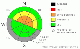
Danger Rose Tutorial
|
The avalanche danger remains CONSIDERABLE. Human triggered avalanches are still probable in the steep mid and upper elevation northwest through east facing slopes (exactly where there is the most snow for recreation). Avalanches are 1-2’ deep, but consequences of getting dragged into rocks, stumps, and trees is severe. Remotely triggered slides (that is, slides triggered at a distance) remain possible. Collapsing and cracking are immediate tell-tale signs of instability. The danger is LOW on slopes less than 30 degrees in steepness with nothing steeper above. |
|
|
CURRENT CONDITIONS |

|
We have mostly cloudy to overcast skies this morning and we’ll look to remain under a breezy cool moist northwest flow for the next day or so. Temperatures are in the low 20s and Mt. Ogden winds are from the west, blowing 30mph with gusts to 40. Snow coverage sits at 1-2’ at the mid to upper elevations. Riding conditions remain fair, if somewhat threadbare, and best on low angled slopes. It’s win-win in this terrain – safe –and skiers/snowboarders tend not to drag their ski/board tails through the rocks and stumps. Snowmobilers likely don’t have enough snow to access decent terrain. |
|
|
RECENT ACTIVITY |

|
Collapsing and a poor structure remain the headlines in the Ogden area mountains. Access is difficult to reach the high snow covered terrain, but conditions remain dangerous up high. In the Salt Lake mountians,
Backcountry activity continues to filter in, though it was nothing like the heyday on Sunday.
· A cornice drop in West Monitor along the Park City Ridgeline produced a small foot deep and 50’ wide pocket, running on the facets above the old October crust. This on a steep northeast slope at 10,000’.
· We also heard 2nd hand of a remotely or otherwise unintentionally triggered hard slab 2-3’ deep and 120’ wide in the Rocky Point terrain between Alta and Brighton ski areas. Later investigation had it, too, running on the weak faceted snow on the old October crust. This at 10,400’ on a steep northeast facing slope.
· A fresh-looking avalanche in the north headwall of the West Bowl of Silver Fork looks as if it may have been triggered remotely or by cornice fall.
· Ski areas continued to have widespread activity with explosive work, reporting that many avalanches further initiated other avalanches (something we call sympathetic trigger); with even hang fire (snow leftover above previous crowns) collapsing and pulling out with little provocation.
The accident reports can now be found under Current Conditions>Accidents. |
|
|
THREAT #1 |

|
| WHERE |
PROBABILITY |
SIZE |
TREND |
|
|
|
|
| |
|
|
Over the next
24 hours.
|
|
|
It’s just not the best way to start out the season. Days of cold and clear interspersed with minor storms is like building a house with a poor foundation. Saturday/Sunday’s storm was easily enough to overload this weak foundation, with widespread collapsing, early naturally running slides, and later very sensitive remote and human triggered avalanches. The early foundation did not adjust well to the wallop of snow. It’s still having trouble adjusting to that – and human weight. So – continued avalanching in these layers and corroborating stability tests along these weak interfaces should be enough to keep people on and below lower angled slopes. As with the large avalanche triggered by the tragic party in the mid-Cirque of Snowbird on Sunday, it was triggered from below, completely engulfing their ascending traverse – so consider the terrain above you. (See photos from accident report.)
A note on early season protocol. If touring in not-yet-opened ski areas, one must treat it as backcountry terrain. This relates to assessing each slope for stability, this relates to travel protocol. It was reported that skiers above were triggering snow down into Greeley Bowl (in the unopened Alta ski resort) as the ski patrol and Wasatch Backcountry Rescue were laboring to evacuate the patient who had sustained the fractured femur from an avalanche ride in the Gunsight. This is unacceptable. |
|
|
MOUNTAIN WEATHER |

|
A cool, moist northwest flow will be over the area through the week. We may see a trace to an inch of new in the mountains today. Winds will be 15-20mph from the west-northwest. Temps at 8000’ and 10,000’ will be in the upper and lower 20s, respectively. A warming trend kicks in mid-week ahead of what looks to be a fairly impressive storm set for Friday night into Saturday. Check our midday mountain weather forecast, found under Current Conditions>Mountain Weather. |
|
|
GENERAL ANNOUNCEMENTS |
If you trigger an avalanche in the backcountry - especially if you are adjacent to a ski area – please call the following teams to alert them to the slide and whether anyone is missing or not. Rescue teams can be exposed to significant hazard when responding to avalanches, and do not want to do so when unneeded. Thanks.
Salt Lake – Alta Central (801-742-2033)
Ogden – Snowbasin Patrol Dispatch (801-620-1017)
Provo – Sundance Patrol Dispatch (801-223-4150)
We appreciate all your avalanche and snow observations. You can submit information on our web site, (avalanche and snow observations), by calling 801-524-5304 or 800-662-4140, or email us at uac@utahavalanchecenter.org.
The information in this advisory is from the U.S. Forest Service, which is solely responsible for its content. This advisory describes general avalanche conditions and local variations always occur.
We will update this forecast tomorrow morning. Thanks for calling. |
|
|
This information does not apply to developed ski areas or highways where avalanche control is normally done. This advisory is from the U.S.D.A. Forest Service, which is solely responsible for its content. This advisory describes general avalanche conditions and local variations always occur. |
|
This advisory provided by the USDA Forest Service, in partnership with:
The Friends of the Utah Avalanche Center, Utah Division of State Parks and Recreation, Utah Division of Emergency Management, Salt Lake County, Salt Lake Unified Fire Authority and the friends of the La Sal Avalanche Center. See our Sponsors Page for a complete list. |
