SPECIAL ANNOUNCEMENT |
 |
It is still winter, with more storms on the way! Grab a couple of the six discount Sundance tickets that are left - reduced to $35! and support the Utah Avalanche Center. Discount Lift tickets |
|
|
BOTTOM LINE
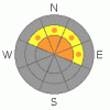
Danger by aspect and elevation on slopes approaching 35° or steeper.
(click HERE for tomorrow's danger rating)
|

Danger Rose Tutorial
|
Approach backcountry travel with caution today – if you’re on your game with careful snowpack evaluation, conservative decision making and choose a tour with lots of options, including terrain less steep than about 35 degrees, it will be a great day of powder snow. If you’re not quite as avy savvy, stay on wind sheltered, low angle terrain less steep than about 30 degrees.
The avalanche danger is Level 3 CONSIDERABLE for new and old wind drifts on northwest through easterly facing slopes, at mid and high elevations. The danger is Level 2 MODERATE for new snow sluffs and soft slabs, especially during periods of intense snowfall, and for damp sluffs with any sun or afternoon heating. It is also a Level 3 CONSIDERABLE for the chance of triggering a deeper slide on a faceted weak layer. |
|
|
CURRENT CONDITIONS |

|
Another cold spring snow storm is bringing full-on winter up high in the mountains. While the storm seemed to be just sputtering along yesterday, it finally kicked in overnight with about 7 inches in the Ogden and Provo area mountains, and another 2 to 5 inches in the Salt Lake and Park City area mountains,. This brings 24 hour snow totals close to a foot in the Ogden, Salt Lake, and Provo area mountains, with 3 day snow totals since Saturday pushing 2 feet in some locations.
Temperatures are wintery this morning - in the low teens at 10,000’. Yesterdays strong wind event is thankfully about over – currently most stations have westerly winds in the 10 to 15 mph range, with gusts to 25. The Ogden area mountains are the exception, still averaging 20 to 30 mph, with gusts in the 40’s and 50’s. |
|
|
RECENT ACTIVITY |

|
Yesterday, few people seemed to be braving the strong winds. In Banana Days, in Days Fork, a skier triggered a soft slab on a north facing slope, 18" deep by 100' wide that ran about 500' vertical. Initial ski cuts had been unproductive, and the slide released several turns below ridgeline at the skiers feet. In the Ogden area mountains, cornices and hard slabs continue to be very sensitive, and were triggered remotely from up to 100’ away. |
|
|
THREAT #1 |

|
| WHERE |
PROBABILITY |
SIZE |
TREND |

|
|
|
|
| |
|
|
Over the next
10 hours.
|
|
|
Wind Slabs: Very strong southerly winds yesterday and overnight created sensitive drifts on a wide range of aspects and elevations. Strong wind speeds mean drifts not just along the ridges, but down onto the slope, too, in open bowls and cross loaded along gully walls and breakovers. These older wind slabs will be stubborn today, harder to trigger and tending to break out above you, and to complicate matters, are now hidden beneath the newest snow.
Storm snow: Sluffs and soft slabs may be easy to trigger on steep slopes in the newest light snow, and particularly during any periods of heavy snowfall. |
|
|
THREAT #2 |

|
| WHERE |
PROBABILITY |
SIZE |
TREND |

|
|
|
|
| |
|
|
Over the next
10 hours.
|
|
|
It is spring, and every time it snows, the new snow will be very sensitive to any sun, thinning of the clouds, or day time heating. Expect damp snow sluffs to be easily triggered by afternoon on low to mid elevation slopes of all aspects. Roller balls are a first sign that the new snow is heating up and becoming damp. Avoid the common terrain traps such as gullies, where even a small sluff can pile up the snow deeply. |
|
|
THREAT #3 |

|
| WHERE |
PROBABILITY |
SIZE |
TREND |
|
|
|
|
| |
|
|
Over the next
24 hours.
|
|
|
Another loading event, another increase in the chance of a triggering a deeper slab avalanche – the remotely triggered slides in the Ogden area mountains indicate there may be another persistent weak layer higher in the snow pack that is sensitive, similar to one in the Logan area mountains.
In addition, deeper slides could be initiated with a larger trigger such as a new snow avalanche or cornice drop. An isolated deeper slide would be most likely on a heavily wind loaded, upper elevation northerly to easterly facing slope that is rocky or above cliffs so the snow slab has no support.
|
|
|
MOUNTAIN WEATHER |

|
Snow will continue most of the day, with the heaviest snow through about noon, then becoming more showery this afternoon. An additional 4 to 8” are possible on a mostly westerly flow. Winds will continue to decrease, into the 5 to 15 mph range at most stations, with just the highest peaks averaging closer to 25 mph, with gusts in the 30’s. Temperatures will warm to near 30 at 8,000’ and to near 20 at 10,000’. Partly cloudy skies tonight and Wednesday, with the next storm slated for Wednesday late night through Thursday. Additional storms are expected through the weekend. |
|
|
GENERAL ANNOUNCEMENTS |
GENERAL ANNOUNCEMENTS
If you trigger an avalanche in the backcountry - especially if you are adjacent to a ski area – please call the following teams to alert them to the slide and whether anyone is missing or not. Rescue teams can be exposed to significant hazard when responding to avalanches, and do not want to do so when unneeded. Thanks.
Salt Lake – Alta Central (801-742-2033)
Ogden – Snowbasin Patrol Dispatch (801-620-1017)
Provo – Sundance Patrol Dispatch (801-223-4150)
Discount Lift tickets: Ski Utah, Backcountry.com, Alta, Deer Valley, Park City, The Canyons, Wolf Mountain, Snowbasin, Beaver Mountain, Brighton, Sundance, and Solitude have donated a limited number of tickets for sale.
Wasatch Powderbird Guides flight plan.
Dawn Patrol Forecast Hotline, updated by 05:30: 888-999-4019 option 8.
Daily observations are frequently posted by 10 pm each evening.
Subscribe to the daily avalanche advisory e-mail click HERE.
UDOT canyon closures UDOT at (801) 975-4838
You have the opportunity to participate in the creation of our own community avalanche advisory by submitting avalanche and snow observations. You can also call us at 801-524-5304 or 800-662-4140, or email by clicking HERE
Donate to your favorite non-profit – The Friends of the Utah Avalanche Center. The UAC depends on contributions from users like you to support our work.
The information in this advisory is from the U.S. Forest Service, which is solely responsible for its content. This advisory describes general avalanche conditions and local variations always occur.
We will update this forecast tomorrow morning. Thanks for calling. |
|
|
This information does not apply to developed ski areas or highways where avalanche control is normally done. This advisory is from the U.S.D.A. Forest Service, which is solely responsible for its content. This advisory describes general avalanche conditions and local variations always occur. |
|
This advisory provided by the USDA Forest Service, in partnership with:
The Friends of the Utah Avalanche Center, Utah Division of State Parks and Recreation, Utah Division of Emergency Management, Salt Lake County, Salt Lake Unified Fire Authority and the friends of the La Sal Avalanche Center. See our Sponsors Page for a complete list. |
