SPECIAL ANNOUNCEMENT |
 |
On March 11th and 13th, the Utah Avalanche Center and SheJumps will team up to provide a Backcountry 101 class for women only. We will have a Friday night lecture and a Sunday field day to teach youthe basics of how to ski / ride avalanche smart in the Utah backcountry andgive you the confidence and skills to make good decisions for yourself and your group in the backcountry. Details here.
There are just a few lift tickets left - to Sundance and Wolf Mountain ski resorts – 100% of the sale of these donated tickets goes to support the Utah Avalanche. |
|
|
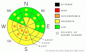
BOTTOM LINE
Danger by aspect and elevation on slopes approaching 35° or steeper.
(click HERE for tomorrow's danger rating)
|
Danger Rose Tutorial
|
· The avalanche is Moderate (Level 2) for wind drifts on mid and upper elevation slopes, especially those with an easterly component. Cornices are breaking back further than expected.
· As the day heats up, the danger of wet loose slides will increase to Moderate (Level 2) with Pockets of CONSIDERABLE in Ogden area mountains on steep sunny slopes and low elevation northerly facing slopes.
· And finally, there remain very isolated places where a person could trigger a large, deep avalanche, taking out several storms worth of snow, on higher elevation, north and northeasterly facing slopes, especially in rocky, thin terrain or shallow snowpack areas. These continue to rate a Moderate Danger due to their potential consequences. |
|
|
CURRENT CONDITIONS |

|
Yesterday was a “call in well” powder day for the Ogden area mountains, which received 10 to 15 inches of new snow. The rest of the range is settling for 2 to 6” storm totals, which is enough to cover many of the old sun and wind crusts, improving turning and riding conditions. Temperatures are in the mid teens to low twenties this morning, and the north westerly winds are light, with most stations averaging less than 15 mph. A few of the highest ridges are gusting to 30. |
|
|
RECENT ACTIVITY |

|
The only backcountry reports from yesterday were of a few easily triggered shallow soft wind drifts. But no reports from the Ogden area backcountry, that received the most snow. |
|
|
THREAT #1 |

|
| WHERE |
PROBABILITY |
SIZE |
TREND |

|
|
|
|
| |
|
|
Over the next
24 hours.
|
|
|
With plenty of snow to blow around, there were some sensitive wind drifts in the Ogden area mountains yesterday, and some should still be sensitive today. Avoid all steep, wind drifted slopes - consequences can be serious if you go for a ride off a cliff, into trees or you end up buried. Cornices are of two types – there will be some soft, new ones that are easy to release, but there have been releases of the large, old cornices over the past few days – breaking back much further than expected. Stay well back from the overhanging edges. Also watch for sluffing of the new snow on steep slopes, especially where the new snow did not bond well to the old. |
|
|
THREAT #2 |

|
| WHERE |
PROBABILITY |
SIZE |
TREND |

|
|
|
|
| |
|
|
Over the next
11 hours.
|
|
|
With rapidly clearing skies and lots of sun by late morning, I expect the new cold snow to be very sensitive to the sun and heat. In the Ogden area mountains, once the sun hits a steep slope, expect a roller ball derby, with rollers pin wheeling down the slope. Some of these will develop into damp sluffs, which could entrain snow resulting in sizable debris piles. Avoid steep terrain once the snow heats up, especially gullies and terrain traps like creek beds, where all the snow funnels into one deep pile. |
|
|
THREAT #3 |

|
| WHERE |
PROBABILITY |
SIZE |
TREND |

|
|
|
|
| |
|
|
Over the next
24 hours.
|
|
|
The deep, dangerous slabs that seem to be randomly popping out here and there… irritating is an understatement. The weak layers seem to be reactivated by rapid loading – wind events, cornice drops, and big storm loads. So I would expect the chance of triggering one of these deep, deadly slides is highest in the Ogden area mountains today. Elsewhere, you have to accept the fact that in very isolated areas, it is possible for a person to trigger a deep slab avalanche. You can reduce the chances by avoiding super steep slopes, those with shallow snow packs, rocky terrain and slopes that are unsupported below. Taking a look at photos on the avalanche list and being observant of the pattern of explosive released slides at the resorts will help to identify the type of terrain these slides are occurring in. |
|
|
MOUNTAIN WEATHER |

|
One last piece of the storm system is crossing the mountains early this morning, potentially adding another trace to 2 inches of snow. Skies will become clear this afternoon and tonight, as a ridge of high pressure builds in. Temperatures will warm to near 30 today at 8,000’ and remain in the mid teens at 10,000’. The northwesterly winds should remain light, averaging less than 20 mph. A few weak disturbances will cross northern Utah Saturday and Sunday, with light snow possible. A more potent storm is still on track for Monday into Tuesday. |
|
|
GENERAL ANNOUNCEMENTS |
If you trigger an avalanche in the backcountry - especially if you are adjacent to a ski area – please call the following teams to alert them to the slide and whether anyone is missing or not. Rescue teams can be exposed to significant hazard when responding to avalanches, and do not want to do so when unneeded. Thanks.
Salt Lake – Alta Central (801-742-2033)
Ogden – Snowbasin Patrol Dispatch (801-620-1017)
Provo – Sundance Patrol Dispatch (801-223-4150)
Discount Lift tickets: Ski Utah, Backcountry.com, Alta, Deer Valley, Park City, The Canyons, Wolf Mountain, Snowbasin, Beaver Mountain, Brighton, Sundance, and Solitude have donated a limited number of tickets for sale.
Wasatch Powderbird Guides flight plan.
Dawn Patrol Forecast Hotline, updated by 05:30: 888-999-4019 option 8.
Daily observations are frequently posted by 10 pm each evening.
Subscribe to the daily avalanche advisory e-mail click HERE.
UDOT canyon closures UDOT at (801) 975-4838
You have the opportunity to participate in the creation of our own community avalanche advisory by submitting avalanche and snow observations. You can also call us at 801-524-5304 or 800-662-4140, or email by clicking HERE
Donate to your favorite non-profit – The Friends of the Utah Avalanche Center. The UAC depends on contributions from users like you to support our work.
The information in this advisory is from the U.S. Forest Service, which is solely responsible for its content. This advisory describes general avalanche conditions and local variations always occur.
We will update this forecast tomorrow morning. Thanks for calling. |
|
|
This information does not apply to developed ski areas or highways where avalanche control is normally done. This advisory is from the U.S.D.A. Forest Service, which is solely responsible for its content. This advisory describes general avalanche conditions and local variations always occur. |
|
This advisory provided by the USDA Forest Service, in partnership with:
The Friends of the Utah Avalanche Center, Utah Division of State Parks and Recreation, Utah Division of Emergency Management, Salt Lake County, Salt Lake Unified Fire Authority and the friends of the La Sal Avalanche Center. See our Sponsors Page for a complete list. |
