SPECIAL ANNOUNCEMENT |
 |
Avalanche Control work in Little Cottonwood Canyon has been cancelled this morning.
There is still time to sign up for the 12 hours of Snowbird to be held this Friday. Bust out the lights to ski all night, rack up a vertical PR, and benefit the Utah Avalanche Center.
There are just a few lift tickets left - to Sundance, Wolf Mountain and Brianhead ski resorts – 100% of the sale of these donated tickets goes to support the Utah Avalanche Center. |
|
|
BOTTOM LINE
Danger by aspect and elevation on slopes approaching 35° or steeper.
(click HERE for tomorrow's danger rating)
|
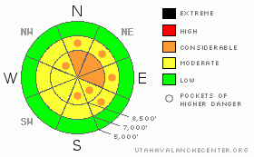
Danger Rose Tutorial
|
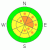
The avalanche danger is CONSIDERABLE (Level 3) on steep, wind drifted slopes, which will be found both along and well off the ridgelines. These sensitive drifts will be most widespread on northeast through southeasterly facing slopes. These same wind drifted slopes have a MODERATE (Level 2) danger of triggering a larger, deeper slide, breaking out on a faceted weak layer. The old catch 22 - lower probability, but much higher consequences. |
|
|
CURRENT CONDITIONS |

|
The fast moving, intense little storm that swept through last night dropped 4 to 8” of snow most places, with a swath of heavier snow – about 10” - from Powder Mountain to Farmington Canyon and Lookout Peak through mid Big Cottonwood and into upper Little Cottonwood. (Densities average 8 to 10 %.) Yesterday’s outrageously strong southerly winds decrease somewhat after frontal passage, but still averaged in the 20s and 30s, with gusts into the 50s, from the northwest. Currently, they are shifting back to a westerly direction and speeds are decreasing, with most stations in the 15 to 20 mph range, gusting to 30. But the highest peaks still have stronger winds, gusting to 50. Temperatures are in the single digits along the high ridge lines and in the teens at 8,000’. |
|
|
RECENT ACTIVITY |

|
No avalanche activity was reported yesterday. |
|
|
THREAT #1 |

|
| WHERE |
PROBABILITY |
SIZE |
TREND |
|
|
|
|
| |
|
|
Over the next
24 hours.
|
|
|
Unfortunately, the winds didn’t stop with the arrival of the snow. They switched to the northwest and were strong enough to blow and drift the snow both along the ridgelines and at the mid elevations. So wind drifts, or wind slabs, will be the number one issue to day. Expect sensitive drifts both along and well off the ridgelines, with snow cross loaded anywhere the wind speeds slow – gully walls and mid slope breakovers notorious places for wind drifts. The wind drifts could be 2 to 3 feet deep, and should be easily recognizable by their pillowy shape, and avoided on steep slopes. Jumping on test slopes will help you gauge their sensitivity, including depth and how wide they want to propagate. |
|
|
THREAT #2 |

|
| WHERE |
PROBABILITY |
SIZE |
TREND |
|
|
|
|
| |
|
|
Over the next
24 hours.
|
|
|
The more difficult problem will be gauging the sensitivity of the several more deeply buried persistent weak layers that exist on the northwest through east facing slopes, at the mid and upper elevations. These faceted weak layers will not give up their secrets easily – they vary widely over short distances. While days of warm temperatures and strong winds have strengthened these weak layers in many places, there a still a few places today where slides could fail on one of these faceted weak layers. The most likely place to trigger one of these deeper, dangerous avalanches will be on a wind drifted slope. It will be possible remotely trigger these slides from a distance, and any collapsing is a warning that this dangerous layering exists where you are.
Be extra suspicious of any shallower snow pack area where the January rain crust and associated facets are closer to surface, including wind scoured upper elevation slopes and areas that have received less snow since mid January,. |
|
|
THREAT #3 |

|
| WHERE |
PROBABILITY |
SIZE |
TREND |
|
|
|
|
| |
|
|
Over the next
24 hours.
|
|
|
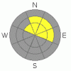
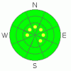
Out of wind affected areas, the avalanche danger is generally LOW, and I expect decent bonding of the new snow to the old, rough snow surfaces. But watch out for those few upper elevation, wind scoured areas where the new snow is landing directly on slick ice crusts. |
|
|
MOUNTAIN WEATHER |

|
Skies will be partly to mostly cloudy today, with hit and miss convective snow showers this afternoon producing a few more inches of snow. 10,000’ temperatures will remain in the single digits. Winds are in the process of shifting to the west southwest, and will continue to decrease into the 10 to 20 mph range at 9,000’, and 20 to 30 mph across the highest peaks and ridges, with gusts still in the 40s. Friday will be a break. The next storm this weekend will take a more southerly track, with smaller snow totals in the northern mountains. But with an active, progressive pattern forecast, the northern mountains will get another chance for decent shot of snow mid week. |
|
|
GENERAL ANNOUNCEMENTS |
If you trigger an avalanche in the backcountry - especially if you are adjacent to a ski area – please call the following teams to alert them to the slide and whether anyone is missing or not. Rescue teams can be exposed to significant hazard when responding to avalanches, and do not want to do so when unneeded. Thanks.
Salt Lake – Alta Central (801-742-2033)
Ogden – Snowbasin Patrol Dispatch (801-620-1017)
Provo – Sundance Patrol Dispatch (801-223-4150)
Discount Lift tickets: Ski Utah, Backcountry.com, Alta, Deer Valley, Park City, The Canyons, Wolf Mountain, Snowbasin, Beaver Mountain, Brighton, Sundance, and Solitude have donated a limited number of tickets for sale.
Wasatch Powderbird Guides flight plan.
Dawn Patrol Forecast Hotline, updated by 05:30: 888-999-4019 option 8.
Daily observations are frequently posted by 10 pm each evening.
Subscribe to the daily avalanche advisory e-mail click HERE.
UDOT canyon closures UDOT at (801) 975-4838
You have the opportunity to participate in the creation of our own community avalanche advisory by submitting avalanche and snow observations. You can also call us at 801-524-5304 or 800-662-4140, or email by clicking HERE
Donate to your favorite non-profit – The Friends of the Utah Avalanche Center. The UAC depends on contributions from users like you to support our work.
The information in this advisory is from the U.S. Forest Service, which is solely responsible for its content. This advisory describes general avalanche conditions and local variations always occur.
We will update this forecast tomorrow morning. Thanks for calling. |
|
|
This information does not apply to developed ski areas or highways where avalanche control is normally done. This advisory is from the U.S.D.A. Forest Service, which is solely responsible for its content. This advisory describes general avalanche conditions and local variations always occur. |
|
This advisory provided by the USDA Forest Service, in partnership with:
The Friends of the Utah Avalanche Center, Utah Division of State Parks and Recreation, Utah Division of Emergency Management, Salt Lake County, Salt Lake Unified Fire Authority and the friends of the La Sal Avalanche Center. See our Sponsors Page for a complete list. |
