SPECIAL ANNOUNCEMENT |
 |
There are just a few lift tickets left - to Sundance, Wolf Mountain and Brianhead ski resorts – 100% of the sale of these donated tickets goes to support the Utah Avalanche Center. |
|
|
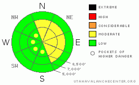
BOTTOM LINE
Danger by aspect and elevation on slopes approaching 35° or steeper.
(click HERE for tomorrow's danger rating)
|
Danger Rose Tutorial
|
The avalanche danger is LEVEL 2 (MODERATE) in steep terrain with recent deposits of wind drifted snow, which will be most widespread on north through southeasterly facing slopes at mid and upper elevations. There is also an isolated danger of a collapse triggering a deeper slide in the Ogden area mountians at the higher elevations on these same north through southeasterly facing slopes. Icy alpine conditions exist at the upper elevations – take care to avoid a slide for life off a cliff, into trees or a long ride. |
|
|
CURRENT CONDITIONS |

|
A weak disturbance raced through last night, dropping 2 to 3 inches of dense snow in the Ogden area mountains. Temperatures remained warm overnight, and are near 20 along the high ridge line, and in the upper 20's at the mid elevations. Many stations 5 to 10 degrees warmer than yesterday morning. The westerly winds have picked up, and mid elevation ridgelines are averaging 20 to 30 mph, with gusts in the 40’s. The high ridgelines are averaging 35 to 45 mph, with gusts into the 50’s.
Icy alpine conditions exist at the upper elevations, especially on wind scoured slopes. Depending on your project, equipment such as crampons, ice axes, a rope, ski crampons, and or whippets may be essential to preventing a slide for life or off a cliff. |
|
|
RECENT ACTIVITY |

|
There are no recent reports of avalanches form the Ogden area mountains. was a close call in Wolverine Cirque yesterday when a skier triggered a wind slab in steep, rocky terrain on a southeast facing slope - great photos and story here. A second wind slab was intentionally triggered in Snake Creek (photos later this morning – check the Avalanche List), also on a southeast facing slope, which ran on the rain crust. Blind infatuation with "strong" rain crust is about over – another 6 collapses were reported yesterday, some “tree shaking”, on slopes facing N, NE, E, and SE, with all but one above 9,000’. Sun also triggered the usual decent sized wet loose sluffs on steep sunny slopes. |
|
|
THREAT #1 |

|
| WHERE |
PROBABILITY |
SIZE |
TREND |

|
|
|
|
| |
|
|
Over the next
12 hours.
|
|
|
Warm, dense snow drifted by strong winds is landing on low density snow capped with a bit of surface hoar, creating sensitive wind drifts. Once running, any slide could entrain snow down to the crusts on some slopes, creating much deeper debris piles. The stronger overnight winds did not confine themselves to the ridgelines, but also got down into mid elevation terrain, so watch for sensitive drifts well off the ridgelines, on steep slopes at the mid elevations and for drifts cross loaded along gully walls and mid slope break overs. |
|
|
THREAT #2 |

|
| WHERE |
PROBABILITY |
SIZE |
TREND |

|
|
|
|
| |
|
|
Over the next
12 hours.
|
|
|
To quote Matt, one of our observers, there is “a complicated combination of structure and persistent weak layers”, in the form of rain or rime crust(s) above weak faceted snow, and more deeply buried surface hoar. So far, there have been no reports of collapsing from the Ogden area mountains, but observers have found the same ice crust and facet layering. Northeasterly through southeast facing slopes will have gotten a bit more than their fair share of snow today due to the winds, so use increasing caution on steep slopes at the upper elevations, especially those facing north through southeast. |
|
|
THREAT #3 |

|
| WHERE |
PROBABILITY |
SIZE |
TREND |

|
|
|
|
| |
|
|
Over the next
12 hours.
|
|
|
Out of the wind affected terrain, new snow sluffs on steep slopes will be possible, and if you’re in a place where the sun comes out or thin clouds heat the surface snow, damp sluffs will be possible, too. |
|
|
MOUNTAIN WEATHER |

|
After a bit of a break this morning, clouds will increase once again this afternoon, and instability showers could produce anywhere from a trace to 3 additional inches of snow. Temperatures will remain in the upper 20’s at 8,000’ and near 20 at 10,000’. The west to northwesterly winds will remain in the 20 to 30 mph range, with gusts in the 40’s through the morning hours, and then decrease this afternoon. The highest terrain could average to 45 mph, with gusts to 70. This northwesterly flow will continue through the weekend, with the next chance for stronger winds, and a few inches of snow, Sunday night. |
|
|
GENERAL ANNOUNCEMENTS |
If you trigger an avalanche in the backcountry - especially if you are adjacent to a ski area – please call the following teams to alert them to the slide and whether anyone is missing or not. Rescue teams can be exposed to significant hazard when responding to avalanches, and do not want to do so when unneeded. Thanks.
Salt Lake – Alta Central (801-742-2033)
Ogden – Snowbasin Patrol Dispatch (801-620-1017)
Provo – Sundance Patrol Dispatch (801-223-4150)
Discount Lift tickets: Ski Utah, Backcountry.com, Alta, Deer Valley, Park City, The Canyons, Wolf Mountain, Snowbasin, Beaver Mountain, Brighton, Sundance, and Solitude have donated a limited number of tickets for sale.
Wasatch Powderbird Guides flight plan.
Dawn Patrol Forecast Hotline, updated by 05:30: 888-999-4019 option 8.
Daily observations are frequently posted by 10 pm each evening.
Subscribe to the daily avalanche advisory e-mail click HERE.
UDOT canyon closures UDOT at (801) 975-4838
You have the opportunity to participate in the creation of our own community avalanche advisory by submitting avalanche and snow observations. You can also call us at 801-524-5304 or 800-662-4140, or email by clicking HERE
Donate to your favorite non-profit – The Friends of the Utah Avalanche Center. The UAC depends on contributions from users like you to support our work.
The information in this advisory is from the U.S. Forest Service, which is solely responsible for its content. This advisory describes general avalanche conditions and local variations always occur.
We will update this forecast tomorrow morning. Thanks for calling. |
|
|
This information does not apply to developed ski areas or highways where avalanche control is normally done. This advisory is from the U.S.D.A. Forest Service, which is solely responsible for its content. This advisory describes general avalanche conditions and local variations always occur. |
|
This advisory provided by the USDA Forest Service, in partnership with:
The Friends of the Utah Avalanche Center, Utah Division of State Parks and Recreation, Utah Division of Emergency Management, Salt Lake County, Salt Lake Unified Fire Authority and the friends of the La Sal Avalanche Center. See our Sponsors Page for a complete list. |
