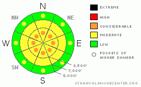
BOTTOM LINE
Danger by aspect and elevation on slopes approaching 35° or steeper.
(click HERE for tomorrow's danger rating)
|
Danger Rose Tutorial
|
At the upper elevations, the avalanche danger is a solid LEVEL 2 (MODERATE), with pockets of LEVEL 3 (CONSIDERABLE) for triggering deep dangerous slab avalanches on the buried faceted weak layers and for wind loaded graupel pools, which could also be on mid elevation slopes. At low and mid elevations, the avalanche danger is LEVEL 1 (LOW), with pockets of LEVEL 2 (MODERATE) for triggering wet sluffs with the heat of the day. |
|
|
CURRENT CONDITIONS |

|
Under partly cloudy skies, temperatures have dropped 10 to 15 degrees, putting an end to the liquid stuff. The high ridgelines are near 20, with the mid to low elevations in the twenties. Winds are from a westerly direction, and finally decreased, with most stations 10 to 15 mph, with a few gusting to 30 mph. However, many of the upper elevation stations are rimed, so wind speeds are inaccurate or nonexistent for the highest elevations.
Our rain saturated snow-scape is something else…there are smooth, ice rink rain crusts at the upper elevations, with some surprisingly decent turns on lower angle slopes where an inch or so of graupel stuck onto the ice. But, sharpen your edges and glue in your dentures for the sections of wind scoured bare ice sheets and rough frozen crusts at the mid and low elevations – slides for life are a concern on the steep, icy slopes. |
|
|
RECENT ACTIVITY |

|
There was a widespread wet sluff and wet slab avalanche cycle at the low through mid elevations, from Ogden to Provo (and HERE), especially on northerly facing slopes. Driving up the canyons you can see piles of wet debris in almost every steep gully.
Upper elevation slab avalanches occurred above about 10,000’ on all aspects. On west through north through east, naturals included a 500’ wide, 3 to 4’ deep slab in upper Little Cottonwood and smaller slabs 1 to 2’ deep in upper Big Cottonwood, 100 to 300’ wide. Today's better visibility should help fill in the details of the upper elevation slab avalanche cycle. In addition, avalanche control work in upper Little Cottonwood pulled out two very large slab avalanches, 2 to 4’ deep, up to 700’ wide on north and northeasterly facing slopes, above 10,500’. Little Cottonwood highway control work had good results on south facing slopes. |
|
|
THREAT #1 |

|
| WHERE |
PROBABILITY |
SIZE |
TREND |
|
|
|
|
| |
|
|
Over the next
24 hours.
|
|
|
The buried facets are still a serious issue at upper elevations – they are the culprit for yesterday’s largest avalanches, and human triggered deep dangerous slab avalanches are still possible today. Upper elevation snow pit tests yesterday still identify reactive buried surface hoar and near surface facets. Unfortunately, the strength of the ice layer and dense snow overlying the facets is very variable by both elevation and aspect, and this will make stability evaluation on the upper elevation slopes tricky. |
|
|
THREAT #2 |

|
| WHERE |
PROBABILITY |
SIZE |
TREND |
|
|
|
|
| |
|
|
Over the next
9 hours.
|
|
|
The cooling temperatures have put an end to the natural wet avalanche activity. But during the heat of the day, especially on steep sunny slopes and at the lower elevations, it may still be possible to trigger wet loose sluffs or even a frozen surface slab that fails on the wet snow beneath. So continue to avoid travel on the very steep mid and low elevation slopes, and especially avoid terrain traps such as gullies, creek beds and roads below steep banks. |
|
|
THREAT #3 |

|
| WHERE |
PROBABILITY |
SIZE |
TREND |
|
|
|
|
| |
|
|
Over the next
12 hours.
|
|
|
At upper elevations, yesterdays’s few inches of graupel pooled below steep icy slopes and were blown into dense drifts by the wind. It will be possible to trigger a few of these dense graupel drifts or pools in isolated places on moderate angle to steep slopes. Avoid both wind drifts and areas below steep slopes and cliffs where the graupel has pooled. |
|
|
MOUNTAIN WEATHER |

|
We’ll get a brief break between storms today, with periods of sun, before a shield of high thin clouds moves in. Temperatures will warm into the mid 30’s at 8,000’ and the mid 20’s at 10,000’. Winds will be westerly, and continue to gradually decrease into the 10 to 15 mph range, with the highest terrain gusting to 40 mph. Increasing clouds tonight, with temperatures dropping below freezing at all elevations. A final cold front will arrive Wednesday morning, bringing a brief, but intense period of snow, with storm totals of 6 to 10 inches possible. |
|
|
GENERAL ANNOUNCEMENTS |
If you trigger an avalanche in the backcountry - especially if you are adjacent to a ski area – please call the following teams to alert them to the slide and whether anyone is missing or not. Rescue teams can be exposed to significant hazard when responding to avalanches, and do not want to do so when unneeded. Thanks.
Salt Lake – Alta Central (801-742-2033)
Ogden – Snowbasin Patrol Dispatch (801-620-1017)
Provo – Sundance Patrol Dispatch (801-223-4150)
Discount Lift tickets: Ski Utah, Backcountry.com, Alta, Deer Valley, Park City, The Canyons, Wolf Mountain, Snowbasin, Beaver Mountain, Brighton, Sundance, and Solitude have donated a limited number of tickets for sale.
Wasatch Powderbird Guides flight plan.
Dawn Patrol Forecast Hotline, updated by 05:30: 888-999-4019 option 8.
Daily observations are frequently posted by 10 pm each evening.
Subscribe to the daily avalanche advisory e-mail click HERE.
UDOT canyon closures UDOT at (801) 975-4838
You have the opportunity to participate in the creation of our own community avalanche advisory by submitting avalanche and snow observations. You can also call us at 801-524-5304 or 800-662-4140, or email by clicking HERE
Donate to your favorite non-profit – The Friends of the Utah Avalanche Center. The UAC depends on contributions from users like you to support our work.
The information in this advisory is from the U.S. Forest Service, which is solely responsible for its content. This advisory describes general avalanche conditions and local variations always occur.
We will update this forecast tomorrow morning. Thanks for calling. |
|
|
This information does not apply to developed ski areas or highways where avalanche control is normally done. This advisory is from the U.S.D.A. Forest Service, which is solely responsible for its content. This advisory describes general avalanche conditions and local variations always occur. |
|
This advisory provided by the USDA Forest Service, in partnership with:
The Friends of the Utah Avalanche Center, Utah Division of State Parks and Recreation, Utah Division of Emergency Management, Salt Lake County, Salt Lake Unified Fire Authority and the friends of the La Sal Avalanche Center. See our Sponsors Page for a complete list. |
