BOTTOM LINE
Danger by aspect and elevation on slopes approaching 35° or steeper.
(click HERE for tomorrow's danger rating)
|
Danger Rose Tutorial
|
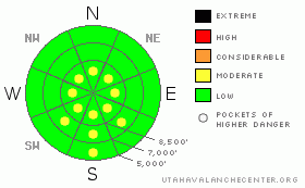
The avalanche danger is generally LEVEL 1 (LOW), with pockets of LEVEL 2 (MODERATE) danger for triggering a wind drift on steep slopes, which you will find near the high elevation ridges. There are also pockets of LEVEL 2 (MODERATE) for loose, wet sluffs on steep, sun exposed slopes especially in the heat of the day. |
|
|
CURRENT CONDITIONS |

|
It’s yet another day with warm, sunny skies up above the cold, choking smog in the valley. Be sure to take public transportation if you are headed to the mountains.
Smog in the valley goes hand-in-hand with the development of a very weak snow surface because the same conditions cause both. Most of the snow on the sun sheltered slopes has rotted away and to add insult to injury, a thick layer of sparkly surface hoar (frost) has formed on the snow surface. (See my photos from yesterday) This very weak snow makes for delightful riding conditions right now but after we slam a slab of snow down on top of it, we are going to have persistently nasty avalanche conditions. This is our first, significant weak layer of the season. So far we have had quite stable avalanche conditions but expect things to change in a hurry this coming week. So heads up. By mid week, strong winds are forecast to blow, which will make the avalanches rock-and-roll.
sun crusts and damp snow have formed on southerly facing slopes with wind-damaged snow up high along the ridges. |
|
|
RECENT ACTIVITY |

|
The only avalanche activity reported yesterday was damp to wet sluffs on steep, southerly facing slopes as they heated up in the strong sun. In the Salt Lake area mountains, on a couple of occasions, the sluffs crossed climbing tracks of skiers who had just made them. |
|
|
THREAT #1 |

|
| WHERE |
PROBABILITY |
SIZE |
TREND |

|
|
|
|
| |
|
|
Over the next
12 hours.
|
|
|
The warm temperatures and strong sun will continue to make localized areas of wet to damp sluffs on steep, sun exposed slopes as they heat up. |
|
|
THREAT #2 |

|
| WHERE |
PROBABILITY |
SIZE |
TREND |

|
|
|
|
| |
|
|
Over the next
24 hours.
|
|
|
There may be a few, lingering wind slabs at high elevations that people can still trigger. As always be cautious of steep slopes with deposits of wind drifted snow. |
|
|
MOUNTAIN WEATHER |

|
Today, like yesterday, will have warm, sunny weather up above the cold valley smog with the top of the inversion layer around 6,000’ in the morning rising to around 7,000’ in the afternoon. Ridge top temperatures will remain near freezing with light winds from the west, northwest.
A welcome, weekend cold front will arrive Saturday night to blow the smog away and give us 2-5 inches of fresh snow in the mountains. It will also bring in some very cold air with ridge top temperatures plunging below zero on Monday and Tuesday, when we could get a few more inches of snow. It appears that the cold front will arrive with fairly light winds, so it should preserve the weak surface snow we have right now and bury the weak layer intact. Yikes. Then we may get some stronger, northwesterly winds after the front on Sunday, which could make things interesting.
The extended forecast calls for roaring westerly winds by mid week, which will certainly bring lots of avalanche activity as wind slabs are deposited on top of the very weak snow we now have on the snow surface. |
|
|
GENERAL ANNOUNCEMENTS |
If you trigger an avalanche in the backcountry - especially if you are adjacent to a ski area – please call the following teams to alert them to the slide and whether anyone is missing or not. Rescue teams can be exposed to significant hazard when responding to avalanches, and do not want to do so when unneeded. Thanks.
Salt Lake – Alta Central (801-742-2033)
Ogden – Snowbasin Patrol Dispatch (801-620-1017)
Provo – Sundance Patrol Dispatch (801-223-4150)
Wasatch Powderbird Guides flight plan.
Dawn Patrol Forecast Hotline, updated by 05:30: 888-999-4019 option 8.
Daily observations are frequently posted by 10 pm each evening.
Subscribe to the daily avalanche advisory e-mail click HERE.
UDOT canyon closures UDOT at (801) 975-4838
You have the opportunity to participate in the creation of our own community avalanche advisory by submitting avalanche and snow observations. You can also call us at 801-524-5304 or 800-662-4140, or email by clicking HERE
Donate to your favorite non-profit – The Friends of the Utah Avalanche Center. The UAC depends on contributions from users like you to support our work. |
|
|
This information does not apply to developed ski areas or highways where avalanche control is normally done. This advisory is from the U.S.D.A. Forest Service, which is solely responsible for its content. This advisory describes general avalanche conditions and local variations always occur. |
|
This advisory provided by the USDA Forest Service, in partnership with:
The Friends of the Utah Avalanche Center, Utah Division of State Parks and Recreation, Utah Division of Emergency Management, Salt Lake County, Salt Lake Unified Fire Authority and the friends of the La Sal Avalanche Center. See our Sponsors Page for a complete list. |
