SPECIAL ANNOUNCEMENT |
 |
Discount Lift tickets: There are a few tickets left to Alta, Wolf Mountain, Sundance and Brian Head. Many thanks to Ski Utah, Backcountry.com and all the resorts that participated by donating tickets!
There is still space available in the next Backcountry 101 Avalanche Class. There is an evening session on January 6, with a field day on January 8th. Details at http://utahavalanchecenter.org/education |
|
|
BOTTOM LINE
Danger by aspect and elevation on slopes approaching 35° or steeper.
(click HERE for tomorrow's danger rating)
|
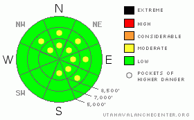
Danger Rose Tutorial
|
The avalanche danger is generally LEVEL 1 (LOW), with pockets of LEVEL 2 (MODERATE) danger for triggering a wind drift on steep slopes, with drifts most widespread on northeast, east and southeasterly facing slopes. There are also pockets of LEVEL 2 (MODERATE) for loose sluffs on steep, shady slopes. |
|
|
CURRENT CONDITIONS |

|
Under clear skies to partly cloudy skies, temperatures are once again in the low teens and single digits this morning, with the warmer Ogden area mountains in the mid to upper teens. Along the high ridges, the west to northwesterly winds averaged in the 20 to 30 mph range overnight, with gusts reaching into the 30’s and 40’s. The sun and wind protected shady slopes are where the powder is, with other slopes sporting sun and wind crusts. |
|
|
RECENT ACTIVITY |

|
Yesterday, there was one new soft slab triggered, 8” deep by 20 feet wide, running on surface hoar, on an easterly facing slope at 9,500’. There were numerous reports from around the range of easily triggered loose sluffs in the weakening surface snow that are large and running far. And finally, reports of a few isolated pockets of wind slab along the high Ogden area mountain ridgelines. Check Current Conditions and Avalanche List for photos of some of the large avalanches from last week’s cycle. |
|
|
THREAT #1 |

|
| WHERE |
PROBABILITY |
SIZE |
TREND |
|
|
|
|
| |
|
|
Over the next
12 hours.
|
|
|
With winds kicking up once again along the high ridgelines, watch out for and avoid the new drifts of windblown snow. Some of these drifts are landing on weak snow, including surface hoar, and may be quite sensitive. Wind drifts are rounded and pillowy deposits of snow, and will be most common today on slopes with an easterly facing component. |
|
|
THREAT #2 |

|
| WHERE |
PROBABILITY |
SIZE |
TREND |

|
|
|
|
| |
|
|
Over the next
24 hours.
|
|
|
The surface snow is weakening, and reports of surface hoar (check out surface hoar in the Avalanche Encyclopedia) are becoming more widespread. Loose snow sluffs are getting larger and running further in continuously steep terrain. While careful slope cuts are a good defense, use caution in terrain with higher consequences, such as when getting caught could take you off a cliff, into trees or for a long ride. |
|
|
MOUNTAIN WEATHER |

|
Another weak system in the northwest flow will cross northern Utah today and tonight, bringing a chance for a trace to a couple inches of snow. Clouds are rapidly increasing this morning, and the west to northwesterly winds will kick up a bit today, with 30 to 40 mph averages and gusts to 60 possible along the highest ridges. Elsewhere, 10 to 20 mph averages, with gusts to 30, will be more common. Temperatures will warm into the upper 20’s at 8,000’, and to near 20 along the high ridges. High pressure on Thursday and Friday will be followed by a nice cold storm on Saturday with a decent shot of snow possible. |
|
|
GENERAL ANNOUNCEMENTS |
If you trigger an avalanche in the backcountry - especially if you are adjacent to a ski area – please call the following teams to alert them to the slide and whether anyone is missing or not. Rescue teams can be exposed to significant hazard when responding to avalanches, and do not want to do so when unneeded. Thanks.
Salt Lake – Alta Central (801-742-2033)
Ogden – Snowbasin Patrol Dispatch (801-620-1017)
Provo – Sundance Patrol Dispatch (801-223-4150)
Wasatch Powderbird Guides flight plan.
Dawn Patrol Forecast Hotline, updated by 05:30: 888-999-4019 option 8.
Daily observations are frequently posted by 10 pm each evening.
Subscribe to the daily avalanche advisory e-mail click HERE.
UDOT canyon closures UDOT at (801) 975-4838
You have the opportunity to participate in the creation of our own community avalanche advisory by submitting avalanche and snow observations. You can also call us at 801-524-5304 or 800-662-4140, or email to uac@utahavalanchecenter.org
Donate to your favorite non-profit – The Friends of the Utah Avalanche Center. The UAC depends on contributions from users like you to support our work. |
|
|
This information does not apply to developed ski areas or highways where avalanche control is normally done. This advisory is from the U.S.D.A. Forest Service, which is solely responsible for its content. This advisory describes general avalanche conditions and local variations always occur. |
|
This advisory provided by the USDA Forest Service, in partnership with:
The Friends of the Utah Avalanche Center, Utah Division of State Parks and Recreation, Utah Division of Emergency Management, Salt Lake County, Salt Lake Unified Fire Authority and the friends of the La Sal Avalanche Center. See our Sponsors Page for a complete list. |
