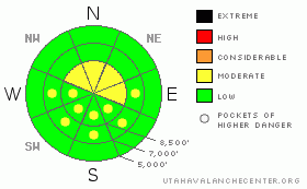
BOTTOM LINE
Danger by aspect and elevation on slopes approaching 35° or steeper.
(click HERE for tomorrow's danger rating)
|
Danger Rose Tutorial
|
The avalanche danger is Level 2 (MODERATE) on any slope approaching 35 degrees or steeper with recent deposits of wind drifted snow, which you will find mainly near the upper elevation ridges. You will also find a Level 2 (MODERATE) danger on any steep slope being rapidly warmed by the sun. Otherwise, the danger is mostly Level 1 (Low). |
|
|
CURRENT CONDITIONS |

|
Today should be a great day to get in the mountains and do some early holiday shopping for powder—a gift to yourself, in this case. Temperatures are leaping up the chart and have risen 20-30 degrees. Ogden Peak rose from a mighty-chilly -10 yesterday morning to 15 above this morning and it should warm into the mid 20's today. Skies should be clear with calm winds.
The phrase I keep hearing over and over, including from me: “This is the best early season snowpack I can remember.” |
|
|
RECENT ACTIVITY |

|
Not much activity yesterday. The only activity we heard about was in the Salt Lake area mountains: There were a couple class 3 releases with explosives in Little Cottonwood Canyon Just below 11,000’ on East and Northwest facing slopes. These were wind slabs on a thin, rocky slope.
Someone also reported a natural glide avalanche in Broad’s Fork in the usual location—the steep rock slabs of the Diving Board and in Bonkers, which broke to the ground and 50-100 feet wide (report). These glide avalanches occur regularly in that location and I don’t think they represent conditions in the rest of the backcountry. Otherwise, there were quite a few volunteer stability testers out yesterday with no avalanches triggered. |
|
|
THREAT #1 |

|
| WHERE |
PROBABILITY |
SIZE |
TREND |
|
|
|
|
| |
|
|
Over the next
24 hours.
|
|
|
I like to make fact-based decisions. The alternative, of course, is to gamble with your life, which is a bonehead move at best. As the facts come in, we start to see a pattern. So it’s the pattern of the facts which keep us safe.
I have dug quite a few snowpits in the last couple days in Little and Big Cottonwood Canyons and I found very stable snow in all my holes. This either means that the snowpack really is stable or I have not looked in the right places. Most other observers have found the same thing, which makes me feel better. But good avalanche forecasters are like good stock traders—the best ones always look for the downside. In other words, where can I find an avalanche today?
The most likely place would be a recently wind drifted slope with a thin snowpack, which you will find mostly near the upper elevation ridges. As always, you should be suspicious of steep slopes with recent deposits of wind drifted snow. The rapid warming today may reactivate some of these slabs, which have been stubborn and stiff during these past couple days of cold. |
|
|
THREAT #2 |

|
| WHERE |
PROBABILITY |
SIZE |
TREND |
|
|
|
|
| |
|
|
Over the next
12 hours.
|
|
|
I don’t know what to call this second avalanche problem but we may see some avalanches today from rapid warming of the snow surface, which has been in the deep freeze these past couple days. Be suspicious of any slope approaching 35 degrees or steeper that is being rapidly warmed by the sun, especially in thin snowpack areas. |
|
|
MOUNTAIN WEATHER |

|
Today should be warm and sunny with temperatures in the mid to upper 20’s. Winds should remain light. Same deal on Saturday. On Saturday night we have another storm on tap, which should freshen our snow on Sunday with perhaps another foot of snow. Then, we have another disturbance of some kind around December 2nd and 3rd. |
|
|
GENERAL ANNOUNCEMENTS |
GENERAL ANNOUNCEMENTS
Soon! Discount Lift tickets: Ski Utah, Backcountry.com, Alta, Deer Valley, Park City, The Canyons, Wolf Mountain, Snowbasin, Beaver Mountain, Brighton, Sundance, and Solitude have donated a limited number of tickets for sale at discounted prices.
Dawn Patrol Forecast Hotline, updated by 05:30: 888-999-4019 option 8.
Daily observations are frequently posted by 10 pm each evening.
Free UAC iPhone app from Canyon Sports.
Subscribe to the daily avalanche advisory e-mail click HERE.
UDOT canyon closures UDOT at (801) 975-4838
We appreciate all your avalanche and snow observations. You can also call us at 801-524-5304 or 800-662-4140, or email to uac@utahavalanchecenter.org
Donate to your favorite non-profit – The Friends of the Utah Avalanche Center. The UAC depends on contributions from users like you to support our work.
The information in this advisory is from the U.S. Forest Service, which is solely responsible for its content. This advisory describes general avalanche conditions and local variations always occur.
We will update this forecast tomorrow morning. Thanks for calling. |
|
|
This information does not apply to developed ski areas or highways where avalanche control is normally done. This advisory is from the U.S.D.A. Forest Service, which is solely responsible for its content. This advisory describes general avalanche conditions and local variations always occur. |
|
This advisory provided by the USDA Forest Service, in partnership with:
The Friends of the Utah Avalanche Center, Utah Division of State Parks and Recreation, Utah Division of Emergency Management, Salt Lake County, Salt Lake Unified Fire Authority and the friends of the La Sal Avalanche Center. See our Sponsors Page for a complete list. |
