AVALANCHE WARNING »
Dangerous avalanche conditions are occuring or are imminent.
Backcountry travel in avalanche terrain is not recommended.
|
 |
Notice: An Avalanche Warning has been issued for the Wasatch, Western Uintas and Bear River Ranges. Recent snow and strong winds have created sensitive avalanche conditions along high elevation ridges. The danger is most pronounced above about 9000 feet in elevation. To stay out of avalanche danger, do not travel in terrain approaching 35 degrees in steepness with recent deposits of wind drifted snow. People without expert level snow and avalanche assessment skills should avoid backcountry travel today. |
|
|
BOTTOM LINE
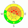
Danger by aspect and elevation on slopes approaching 35° or steeper.
(click HERE for tomorrow's danger rating)
|

Danger Rose Tutorial
|
The avalanche danger is level 3 (Considerable) in any wind exposed terrain especially along northerly facing upper elevation ridges above around 9000 feet. With additional snow and winds during the day the danger may reach level 4 (High) with the potential of natural avalanching. To stay out of avalanche danger, do not travel in terrain approaching 35 degrees in steepness with recent deposits of wind drifted snow. People without expert level snow and avalanche assessment skills should avoid backcountry travel today. |
|
|
CURRENT CONDITIONS |

|
Temperatures are in the mid 20s at most mountain locations. Winds tapered way off overnight but look like they’re on the increase again. We have gusts in the 20 mph range along the mid elevation ridges and near 50 at the more exposed locations from the southwest. 24 hr snow totals are as follows: Little Cottonwood 12” with 1.5” H2O, Brighton 17” with 2.5” H2O, Spruces 10” with 1.2” H2O, Park City Ridgeline 14” with 1.9” H2O, Provo area and about a foot with 1.7” H2O, The Ogden area is in the 5 to 7” range with around a half inch of water. |
|
|
RECENT ACTIVITY |

|
There was no avalanche activity reported from the Ogden area on Saturday. Skiers remotely triggered a couple of pockets along the DAYS FORK and SILVER FORK ridgeline on Saturday. These were in very wind loaded terrain. One averaged 12 inches deep and was 30 feet wide and ran 150’. The more significant one was up to 6 feet deep and ran about 500 feet vertical. Out of the wind exposed terrain, things were drastically less sensitive. |
|
|
THREAT #1 |

|
| WHERE |
PROBABILITY |
SIZE |
TREND |
|
|
|
|
| |
|
|
Over the next
24
hours.
|
|
|
Wind loading is by far the biggest factor to be concerned with today. Winds deposit snow much faster then it can fall out of the sky and can rapidly add too much weight even for a moderately strong snowpack. Spotty areas with preexisting weak snow compound this issue. A rime crust with facets below could play a role as we add snow on top of it. Winds have already deposited large amounts of snow along the ridges over the last 24 hours and I’d expect to see more during the day today. It’s best not to mess around with these drifts today. If you stay out of the wind exposed terrain you’ll find that things are much less sensitive and you most likely won’t see that many signs of instability. |
|
|
THREAT #2 |

|
| WHERE |
PROBABILITY |
SIZE |
TREND |

|
|
|
|
| |
|
|
Over the next
24
hours.
|
|
|
A secondary concern today is the new snow itself. As with any storm as it’s happening you need to pay attention to the layering within the new snow. You’re looking for any weakness that may form as the snow falls. Handpits, shovel tilt tests and ski cuts often reveal any weakness within the new snow. This type of weakness is often short lived but also the most sensitive during the height of snowfall which will include a good portion of today. |
|
|
MOUNTAIN WEATHER |

|
We’ll have snow increasing as the morning progresses and continuing through the day. Another foot of snow or more is not out of the question. Winds will continue to blow in the moderate to strong category from the southwest. Temperatures will be in the low to mid 20s. Snow will continue through Tuesday or into Wednesday with another pronounced storm feature on Tuesday. |
|
|
This information does not apply to developed ski areas or highways where avalanche control is normally done. This advisory is from the U.S.D.A. Forest Service, which is solely responsible for its content. This advisory describes general avalanche conditions and local variations always occur. |
|
This advisory provided by the USDA Forest Service, in partnership with:
The Friends of the Utah Avalanche Center, Utah Division of State Parks and Recreation, Utah Division of Emergency Management, Salt Lake County, Salt Lake Unified Fire Authority and the friends of the La Sal Avalanche Center. See our Sponsors Page for a complete list. |
