SPECIAL ANNOUNCEMENT |
 |
Artillery firing on south facing slopes above Town of Alta TODAY starting at 6:30 am. STAY CLEAR OF ALL AREAS between Superior and Grizzly gulch until work is finished around 8:30 am. |
|
|
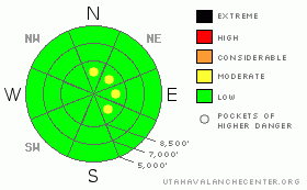
BOTTOM LINE
Danger by aspect and elevation on slopes approaching 35° or steeper.
(click HERE for tomorrow's danger rating)
|
Danger Rose Tutorial
|
There are pockets of a Level 2 (MODERATE) avalanche danger on steep slopes in wind exposed terrain, where avalanches 1 to 2 feet deep can be triggered on steep, wind drifted slopes. These drifts are most widespread on north through southeast facing slopes, at both mid and upper elevations. Out of wind exposed terrain the danger is Level 1 (LOW). |
|
|
CURRENT CONDITIONS |

|
There are cloudy skies, warm temperatures and strong southwesterly winds this morning – all the classic signs of a storm on its way. Temperatures in the Ogden area mountains are currently near 40 at the low an mid elevations, with the highest ridges near 30. The southwesterly winds along the highest ridges have been averaging 30 to 40 mph, with gusts 50 to 60. Down off the ridgelines, speeds are substantially lower, though expected to increase later today and tonight. The battered old snow surface will continue to get pummeled for the next 24 hours by the winds – it’s a mosaic of dense wind drifts and thin crusts in exposed areas, with good turns to be found in more wind sheltered areas in dense, creamy or bouncy snow. |
|
|
RECENT ACTIVITY |

|
Control work at the Cottonwood Canyon resorts released 10 to 24” isolated pockets up to 70’ wide in wind affected terrain yesterday. No new avalanches were reported from the backcountry, however, there’s a great observation of a slide that probably occurred on the 16th (current conditions observation). It’s a good example of what strong winds can do with even small amounts of snow. |
|
|
THREAT #1 |

|
| WHERE |
PROBABILITY |
SIZE |
TREND |

|
|
|
|
| |
|
|
Over the next
24 hours.
|
|
|
The winds have the potential to be huge for the next 24 hours. They will continue to drift snow, even though there is a certain lack of enthusiasm in the snow grains as they make their third move in four days. Still, watch out for and avoid any new and old drifts of windblown snow on steep slopes, where there is the possibility of triggering an avalanche in isolated terrain. Stay back from corniced ridges, watch for cracking of the snow surface, and jump around on test slopes to check the sensitivity of the drifts. Expect some drifts well off the ridge lines, due to the high wind speeds, and for drifts to be loaded along the sides of gullies and on mid slope breakovers.
Also continue to probe down in the snow – weaker buried layers and poor bonding between layers may make the next avalanche cycle more than just new snow. The rain/rime crust is confirmed in the Snowbasin area and on Bountiful Peak. We don't have reports from Ben Lomond or the Powder mountian area yet. Due to the shallower snowpack in the Ogden area mountains, the weak layer beneath the rain/rime crust seems to be weaker than in the Cottonwoods. There’s lots of variation throughout individual slopes, drainages, and the range, which will make the avalanche situation trickier. |
|
|
MOUNTAIN WEATHER |

|
Excitement continues to build, as the weather models continue to advertise four days of increasingly colder storms, with the first storm arriving tomorrow, Saturday. Today, ahead of this system, skies will be mostly cloudy and southwesterly winds steady in the 25 to 35 mph range, with gusts into the 50’s. In the most exposed terrain, averages to 45 mph, with gusts into the 60’s are forecast. Temperatures will be warm, in the low 30’s to low 40’s.
Today’s winds are just warming up today for tonight’s performance, when speeds are forecast to increase, with gusts to 80 mph along the highest ridges, potentially lasting well into Saturday. Light snow fall should begin tomorrow morning, with the first strong cold front passage currently timed for Saturday afternoon/early evening with intense snowfall expected. The second strong cold front brings more of the same Sunday afternoon...with a final wave anticipated for Monday afternoon into Tuesday. Storm total snowfall expected to be measured in feet by Wednesday morning. |
|
|
GENERAL ANNOUNCEMENTS |
Please contact Alta Central (801-742-2033) if you trigger a large avalanche in the backcountry - especially if you are adjacent to a ski area - to alert them to the slide and whether anyone is missing or not. Rescue teams can be exposed to significant hazard when responding to avalanches, and do not want to do so when unneeded. Thanks.
Soon! Discount Lift tickets: Ski Utah, Backcountry.com, Alta, Deer Valley, Park City, The Canyons, Wolf Mountain, Snowbasin, Beaver Mountain, Brighton, Sundance, and Solitude have donated a limited number of tickets for sale at discounted prices.
Wasatch Powderbird Guides flight plan.
Dawn Patrol Forecast Hotline, updated by 05:30: 888-999-4019 option 8.
Daily observations are frequently posted by 10 pm each evening.
Free UAC iPhone app from Canyon Sports.
Subscribe to the daily avalanche advisory e-mail click HERE.
UDOT canyon closures UDOT at (801) 975-4838
We appreciate all your avalanche and snow observations. You can also call us at 801-524-5304 or 800-662-4140, or email to uac@utahavalanchecenter.org
Donate to your favorite non-profit – The Friends of the Utah Avalanche Center. The UAC depends on contributions from users like you to support our work.
The information in this advisory is from the U.S. Forest Service, which is solely responsible for its content. This advisory describes general avalanche conditions and local variations always occur.
We will update this forecast tomorrow morning. Thanks for calling. |
|
|
This information does not apply to developed ski areas or highways where avalanche control is normally done. This advisory is from the U.S.D.A. Forest Service, which is solely responsible for its content. This advisory describes general avalanche conditions and local variations always occur. |
|
This advisory provided by the USDA Forest Service, in partnership with:
The Friends of the Utah Avalanche Center, Utah Division of State Parks and Recreation, Utah Division of Emergency Management, Salt Lake County, Salt Lake Unified Fire Authority and the friends of the La Sal Avalanche Center. See our Sponsors Page for a complete list. |
