BOTTOM LINE
Danger by aspect and elevation on slopes approaching 35° or steeper.
(click HERE for tomorrow's danger rating)
|
Danger Rose Tutorial
|
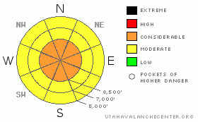
The avalanche danger is LEVEL 3 (CONSIDERABLE) on most slopes above about 8,500’ steeper than about 35 degrees with over 6 inches of new snow, especially in wind-affected terrain. The danger is LEVEL 2 (MODERATE) on slopes below about 8,500 and on slopes with less than about 6 inches of new snow overnight. |
|
|
CURRENT CONDITIONS |

|
What a difference a day makes. Overnight, a very windy storm plopped down 10 inches of very heavy, dense graupel in Little Cottonwood Canyon, which weighs in at a whopping 20 percent water weight. The wind is blowing hard from the northwest 30, gusting to 40 and the winds are getting down into the mountain valleys. Little Cottonwood seems to have the most snow with 24-hour totals of a foot with about 3-6 inches outside of Little Cottonwood but the density remains very hefty with strong wind. |
|
|
RECENT ACTIVITY |

|
The cat drivers this morning in Little Cottonwood Canyon were reporting lots of slab avalanches and one avalanche worker checking their weather station this morning reported inverted wind slabs that were “energetic, widespread and unforgiving.” Enough said. |
|
|
THREAT #1 |

|
| WHERE |
PROBABILITY |
SIZE |
TREND |

|
|
|
|
| |
|
|
Over the next
24 hours.
|
|
|
Today will be very different than yesterday. Expect widespread areas of sensitive, dense slabs today especially at elevations above about 8,500’ and especially in downwind terrain. Luckily, all the avalanche problems are right near the surface and obvious. It should be a fun day to jump on small test slopes—say 10 feet high and not connected to a steep, large slope above. You can turn these conditions into a fun learning experience. But under no circumstances should you get on larger, steep slopes especially at upper elevations. These are dangerous conditions.
These dense slabs will break out on a density inversion within the new snow overnight and also run on a thin rime crust that came down yesterday. |
|
|
MOUNTAIN WEATHER |

|
The National Weather Service has issued a Winter Storm Warning for the Wasatch Mountains with 12-20 inches of additional snow expected by Tuesday morning. We may see a slight letup in the wind and snow later this morning but we should get another, similar shot this afternoon and tonight. Ridge top temperatures will be in the mid 20’s today with continued strong wind from the northwest 20-30, gusting to 40 and even stronger winds forecast for Tuesday. |
|
|
GENERAL ANNOUNCEMENTS |
For an avalanche education class list, click HERE.
If you want to get this avalanche advisory e-mailed to you daily click HERE.
UDOT highway avalanche control work info can be found HERE or by calling (801) 975-4838. Our statewide toll free line is 1-888-999-4019 (early morning, option 8).
For our classic text advisory click HERE.
If you’re getting out and see anything we should know about please let us know. Fill out the observation form on our home page. Or, you can leave a message at (801) 524-5304 or 1-800-662-4140, or email us at uac@avalanche.org. (Fax 801-524-6301)
The information in this advisory is from the U.S. Forest Service, which is solely responsible for its content. This advisory describes general avalanche conditions and local variations always occur.
We will update this advisory by 7:30 tomorrow morning. |
|
|
This information does not apply to developed ski areas or highways where avalanche control is normally done. This advisory is from the U.S.D.A. Forest Service, which is solely responsible for its content. This advisory describes general avalanche conditions and local variations always occur. |
|
This advisory provided by the USDA Forest Service, in partnership with:
The Friends of the Utah Avalanche Center, Utah Division of State Parks and Recreation, Utah Division of Emergency Management, Salt Lake County, Salt Lake Unified Fire Authority and the friends of the La Sal Avalanche Center. See our Sponsors Page for a complete list. |
