BOTTOM LINE
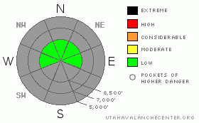
Danger by aspect and elevation on slopes approaching 35° or steeper.
(click HERE for tomorrow's danger rating)
|
Danger Rose Tutorial
|
The avalanche danger is generally LOW with a caution for localized wind slabs along the highest peaks and ridgelines. As always, avoid steep slopes with recent wind deposits. Hitting rocks is probablby the largest hazard since there is only about a foot of snow at the hightest elevations. |
|
|
CURRENT CONDITIONS |

|
We've had a few variable, mountain-level clouds overnight and ridgetop winds have picked up to 15 mph from the west and northwest. Temperatures are around 12 degrees.
The Ogden area mountains, have about a foot of snow along the upper elevation, north facing slopes. If you want better coverage, you can make a trip to the upper elevations of the Salt Lake area mountains where there is around 3 feet of snow with a solid base capped with nice powder on top. |
|
|
RECENT ACTIVITY |

|
Yesterday, there were no reports of human triggered avalanches despite many people crawling all over the upper Cottonwood Canyons near Salt Lake City. |
|
|
THREAT #1 |

|
| WHERE |
PROBABILITY |
SIZE |
TREND |

|
|
|
|
| |
|
|
Over the next
24 hours.
|
|
|
The snowpack is mostly stable but with one caution: The winds have picked up overnight and on Ogden Peak they are blowing 15, gusting to 22 but they are much more reasonable on most ridgetops. now blowing . With a skiff of very low density powder on top, it doesn't take much wind to create dangerous wind slabs. You will find these mostly at the highest elevations and high ridgelines in downwind terrain. Luckily, you can easily spot wind slabs with their smooth, rounded shape, their hollow sound and their slabby feel. Today, as always, you should avoid any steep slope with recent wind deposits. Otherwise, the snowpack is mostly very stable. |
|
|
MOUNTAIN WEATHER |

|
We should have scattered, mountain-level clouds increasing to mostly cloudy by afternoon. Ridgetop winds will blow 15 mph from the northwest with speeds up to 30 mph on the highest peaks. Ridgetop temperatures will rise today from 12 degrees this morning to near 20 this afternoon, with temperatures rising to the mid 20's down at 8,000'.
The extended forecast calls for a brush-by storm passing to the east of us tonight and again on Sunday bringing a chance for light snow showers without much accumulation. |
|
|
GENERAL ANNOUNCEMENTS |
For the Wasatch Powderbird Guides schedule go to their blog
Dawn Patrol Forecast Hotline, updated by 05:30: call 888-999-4019, option 8,
Daily observations are frequently posted by 10 pm each evening.
You can get a free iPhone application from Canyon Sports to display the Bottom Line.
To get a daily avalanche advisory e-mail click HERE.
For a text only version click the upper left link under Search
For canyon closures call UDOT at (801) 975-4838
Send us your avalanche and snow observations. You can also call 801-524-5304 or 800-662-4140, or email to uac@utahavalanchecenter.org
Donate to your favorite non-profit – The Friends of the Utah Avalanche Center. The UAC depends on contributions from users like you to support our work.
We will update this advisory by 7:30 tomorrow morning. |
|
|
This information does not apply to developed ski areas or highways where avalanche control is normally done. This advisory is from the U.S.D.A. Forest Service, which is solely responsible for its content. This advisory describes general avalanche conditions and local variations always occur. |
|
This advisory provided by the USDA Forest Service, in partnership with:
The Friends of the Utah Avalanche Center, Utah Division of State Parks and Recreation, Utah Division of Emergency Management, Salt Lake County, Salt Lake Unified Fire Authority and the friends of the La Sal Avalanche Center. See our Sponsors Page for a complete list. |
