SPECIAL ANNOUNCEMENT |
 |
Celebrating the onset of winter, first snowfalls and the opening of Utah's ski resorts, executive chef Nathan Powers of the award-winning Bambara, a downtown Kimpton restaurant, has created "Snowstorm" specials to benefit the Utah Avalanche Center. From Monday, November 1 through Friday, November 12, a dollar from each “Snowstorm” special (only $13) will be donated to the UAC. For more info, find them online. |
|
|
BOTTOM LINE
Danger by aspect and elevation on slopes approaching 35° or steeper.
(click HERE for tomorrow's danger rating)
|
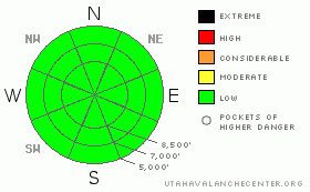
Danger Rose Tutorial
|
The avalanche danger is generally LOW. Mind the isolated shallow soft wind drifts along the highest elevations and sluffing in the steeper terrain that wasn’t sun affected yesterday. |
|
|
CURRENT CONDITIONS |

|
Clearing was short-lived overnight as the mostly cloudy skies signal the next storm – that’s….heading to the south. We may pick up 2-4” if we’re lucky. Mountain temperatures remain cold – 11,000’ temps plummeted to the single digits, and they remain in the low teens at most other stations. Winds are west to northwesterly and are generally less than 15mph. Riding conditions are good, though with some partial clearing yesterday, the sun played cat and mouse with the clouds, dampening some localized southwest and westerly facing slopes. Overall, it’s a good start to the season, with anywhere between 2 and 3’ of snow in the high northerlies of the upper Cottonwoods and the Provo mountains, and 1-2’ elsewhere. |
|
|
RECENT ACTIVITY |

|
Sluffing in the newest low density snow was the only game in town and occurred only with human provocation on the steepest slopes. They did not pack a punch. Don't forget to check for more details under Current Conditions in the bar up and to the left, or click here. Better yet, submit your own observation from your outing - you can find the link also in the upper left hand corner. |
|
|
THREAT #1 |

|
| WHERE |
PROBABILITY |
SIZE |
TREND |
|
|
|
|
| |
|
|
Over the next
24 hours.
|
|
|
‘Weak’ interfaces remain present a few inches within the storm snow on a soon-to-heal graupel layer and at the old boundary on the strictly shady slopes above about 9800’. The warm temperatures from the weekend helped to strengthen the weaker surface snow in the shady terrain and I feel that Monday’s warm snow will only further insulate and heal these faceted grains. Still, in this early season of spatial variability, there may be a few isolated areas in the highest coldest terrain where the lingering weak surface snow persists. As they say in academia, “More research is needed…” |
|
|
THREAT #2 |

|
| WHERE |
PROBABILITY |
SIZE |
TREND |

|
|
|
|
| |
|
|
Over the next
24 hours.
|
|
|
It’s a good time to practice your beacon drills, download the new software (if needed) for your beacon, consider the pros and cons of a new avalanche airbag, re-read Fesler and Fredston’s Snow Sense and Tremper’s Staying Alive in Avalanche Terrain. Check our Education page for classes and clinics near you. The UAC is changing its format and focus for the upcoming winter avalanche education season. Stay tuned for more dates and details. |
|
|
MOUNTAIN WEATHER |

|
We’ll have intermittent snow showers through tomorrow morning as the bulk of the next storm passes to the south of us. Temperatures will remain in the mid to upper teens. The winds will initially be light and variable, and then rotate out of the northeast, remaining less than 15mph. Gradually clearing is set for later Thursday into Friday. A cool northwesterly flow with some embedded disturbances is slated for the weekend into next week. |
|
|
GENERAL ANNOUNCEMENTS |
For the Wasatch Powderbird Guides schedule go to their blog
Dawn Patrol Forecast Hotline, updated by 05:30: call 888-999-4019, option 8,
Daily observations are frequently posted by 10 pm each evening.
You can get a free iPhone application from Canyon Sports to display the Bottom Line.
To get a daily avalanche advisory e-mail click HERE.
For a text only version click the upper left link under Search
For canyon closures call UDOT at (801) 975-4838
Send us your avalanche and snow observations. You can also call 801-524-5304 or 800-662-4140, or email to uac@utahavalanchecenter.org
Donate to your favorite non-profit – The Friends of the Utah Avalanche Center. The UAC depends on contributions from users like you to support our work.
We will update this advisory by 7:30 tomorrow morning. |
|
|
This information does not apply to developed ski areas or highways where avalanche control is normally done. This advisory is from the U.S.D.A. Forest Service, which is solely responsible for its content. This advisory describes general avalanche conditions and local variations always occur. |
|
This advisory provided by the USDA Forest Service, in partnership with:
The Friends of the Utah Avalanche Center, Utah Division of State Parks and Recreation, Utah Division of Emergency Management, Salt Lake County, Salt Lake Unified Fire Authority and the friends of the La Sal Avalanche Center. See our Sponsors Page for a complete list. |
