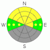
BOTTOM LINE
Danger by aspect and elevation on slopes approaching 35° or steeper.
(click HERE for tomorrow's danger rating)
|

Danger Rose Tutorial
|
The backcountry avalanche danger is MODERATE, and human triggered avalanches are possible. The most likely place to trigger a 1 to 2’ deep slide is on the shady northwest through northeasterly facing slopes, below about 10,000’. Sensitive, fresh drifts of windblown snow along the ridgelines and the possibility of a few wet, loose sluffs from daytime heating round out today’s avalanche concerns. When localized areas of instability exist, the assessment burden is on YOU to locate them. If you are uncomfortable with this task, keep your slope angles low. |
|
|
CURRENT CONDITIONS |

|
A moist, southwest flow is responsible for this morning’s mild temperatures in the 20s and 30s and the trace to an inch of snow. The southerly winds have picked up in the last few hours, and the most exposed ridgetop stations are averaging 20 to 30 mph, with gusts to 40. Elsewhere, averages of 10 to 15 mph are the norm. The last remnants of decent powder are on sheltered, mid and upper elevation shady slopes, with pervasive crusts elsewhere. |
|
|
RECENT ACTIVITY |

|
There was no new avalanche activity reported yesterday, for the first time in what seems like weeks…or has it been months?!? Though it is a numbers game, and yesterday’s lack of activity could be a mirror of the lack of backcountry travelers. |
|
|
THREAT #1 |

|
| WHERE |
PROBABILITY |
SIZE |
TREND |
|
|
|
|
| |
|
|
Over the next
24 hours.
|
|
|
The most active player in our snow pack continues to be the layers of surface hoar and/or near surface facets buried about 1 to 2 feet deep. This weak layer is most widespread on slopes below about 9,000’, that are sheltered and northerly facing, and in many areas are pockety in nature – found on some open slopes, in the openings in the trees, or even to the ridgelines. Slides triggered on this weak layer are averaging 50 to 150’ wide, and this weak layer seems particularly widespread along the Park City ridgeline, upper Mill Creek, terrain north of I-80, and in the Provo area mountains. |
|
|
THREAT #2 |

|
| WHERE |
PROBABILITY |
SIZE |
TREND |
|
|
|
|
| |
|
|
Over the next
24 hours.
|
|
|
The gusty southerly winds will be drifting some snow along the ridgelines, especially at the higher elevations. While these fresh drifts should be shallow today, they may be quite easy to trigger and should be avoided on steep slopes. |
|
|
THREAT #3 |

|
| WHERE |
PROBABILITY |
SIZE |
TREND |
|
|
|
|
| |
|
|
Over the next
10 hours.
|
|
|
And finally, today’s warm temperatures combined with any afternoon breaks in the cloud cover could lead to a round of small, wet, loose sluffs on steep sunny slopes. Also, any prolonged period of low elevation rain could trigger similar wet loose sluffs, especially on shady northerly facing slopes. |
|
|
MOUNTAIN WEATHER |

|
A cold Pacific storm system will reach northern Utah tomorrow. Ahead of this storm, we will be under a moist, southwesterly flow today, and temperatures will warm into the mid to upper 20s at 10,000’ and upper 30s at 8,000’. The southwesterly winds will average 10 to 20 mph, with gusts to 25. Along the highest ridges gusts could reach into the 40s. Occasional snow showers this morning could give way to partial clearing this afternoon. Increasing clouds and wind tonight, with the cold front reaching northern Utah by Thursday morning, possibly accompanied by lightning. Mountain snow, occasionally heavy, will continue through Friday morning, and storm totals should be in the 8 to 16” range. |
|
|
GENERAL ANNOUNCEMENTS |
Please contact Snowbasin ski patrol (801620-1000/1017) if you trigger a large avalanche in the backcountry, especially if you are adjacent to a ski area, to alert them to the slide and whether anyone is missing or not. Rescue teams can be exposed to significant hazard when responding to avalanches, and do not want to do so when unneeded. Thanks.
Discount Lift tickets: Ski Utah, Backcountry.com, Alta, Deer Valley, Park City, The Canyons, Wolf Mountain, Snowbasin, Beaver Mountain, Brighton, Sundance, and Solitude have donated a limited number of tickets for sale at discounted prices.
Wasatch Powderbird Guides flight plan.
Dawn Patrol Forecast Hotline, updated by 05:30:888-999-4019 option 8.
Daily observations are frequently posted by 10 pm each evening.
Free UAC iPhone app from Canyon Sports.
Subscribe to the daily avalanche advisory e-mail click HERE.
UDOT canyon closures UDOT at (801) 975-4838
We appreciate all your avalanche and snow observations. You can also call us at 801-524-5304 or 800-662-4140, or fill out the observation form on our home page.
Donate to your favorite non-profit – The Friends of the Utah Avalanche Center. The UAC depends on contributions from users like you to support our work.
The information in this advisory is from the U.S. Forest Service, which is solely responsible for its content. This advisory describes general avalanche conditions and local variations always occur.
We will update this forecast tomorrow morning. Thanks for calling. |
|
|
This information does not apply to developed ski areas or highways where avalanche control is normally done. This advisory is from the U.S.D.A. Forest Service, which is solely responsible for its content. This advisory describes general avalanche conditions and local variations always occur. |
|
This advisory provided by the USDA Forest Service, in partnership with:
The Friends of the Utah Avalanche Center, Utah Division of State Parks and Recreation, Utah Division of Emergency Management, Salt Lake County, Salt Lake Unified Fire Authority and the friends of the La Sal Avalanche Center. See our Sponsors Page for a complete list. |
