SPECIAL ANNOUNCEMENT |
 |
The avalanche recording on our phone lines has a glitch and we are stuck with a two-day-old recording. So please use the web or the podcast.
|
|
|
BOTTOM LINE
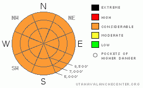
Danger by aspect and elevation on slopes approaching 35° or steeper.
(click HERE for tomorrow's danger rating)
|
Danger Rose Tutorial
|
Today is a dangerous day. Stay on slopes of 30 degrees or less and out from underneath steep slopes. There is a Considerable avalanche danger on most slopes, from several different kinds of avalanches, wind slabs, wet avalanches, persistent slabs and deep slabs.
|
|
|
CURRENT CONDITIONS |

|
The wild lake-effect storm squalls yesterday morning. The Cottonwood Canyon resorts reported 8 inches of new snow yesterday morning with 18 inches of storm total for the past couple days and a water weight of around 1.5 inches. Temperatures have plunged into the single digits this morning under clear skies but temperatures should rapidly rise today to above freezing with increased wind by afternoon.
|
|
|
RECENT ACTIVITY |

|
Yesterday was a wild day with widespread, soft slab avalanches within the new snow on all aspects and elevations about 6-12 inches deep. These avalanches occurred because of high precipitation intensity during lake effect squalls in the morning in the Salt Lake and somewhat in the Ogden area mountains but with very little new snow in other areas. Of more concern, was several larger, skier-triggered avalanches to the deeper, surface hoar layer from February 9th, buried about 2 feet deep in the snowpack, which has produced about a bazillion, unintentionally triggered avalanches these past 3 weeks.. A skier triggered a monster avalanche on the big, northwest face of Gobbler’s knob. They triggered it from the 30-degree, gladed tree slope on the northwest ridge, which most consider to be “safe”. It propagated out onto the 38-degree face breaking about 800 feet wide and running about 1800 vertical feet. Luckily, the skier was able to ski off the slab to the side. Other deeper releases to the buried surface hoar layer include one in Neff’s Canyon, West Willow, Dutch Draw and the Snwobasin backcountry.
This entire winter has been one, long string of human triggered avalanches. According to our database, we have shattered our previous record for both unintentional, human triggered avalanches in the backcountry as well as people caught.
SO FAR this season:
252 unintentional, human triggered avalanches in the backcountry
52 caught
19 partial burials
5 total burials
11 injured
3 killed
|
|
|
THREAT #1 |

|
| WHERE |
PROBABILITY |
SIZE |
TREND |
|
|
|
|
| |
|
|
Over the next
24
hours.
|
|
|
Today, I am expecting some kind of serious avalanche accident. We have all the ingredients: it’s the first sunny day after a storm with great powder, powder-starved hoards and a very complex suite of avalanche problems—wind slabs, wet avalanches, persistent slabs and even deep slabs. Many people will not be able to resist the siren song of powder snow and sun. It’s all too complicated to explain here, but this is a good day to stay on gentler slopes of 30 degrees or less. The buried layer of surface hoar has been reactivated with 1.5 inches of water weight and people will probably get surprised today in pockets of 2 feet deep, dangerous avalanches. These are very common at mid elevations, such as in Big Cottonwood, Mill Creek and the Park City ridgeline.
|
|
|
THREAT #2 |

|
| WHERE |
PROBABILITY |
SIZE |
TREND |

|
|
|
|
| |
|
|
Over the next
24
hours.
|
|
|
Even though most of the avalanches within the new snow will have settled out by this morning, we are expecting rapid warming today with sun and increased wind this afternoon, which will almost certainly reactivate the new snow with both dry and damp slabs and sluffs 6 inches to a foot deep.
|
|
|
THREAT #3 |

|
| WHERE |
PROBABILITY |
SIZE |
TREND |

|
|
|
|
| |
|
|
Over the next
24 hours.
|
|
|
When the wind picks up this afternoon, expect wind slabs especially along the upper elevation ridges. |
|
|
MOUNTAIN WEATHER |

|
Today we will see rapidly rising temperatures from the single digits this morning to above freezing by afternoon. In addition, ridge top winds will increase to 30 mph from the southwest by this afternoon accompanied by high clouds. We will have a weak storm on Saturday with about 6 inches of snow, which will be warmer and denser than the snow on the surface today. Then, we should have clear skies until we get another cold front around March 4th.
|
|
|
GENERAL ANNOUNCEMENTS |
Please contact Snowbasin ski patrol (801620-1000/1017) if you trigger a large avalanche in the backcountry, especially if you are adjacent to a ski area, to alert them to the slide and whether anyone is missing or not. Rescue teams can be exposed to significant hazard when responding to avalanches, and do not want to do so when unneeded. Thanks.
Discount Lift tickets: Ski Utah, Backcountry.com, Alta, Deer Valley, Park City, The Canyons, Wolf Mountain, Snowbasin, Beaver Mountain, Brighton, Sundance, and Solitude have donated a limited number of tickets for sale at discounted prices.
Wasatch Powderbird Guides flight plan.
Dawn Patrol Forecast Hotline, updated by 05:30:888-999-4019 option 8.
Daily observations are frequently posted by 10 pm each evening.
Free UAC iPhone app from Canyon Sports.
Subscribe to the daily avalanche advisory e-mail click HERE.
UDOT canyon closures UDOT at (801) 975-4838
We appreciate all your avalanche and snow observations. You can also call us at 801-524-5304 or 800-662-4140, or email to uac@utahavalanchecenter.org
Donate to your favorite non-profit – The Friends of the Utah Avalanche Center. The UAC depends on contributions from users like you to support our work.
The information in this advisory is from the U.S. Forest Service, which is solely responsible for its content. This advisory describes general avalanche conditions and local variations always occur.
We will update this forecast tomorrow morning. Thanks for calling. |
|
|
This information does not apply to developed ski areas or highways where avalanche control is normally done. This advisory is from the U.S.D.A. Forest Service, which is solely responsible for its content. This advisory describes general avalanche conditions and local variations always occur. |
|
This advisory provided by the USDA Forest Service, in partnership with:
The Friends of the Utah Avalanche Center, Utah Division of State Parks and Recreation, Utah Division of Emergency Management, Salt Lake County, Salt Lake Unified Fire Authority and the friends of the La Sal Avalanche Center. See our Sponsors Page for a complete list. |
