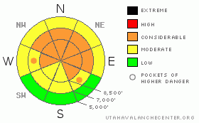
BOTTOM LINE
Danger by aspect and elevation on slopes approaching 35° or steeper.
(click HERE for tomorrow's danger rating)
|
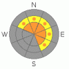
Danger Rose Tutorial
|
Wind and new snow are creating an Increasing Avalanche Danger today. There is a CONSIDERABLE avalanche danger on mid and upper elevation northwest through north through easterly facing slopes of about 35 degrees and steeper, for both new wind drifts and for slides breaking 1 to 2 feet deep on surface hoar. There is a MODERATE danger on slopes of 30 to 35 degrees. Slides can be triggered remotely from a distance or break out above you.
|
|
|
CURRENT CONDITIONS |

|
Under cloudy skies, it’s a warmer morning, with temperatures in the mid teens to mid 20s. The southwesterly winds jumped into the game overnight, and are now a significant player. Many stations are in the 15 to 20 mph range, with the more exposed peaks averaging 25 to 30 mph, with gusts to 40. Strong sun and warm temperatures yesterday baked the southeast through west facing slopes and the lower elevations, so they are heavily crusted, but there is good powder on sheltered, shady, mid and upper elevation slopes.
|
|
|
RECENT ACTIVITY |

|
I was once again swamped with avalanche activity this morning. There were 4 reported human triggered soft slab slides yesterday, in the UFO Bowls in the Provo area mountains, Mill B and South Monitor. There was also a larger, 400’ wide, remotely triggered hard slab avalanche on Lewis Peak. All 5 slides failed on the buried surface hoar. These slides are wider, 100’ – 400’ across. Also late reports of 4 people triggered slides from Monday, including 2 rides and one shoulder injury. Most are posted in Current Conditions. In addition, there was widespread wet avalanche activity on SE, S, SW, W facing slopes.
|
|
|
THREAT #1 |

|
| WHERE |
PROBABILITY |
SIZE |
TREND |
|
|
|
|
| |
|
|
Over the next
24 hours.
|
|
|
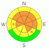
Even before the snow arrives, the wind alone has increased the avalanche danger. Sensitive drifts, or wind slabs, will be most common on northerly and easterly facing slopes, but snow will be also drifted onto other aspects and onto mid slope breakovers. Avoid wind drifted slopes where the slabby, dense snow will be easy to trigger.
|
|
|
THREAT #2 |

|
| WHERE |
PROBABILITY |
SIZE |
TREND |
|
|
|
|
| |
|
|
Over the next
24 hours.
|
|
|
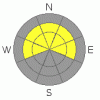
This storm will be a double whammy for the buried surface hoar, by both over loading it with more weight and by creating a better, stiffer slab above. Any slide triggered on the surface hoar in a wind drifted area today will be deeper, wider, denser, and much more likely to catch and carry you. Drainages that had less activity on the surface hoar may become more active today and tomorrow. Remember, with surface hoar, slides can be triggered on lower angle slopes, approaching 30 degrees, and remotely from a distance.
|
|
|
THREAT #3 |

|
| WHERE |
PROBABILITY |
SIZE |
TREND |
|
|
|
|
| |
|
|
Over the next
24 hours.
|
|
|
With the additional weight of the new snow, slides breaking on the weak layers near the ground could become more common again. Avoid steep, rocky shallow snow pack areas, including slopes that have slid one or more times this year, on west through north through southeast facing slopes.
|
|
|
MOUNTAIN WEATHER |

|
A Pacific storm system will move through the area today and tonight, bringing a very nice shot of snow. Today, areas favored by southwest to westerly flow will get the most snow, with areas favored by northwest flow catching up tonight. 4 to 8” of snow possible by dusk, with another 4 to 8” tonight. The southwesterly winds will increase this morning, with 25 to 35 mph averages common, and gusts across the highest peaks reaching 50 mph. Temperatures will be near 30 at 8,000’ and 20 at 10,000’. Winds will shift to the west this afternoon, and then northwest tonight, and decrease. There will be a break in the action on Friday, with a weaker, warmer storm this weekend.
|
|
|
GENERAL ANNOUNCEMENTS |
|
Please contact Alta Central (801-742-2033) if you trigger a large avalanche in the backcountry, especially if you are adjacent to a ski area, to alert them to the slide and whether anyone is missing or not. Rescue teams can be exposed to significant hazard when responding to avalanches, and do not want to do so when unneeded. Thanks.
Discount Lift tickets: Ski Utah, Backcountry.com, Alta, Deer Valley, Park City, The Canyons, Wolf Mountain, Snowbasin, Beaver Mountain, Brighton, Sundance, and Solitude have donated a limited number of tickets for sale at discounted prices.
Wasatch Powderbird Guides flight plan.
Dawn Patrol Forecast Hotline, updated by 05:30:888-999-4019 option 8.
Daily observations are frequently posted by 10 pm each evening.
Free UAC iPhone app from Canyon Sports.
Subscribe to the daily avalanche advisory e-mail click HERE.
UDOT canyon closures UDOT at (801) 975-4838
We appreciate all your avalanche and snow observations. You can also call us at 801-524-5304 or 800-662-4140, or email to uac@utahavalanchecenter.org
Donate to your favorite non-profit – The Friends of the Utah Avalanche Center. The UAC depends on contributions from users like you to support our work.
The information in this advisory is from the U.S. Forest Service, which is solely responsible for its content. This advisory describes general avalanche conditions and local variations always occur.
We will update this forecast tomorrow morning. Thanks for calling.
|
|
|
This information does not apply to developed ski areas or highways where avalanche control is normally done. This advisory is from the U.S.D.A. Forest Service, which is solely responsible for its content. This advisory describes general avalanche conditions and local variations always occur. |
|
This advisory provided by the USDA Forest Service, in partnership with:
The Friends of the Utah Avalanche Center, Utah Division of State Parks and Recreation, Utah Division of Emergency Management, Salt Lake County, Salt Lake Unified Fire Authority and the friends of the La Sal Avalanche Center. See our Sponsors Page for a complete list. |
