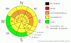
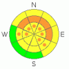
BOTTOM LINE
Danger by aspect and elevation on slopes approaching 35° or steeper.
(click HERE for tomorrow's danger rating)
|
Danger Rose Tutorial
|
There is a CONSIDERABLE avalanche on mid elevation, northwest through north through easterly facing slopes of about 35 degrees and steeper. Soft slab avalanches about a foot deep and 50 to 150’ wide can be triggered, and be especially dangerous if you are carried into trees. Elsewhere, there is a general MODERATE danger, with pockets of CONSIDERABLE at the higher elevations. Evaluate the snow and terrain carefully, and use good travel habits of one at a time.
|
|
|
CURRENT CONDITIONS |

|
Skies are partly cloudy this morning, and temperatures are cool, in the single digits to mid teens. Winds are from a westerly direction, and very light, with even the highest peaks averaging 10 mph or less. Slopes that have caught sun this week will have crusty, more challenging turning and riding conditions, while the powder on north is definitely something to write home about.
|
|
|
RECENT ACTIVITY |

|
There were 10 unintentional human trigger slides yesterday, averaging a foot deep by 50 feet wide, with the largest 150 ft wide. The pattern continues, with most of the slides triggered on more sheltered, mid slope, northerly facing slopes, and with the same guilty interface of surface hoar and/or near surface facets. Of note though, one slide was on an east facing slope, and one on a west southwest aspect.
|
|
|
THREAT #1 |

|
| WHERE |
PROBABILITY |
SIZE |
TREND |
|
|
|
|
| |
|
|
Over the next
24 hours.
|
|
|
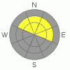
Today, on shady slopes, people will continue to be able trigger soft slab avalanches, about 50 to 150’ wide, breaking on the persistent weak layers of near surface facets and surface hoar that were buried about 10 days ago. As this layer strengthens, it is getting more stubborn, as two of yesterday’s slides broke on the second skier. While people are successfully escaping the smaller slides, a larger slide or a more stubborn slide breaking above you will take you for a ride and be quite dangerous if you’re carried into trees, off a cliff or dumped into a gully and buried.
As always, keep tabs on your aspect in relation to sun and wind. A few more reactive soft drifts will be found along the higher ridgelines today from slightly stronger overnight winds. Also, any longer break in the cloud cover will cause steep, sunny slopes to rapidly heat and slides could become easier to trigger.
|
|
|
THREAT #2 |

|
| WHERE |
PROBABILITY |
SIZE |
TREND |
|
|
|
|
| |
|
|
Over the next
24 hours.
|
|
|
Weak, faceted snow remains at the base of the snowpack, and there are still isolated places where a person could trigger a deep hard slab avalanche. Thin, rocky snow pack areas facing northwest through southeast are the likely terrain to trigger a slide to the ground. Included are some slopes that have already slid this year,
|
|
|
MOUNTAIN WEATHER |

|
Once again, while they’re talking feet of snow in central and southern Utah, we’re talking only inches up north. Skies will be partly cloudy this morning, with occasional breaks allowing the sun through. This afternoon, the clouds will thicken, and instability showers could produce 1 to 4” of snow. Temperatures will be cool today, in the low twenties at 8,000’ and the low teens at 10,000’. The westerly winds are forecast to average less than 15 mph at all elevations. A slightly stronger impulse is anticipated to cross northern Utah tomorrow afternoon, with 4 to 8” of snow possible.
|
|
|
GENERAL ANNOUNCEMENTS |
|
Please contact Alta Central (801-742-2033) if you trigger a large avalanche in the backcountry, especially if you are adjacent to a ski area, to alert them to the slide and whether anyone is missing or not. Rescue teams can be exposed to significant hazard when responding to avalanches, and do not want to do so when unneeded. Thanks.
Discount Lift tickets: Ski Utah, Backcountry.com, Alta, Deer Valley, Park City, The Canyons, Wolf Mountain, Snowbasin, Beaver Mountain, Brighton, Sundance, and Solitude have donated a limited number of tickets for sale at discounted prices.
Wasatch Powderbird Guides flight plan.
Dawn Patrol Forecast Hotline, updated by 05:30:888-999-4019 option 8.
Daily observations are frequently posted by 10 pm each evening.
Free UAC iPhone app from Canyon Sports.
Subscribe to the daily avalanche advisory e-mail click HERE.
UDOT canyon closures UDOT at (801) 975-4838
We appreciate all your avalanche and snow observations. You can also call us at 801-524-5304 or 800-662-4140, or email to uac@utahavalanchecenter.org
Donate to your favorite non-profit – The Friends of the Utah Avalanche Center. The UAC depends on contributions from users like you to support our work.
The information in this advisory is from the U.S. Forest Service, which is solely responsible for its content. This advisory describes general avalanche conditions and local variations always occur.
We will update this forecast tomorrow morning. Thanks for calling.
|
|
|
This information does not apply to developed ski areas or highways where avalanche control is normally done. This advisory is from the U.S.D.A. Forest Service, which is solely responsible for its content. This advisory describes general avalanche conditions and local variations always occur. |
|
This advisory provided by the USDA Forest Service, in partnership with:
The Friends of the Utah Avalanche Center, Utah Division of State Parks and Recreation, Utah Division of Emergency Management, Salt Lake County, Salt Lake Unified Fire Authority and the friends of the La Sal Avalanche Center. See our Sponsors Page for a complete list. |
