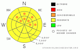
BOTTOM LINE
Danger by aspect and elevation on slopes approaching 35° or steeper.
(click HERE for tomorrow's danger rating)
|
Danger Rose Tutorial
|
There is a Moderate danger of sensitive, shallow, soft-slab avalanches within the new snow. Some of these avalanches may step down into deeper weak layers near the ground making very large and dangerous avalanches. We call these pockets of Considerable danger, which you will find especially on steep, rocky slopes with a thin snowpack. |
|
|
CURRENT CONDITIONS |

|
Yesterday, about 4 inches of foof spruced up our tracked-up, backcountry snow surface and 7-8 inches fell in the upper part of Little Cottonwood Canyon. We're expecting another 3-or-so inches today but with a little stronger winds from the southwest and west. Ridge top temperatures are a little warmer this morning than yesterday morning (15 degrees vs 10 from yesterday), so I suspect the new snow will be slightly slabby for the Utah snow snob. Temperatures down at 9,400' are 17 degrees. |
|
|
RECENT ACTIVITY |

|
If it ain't one thing, it's the other. Skiers triggered several, shallow, soft-slab avalanches yesterday on surface hoar and near-surface facets. A couple in the Lamb's Canyon area near Canyons Resort were 6 inches deep on 29 degree slopes. Evelyn intentionally triggered one in Cardiff yesterday 8 inches deep and 150 feet wide. |
|
|
THREAT #1 |

|
| WHERE |
PROBABILITY |
SIZE |
TREND |

|
|
|
|
| |
|
|
Over the next
24 hours.
|
|
|
I'm concerned about this weekend. We have a triple whammy of popular, 3-day weekend, people starved for powder and some tricky instabilities both within the new snow and deeper in the snowpack. Underneath this new snow, we have a couple weak layers: first, as the snow surface sat around under clear skies for many days, it turned into suggary, near-surface faceted snow, which can be persistently weak. Next, some mountain-level moisture the past few days have created a layer of surface hoar, which a fancy name for frost. Surface hoar is an especially tricky layer for several reasons: first, it's very thin and hard to detect, second, it extremely slippery and it tends to avalanche on surprisingly gentle slopes of around 30 degrees versus the 35 degrees we are used to. third, we don't get much surface hoar in Utah, so people are not used to it. In other words, the thin layer of delightful powder will give people some surprises. The Logan area seemed to have widespread surface hoar slides yesterday and I would suspect similar conditions in the Ogden area mountains. It's probably more pockety in the Salt Lake and Provo area mountains. Expect sensitive, soft slabs triggered on surprisingly gentle slopes. Be sure to put in good slope cuts before committing to a slope and pay attention to where an avalanche might take you. These avalanches tend to break at mid slope and even in at lower elevations such as creek bottoms, so pay attention. Finally, watch for wind drifting, which will make conditions much more slabby and create larger, more dangerous avalanches. |
|
|
THREAT #2 |

|
| WHERE |
PROBABILITY |
SIZE |
TREND |
|
|
|
|
| |
|
|
Over the next
24 hours.
|
|
|
Of equal concern, some of these new snow avalanches could easily step down to deeper weak layers near the ground, making very large, dangerous avalanches. These monster avalanches have become much more difficult to trigger and the trigger points exist in only isolated areas, but if you do trigger one, it will be huge and probably unsurvivable. Since avalanche danger is a combination of BOTH likelihood of triggering and avalanche size, these are what we call pockets of Considerable danger. You will find them mostly on steep slopes in thin, rocky areas. |
|
|
MOUNTAIN WEATHER |

|
We have a weak disturbance this morning, which should give us another 3 inches of new snow. This snow may be denser than yesterday's very light snow because temperatures are a little warmer and there may more convective activity, meaning there may be more graupel in the new snow. Winds may pick up as the weak front passes. This afternoon, snow should diminish and we could see some clear patches. Then, we have another, similar pulse coming through on Saturday, which could give us another 2-5 inches. |
|
|
GENERAL ANNOUNCEMENTS |
Please contact Snowbasin dispatch (801-620-1017) if you trigger a large avalanche in the Ogden backcountry, especially if you are adjacent to a ski area, to alert them to the slide and whether anyone is missing or not. Rescue teams can be exposed to significant hazard when responding to avalanches, and do not want to do so when unneeded. Thanks.
Discount Lift tickets: Ski Utah, Backcountry.com, Alta, Deer Valley, Park City, The Canyons, Wolf Mountain, Snowbasin, Beaver Mountain, Brighton, Sundance, and Solitude have donated a limited number of tickets for sale at discounted prices.
Wasatch Powderbird Guides flight plan.
Dawn Patrol Forecast Hotline, updated by 05:30:888-999-4019 option 8.
Daily observations are frequently posted by 10 pm each evening.
Free UAC iPhone app from Canyon Sports.
Subscribe to the daily avalanche advisory e-mail click HERE.
UDOT canyon closures UDOT at (801) 975-4838
We appreciate all your avalanche and snow observations. You can also call us at 801-524-5304 or 800-662-4140, or email to uac@utahavalanchecenter.org
Donate to your favorite non-profit – The Friends of the Utah Avalanche Center. The UAC depends on contributions from users like you to support our work.
The information in this advisory is from the U.S. Forest Service, which is solely responsible for its content. This advisory describes general avalanche conditions and local variations always occur.
We will update this forecast tomorrow morning. Thanks for calling. |
|
|
This information does not apply to developed ski areas or highways where avalanche control is normally done. This advisory is from the U.S.D.A. Forest Service, which is solely responsible for its content. This advisory describes general avalanche conditions and local variations always occur. |
|
This advisory provided by the USDA Forest Service, in partnership with:
The Friends of the Utah Avalanche Center, Utah Division of State Parks and Recreation, Utah Division of Emergency Management, Salt Lake County, Salt Lake Unified Fire Authority and the friends of the La Sal Avalanche Center. See our Sponsors Page for a complete list. |
