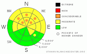
BOTTOM LINE
Danger by aspect and elevation on slopes approaching 35° or steeper.
(click HERE for tomorrow's danger rating)
|
Danger Rose Tutorial
|
Bottom Line Salt Lake, Park City, Ogden and Provo area mountains:
The avalanche danger is generally MODERATE, with pockets of CONSIDERABLE danger on the steeper northwest through north through northeast facing slopes at the mid and upper elevations. In isolated places it’s still possible to trigger deep, dangerous slab avalanches 2-4’ deep. Longer running sluffs are starting to pack some punch.
A MODERATE avalanche danger also exists on mid and low elevation shady slopes due to a buried layer of surface hoar from late January. Soft slabs can be triggered on slope or remotely, and be of serious size in steeper terrain.
|
|
|
CURRENT CONDITIONS |

|
Under partly cloudy skies, the southwesterly winds are light this morning, in the 5 to 15 mph range, with temperatures also reading 5 to 15, (though there are a few warmer spots in the Ogden and Provo mountains). There is excellent turning and riding in loud and fast recrystallized snow on the shady slopes, topped off with corn flake to potato chip sized surface hoar in many locations.
|
|
|
RECENT ACTIVITY |

|
It’s a super quiet morning in the office, with no avalanches reported from the backcountry yesterday. I suspect some are still recovering from Sunday's activity, while others continue to hit the steep lines. It is becoming easier to trigger decent size sluffs in the weak surface snow, and a few old, shallow wind slabs along the ridgelines are cracking.
|
|
|
THREAT #1 |

|
| WHERE |
PROBABILITY |
SIZE |
TREND |
|
|
|
|
| |
|
|
Over the next
24 hours.
|
|
|
Almost anywhere you go, the facets still lie in wait at the base of the snowpack. It’s a structural issue – there is a slab sitting on a weak layer and in places, and in isolated spots simply the weight of a person will trigger an avalanche. The most likely place to trigger a slide is in steep, northerly, rocky terrain in a thin snow pack area. It is worth heading out and looking in person at some of the more recent human triggered avalanches – a much better learning experience than the on line photos.
I find it interesting that many of the people involved in this winter’s avalanche incidents, fatalities, and close calls are in the 40 and over crowd. Perhaps we’ve experienced too many winters of stable snow, and we’re trying too hard to fit this winter’s snowpack into the average winter’s pattern of stability – the old Wasatch “wait a few more days, and it will be OK”, or want to use the results from a single strengthening snow pit to “verify” our wishes, or believe that we have the experience to “manage” the conditions.
|
|
|
THREAT #2 |

|
| WHERE |
PROBABILITY |
SIZE |
TREND |
|
|
|
|
| |
|
|
Over the next
24 hours.
|
|
|
Sitting on the snow surface is a widespread, thick carpet of loose sugary facets and surface hoar. Currently, triggered sluffs in this loose snow are starting to run fairly fast and far, and picking up just enough mass in steep terrain to knock you off balance or send you off a cliff in the wrong spot.
|
|
|
THREAT #3 |

|
| WHERE |
PROBABILITY |
SIZE |
TREND |
|
|
|
|
| |
|
|
Over the next
24 hours.
|
|
|
A layer of surface hoar was buried in late January on the shady low and mid elevation slopes in the Ogden mountians. Soft slabs can be triggered on slope or remotely, and be of serious size in steeper, longer avalanche paths or if a ride will land you in a terrain trap such as a gully bottom.. |
|
|
MOUNTAIN WEATHER |

|
Skies will be mostly cloudy today, with the cloud decks near or just below the mountain crests. Temperatures will warm to near 30 at 8,000’ and near 20 at 10,000’. The southwesterly winds will remain very light, generally less than 10 mph, with speeds gusts across the high peaks only into the 20’s. A few inches of snow are possible Friday and again on Monday, but the general pattern in a strong, persistent high pressure ridge, with no significant snow expected for 10 to 14 days.
|
|
|
GENERAL ANNOUNCEMENTS |
|
Please contact Alta Central (801-742-2033) if you trigger a large avalanche in the backcountry, especially if you are adjacent to a ski area, to alert them to the slide and whether anyone is missing or not. Rescue teams can be exposed to significant hazard when responding to avalanches, and do not want to do so when unneeded. Thanks.
Discount Lift tickets: Ski Utah, Backcountry.com, Alta, Deer Valley, Park City, The Canyons, Wolf Mountain, Snowbasin, Beaver Mountain, Brighton, Sundance, and Solitude have donated a limited number of tickets for sale at discounted prices.
Wasatch Powderbird Guides flight plan.
Dawn Patrol Forecast Hotline, updated by 05:30:888-999-4019 option 8.
Daily observations are frequently posted by 10 pm each evening.
Free UAC iPhone app from Canyon Sports.
Subscribe to the daily avalanche advisory e-mail click HERE.
UDOT canyon closures UDOT at (801) 975-4838
We appreciate all your avalanche and snow observations. You can also call us at 801-524-5304 or 800-662-4140, or email to uac@utahavalanchecenter.org
Donate to your favorite non-profit – The Friends of the Utah Avalanche Center. The UAC depends on contributions from users like you to support our work.
The information in this advisory is from the U.S. Forest Service, which is solely responsible for its content. This advisory describes general avalanche conditions and local variations always occur.
We will update this forecast tomorrow morning. Thanks for calling.
|
|
|
This information does not apply to developed ski areas or highways where avalanche control is normally done. This advisory is from the U.S.D.A. Forest Service, which is solely responsible for its content. This advisory describes general avalanche conditions and local variations always occur. |
|
This advisory provided by the USDA Forest Service, in partnership with:
The Friends of the Utah Avalanche Center, Utah Division of State Parks and Recreation, Utah Division of Emergency Management, Salt Lake County, Salt Lake Unified Fire Authority and the friends of the La Sal Avalanche Center. See our Sponsors Page for a complete list. |
