SPECIAL ANNOUNCEMENT |
 |
Special Avalanche Advisory
Unusually dangerous conditions exist today and through the weekend for most of the mountains in Utah. Many slope lie hanging in the balance waiting for a trigger, such as the weight of a person or snowmobile. These avalanches will be unusually large and mostly unsurvivable. Backcountry travelers should avoid all slopes approaching 35 degrees and steeper that face northwest, north, northeast, east and southeast at mid and upper elevations. |
|
|
BOTTOM LINE
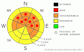
Danger by aspect and elevation on slopes approaching 35° or steeper.
(click HERE for tomorrow's danger rating)
|

Danger Rose Tutorial
|
The avalanche danger is what we call "Scary Considerable" with pockets of High on any slope approaching 35 degrees or steeper that faces west, northwest, north, northeast, east and southeast. Avalanches will be very large and unsurvivable. All backcountry travelers must avoid these slopes. You can trigger these avalanches from adjacent slopes, ridges or from below. |
|
|
CURRENT CONDITIONS |

|
Today is remarkably similar to yesterday with clear skies and warm temperatures. It's cold down in the mountain valleys, but it's a balmy 20-25 degrees on the ridge tops. Winds are light. There is very nice powder on the shady aspects but the sunny aspects have a sun crust. |
|
|
RECENT ACTIVITY |

|
Avalanche activity continues, even though it is many days after the storm. Yesterday backcountry skiers triggered yet another large avalanche in the Yellowjacket area of Gobbler's Knob. The slope collapsed when they were on a flat ridge and the slope below broke out 2-4 feet deep, 200' wide on a NNW facing slope at 8900'. Another backcountry skier triggered the northeast face of Murdock Peak, which is in the Canyons-Summit Park area. He triggered it from a 30 degree slope to the side and it broke out the whole bowl 3-4 feet deep. You can find more information in Current Conditions.
Avalanche control continued to produce very large avalanches near Park City (Limelight) and backcountry explosive testing produced a large slide in Mary Ellen, which is south of Snowbird. The Cottonwood Canyons resorts continue to produce several, localized, class 3 and 4 avalanches to the ground with explosives.
We have photos and details from the fatal accident in Meadow Chutes on Wednesday. |
|
|
THREAT #1 |

|
| WHERE |
PROBABILITY |
SIZE |
TREND |

|
|
|
|
| |
|
|
Over the next
24
hours.
|
|
|
Excuse me while I get on my soapbox here:
Not many people would go down a dark alley where there was a considerable danger of being attacked by a gang wielding knives and baseball bats. But for whatever reason, the word "considerable" doesn't get the same response when it comes to avalanches. Yes, we hate the word too, but we're stuck with it from an international standard. The new, North American definition of Considerable, which will go into effect next season is: "Dangerous conditions", and also, "Human triggered avalanches are likely."
Right now, the snowpack resembles a giant rat trap, cocked and loaded with an irresistible layer of powder cheese. Many slopes are just waiting to be tickled and the entire mountainside will shatter like glass, breaking down to the ground, creating a very large, mostly unsurvivable avalanche. What do we call these kinds of conditions? We have no idea. Danger ratings were not created to describe them. Better terms might include: "severe","don't go", "serious", "forbidden" or "What? Are you nuts?".
We are at hovering near the boundary between Considerable and High, or perhaps better described as a "Scary Considerable." Although the overall avalanche danger rating is Considerable, these avalanches are so large, they are valley crashers and tree snappers, plus, they are easily triggered if you hit the right spot, so I think it pushes them into the High range, at least on localized slopes. So I am sprinkling red dots on our danger rose.
Finally remember that most avalanche fatalities occur at Considerable because that is the maximum interaction between people and avalanches. As danger decreases after a storm, people's courage increases and X marks the spot where most people get killed. This game of Russian Roulette is just not worth playing. You need to adjust your slope steepness to the conditions (see the handy Swiss graphic). |
|
|
THREAT #2 |

|
| WHERE |
PROBABILITY |
SIZE |
TREND |

|
|
|
|
|
|
Continued warm temperatures will create some localized wet sluffs and perhaps some slabs on the sun exposed slopes. Use caution when the slopes heat up, especially in the afternoon. |
|
|
MOUNTAIN WEATHER |

|
Today's weather won't help people avoid temptation. The sun and warm temperatures make people feel great but remember that the snowpack does not share our opinion. The daytime high will be near freezing and winds will be light.
The extended forecast calls for a bit more snow on Saturday night through early Monday. |
|
|
GENERAL ANNOUNCEMENTS |
We desperately need to fund several projects. So be sure to attend the après-ski fundraiser at Snowbird for the Utah Avalanche Center, Saturday, February 6, 4:30-7, Hours d’oeuvres, beer, wine, music and silent auction. Golden Cliff, Cliff Lodge, $50. More information. Purchase tickets HERE.
Discount Lift tickets: Ski Utah, Backcountry.com, Alta, Deer Valley, Park City, The Canyons, Wolf Mountain, Snowbasin, Beaver Mountain, Brighton, Sundance, and Solitude have donated a limited number of tickets for sale at discounted prices.
Wasatch Powderbird Guides flight plan.
Dawn Patrol Forecast Hotline, updated by 05:30:888-999-4019 option 8.
Daily observations are frequently posted by 10 pm each evening.
Free UAC iPhone app from Canyon Sports.
Subscribe to the daily avalanche advisory e-mail click HERE.
UDOT canyon closures UDOT at (801) 975-4838
We appreciate all your avalanche and snow observations. You can also call us at 801-524-5304 or 800-662-4140, or email to uac@utahavalanchecenter.org
Donate to your favorite non-profit – The Friends of the Utah Avalanche Center. The UAC depends on contributions from users like you to support our work.
The information in this advisory is from the U.S. Forest Service, which is solely responsible for its content. This advisory describes general avalanche conditions and local variations always occur.
Evelyn will update this forecast on Saturday morning. Thanks for calling. |
|
|
This information does not apply to developed ski areas or highways where avalanche control is normally done. This advisory is from the U.S.D.A. Forest Service, which is solely responsible for its content. This advisory describes general avalanche conditions and local variations always occur. |
|
This advisory provided by the USDA Forest Service, in partnership with:
The Friends of the Utah Avalanche Center, Utah Division of State Parks and Recreation, Utah Division of Emergency Management, Salt Lake County, Salt Lake Unified Fire Authority and the friends of the La Sal Avalanche Center. See our Sponsors Page for a complete list. |

