AVALANCHE WARNING »
Dangerous avalanche conditions are occuring or are imminent.
Backcountry travel in avalanche terrain is not recommended.
|
 |
Notice: The Avalanche Warning has been continued for all the mountains of Utah. Strong winds and heavy snowfall have created a High Avalanche Danger. Both natural and easily human triggered avalanches are occurring at low, mid and high elevations. People should avoid travel on and below all steep backcountry slopes. |
|
|
SPECIAL ANNOUNCEMENT |
 |
Little Cottonwood is closed for avalanche control, and hopes to reopen by 8 or 8:30 am. Tomorrow, Big Cottonwood UDOT will do control work on Kessler, Argenta, and Stairs starting at 8 am, and hopefully opening the road by 9 am.
The Cottonwood Canyons are filling, so car pool or use the UTA buses!
Be sure to attend the après-ski fundraiser at Snowbird for the Utah Avalanche Center, Saturday, February 6, 4:30-7, Hours d’oeuvre, beer, wine , music and silent auction. Golden Cliff, Cliff Lodge, $50. More information. Purchase thickets HERE. |
|
|
BOTTOM LINE
Danger by aspect and elevation on slopes approaching 35° or steeper.
(click HERE for tomorrow's danger rating)
|
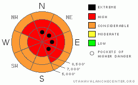
Danger Rose Tutorial
|
The avalanche danger is HIGH on slopes of about 30 degrees or steeper, with pockets of EXTREME danger on and below steep, upper elevation, wind drifted slopes. Both human triggered and natural avalanches are certain in steep terrain today. Avoid travel in all avalanche terrain. Natural avalanches have been occurring and slides are being triggered remotely from a distance, so also avoid travel below and adjacent to steep slopes. |
|
|
CURRENT CONDITIONS |

|
An unstable northwest flow has kept the snow going in the mountains, with most areas receiving 6” to 12” of new, light powder, and areas favored by northwest flow, including all of Little Cottonwood, mid Big Cottonwood, and Farmington Canyon pushing 18” overnight. Storm water totals are now 4 ½ to 5 inches in many locations. The northwest winds are in the 15 to 20 mph range, with gusts to 35 across most ridges. However, the higher, most exposed terrain is averaging in the 40s, with gusts to 60. Temperatures are in the single digits to low teens. With light, fluffy snow, the golden lining – face shots on low angle slopes, less steep than 30 degrees.
While this is one exciting storm and avalanche cycle, make sure you remain an observer in the audience of the avalanche drama, and not a participant. News of the weird is occurring – the “I’ve never seen slide that in 20 years” type of stuff, so re evaluate and be super cautious. |
|
|
RECENT ACTIVITY |

|
Yesterday, in the Salt Lake and Park City mountains very experienced travelers wisely stuck to the low angle slopes, but still triggered several slides remotely on adjacent, steeper terrain, often on their second or third pass in the area. In general, these hard slab avalanches were 2 to 5 feet deep, 200’ wide, failing on facets near the ground, and included terrain in areas such as Georges Bowl, Powder Park, Willows, McDonalds, and near Parley’s Pass/Peak. Explosive work at the resorts yesterday got big, deep, ugly avalanches to the ground, averaging 3 to 8 feet deep and 800’ wide.
The Ogden area mountains had several human triggered slides reported on slopes less steep than 35 degrees, including west, east and southeast aspects. Collapses were frequent, and road banks easily triggered. A large slide was released to the ground in Hells Canyon.
The Provo area mountains had a large, natural cycle, and highway control work released two 3 foot deep hard slabs on a northwest facing slope at 6,400’. |
|
|
THREAT #1 |

|
| WHERE |
PROBABILITY |
SIZE |
TREND |
|
|
|
|
| |
|
|
Over the next
12 hours.
|
|
|
Deep avalanches breaking down into the weak, faceted snow near the ground are the most dangerous avalanche concern, and have been averaging 3 to 5’ deep, and a couple hundred feet wide. Faceted snow exists on all aspects and all elevations, so deep avalanches can occur around the compass, north, east south and west, and from the ridgelines down to the low elevation creek bottoms and road cuts. |
|
|
THREAT #2 |

|
| WHERE |
PROBABILITY |
SIZE |
TREND |

|
|
|
|
| |
|
|
Over the next
12 hours.
|
|
|
In addition, the strong, northwesterly winds will be blowing and drifting the light snow, loading the southerly and easterly facing slopes for the first time this storm cycle. These new drifts of snow will be very sensitive, with both spontaneous avalanches and easily human triggered slides occurring. Once one of these new snow slides get moving, there is the potential for them to break out deeper, down to the ground. Human triggered and natural sluffs will run on steep slopes, especially in areas that received over a foot of snow last night or are wind drifted. |
|
|
MOUNTAIN WEATHER |

|
The last storm piece is moving through this morning, should drop another 3 to 6 inches of fluff, and then precipitation should decrease to isolated snow showers this afternoon. The northwesterly winds will maintain their brisk speeds throughout the day – 15 to 20 mph averages, with the high terrain averaging in the 40’s. Temperatures will be in the teens and low 20’s. A short lived ridge of high pressure will build in tonight, with a few smaller storms possible this week. |
|
|
GENERAL ANNOUNCEMENTS |
Discount Lift tickets: Ski Utah, Backcountry.com, Alta, Deer Valley, Park City, The Canyons, Wolf Mountain, Snowbasin, Beaver Mountain, Brighton, Sundance, and Solitude have donated a limited number of tickets for sale at discounted prices.
Wasatch Powderbird Guides flight plan.
Dawn Patrol Forecast Hotline, updated by 05:30:888-999-4019 option 8.
Daily observations are frequently posted by 10 pm each evening.
Free UAC iPhone app from Canyon Sports.
Subscribe to the daily avalanche advisory e-mail click HERE.
UDOT canyon closures UDOT at (801) 975-4838
We appreciate all your avalanche and snow observations. You can also call us at 801-524-5304 or 800-662-4140, or email to uac@utahavalanchecenter.org
Donate to your favorite non-profit – The Friends of the Utah Avalanche Center. The UAC depends on contributions from users like you to support our work.
The information in this advisory is from the U.S. Forest Service, which is solely responsible for its content. This advisory describes general avalanche conditions and local variations always occur.
Drew will update this forecast on Monday morning. Thanks for calling. |
|
|
This information does not apply to developed ski areas or highways where avalanche control is normally done. This advisory is from the U.S.D.A. Forest Service, which is solely responsible for its content. This advisory describes general avalanche conditions and local variations always occur. |
|
This advisory provided by the USDA Forest Service, in partnership with:
The Friends of the Utah Avalanche Center, Utah Division of State Parks and Recreation, Utah Division of Emergency Management, Salt Lake County, Salt Lake Unified Fire Authority and the friends of the La Sal Avalanche Center. See our Sponsors Page for a complete list. |
